The Heart of “La Ruta 40” – Part IV: The Lakes Region

It was in Chos Malal that my destiny with Liliana and Edgardo began.

Panoramic of the town of Chos Malal, from “la ruta” (the highway)

Edgardo is a doctor and Liliana an accountant and a life coach. They also have a construction business (and no, I have no idea if they ever sleep). One day, they decided that they were going to quit their jobs and travel for a month. So they headed off in their pick-up truck from San Juan to begin their journey through the Patagonia in Argentina and Chile.

As they were telling me about their decision, they called themselves crazy for taking such a risk, for deciding to embark on this adventure. I asked them why they thought they were crazy – did their kids and other family members call them crazy? They thought about it and replied that no, no one else had called them crazy. Then, in sync, they both said, “we call ourselves crazy”. They laughed at their surprising synchronized response and then high-fived each other. And I thought to myself, “I like these people.”

They let me join them on their way to the lakes region where they would head off to cross into Chile. (They later confided that they had been kind of nervous to give a ride to a stranger; it was very much out of their normal comfort zone. I guess that in the same way that my travels have opened my mind and led me to step out of my comfort zone and into new experiences, it had done the same for them.)

We weren’t strangers for long. On the ride, they shared some of their favorite music and presented me with the theme song of my journey “Ruta 40″ by La Renga. They then continued to introduce me to the cornerstones of “rock nacional” or Argentina rock (G.I.T., Charly Garcia, Fito Páez, Soda Estereo), and a range of other music that they love (Alejandro SanzLos Pericos, Pablo Alborán, Jorge Drexler, Joan Manuel Serrat, and Silvio Rodriguez). The experience reminded me how music can be such a uniting part of culture and people’s personal stories, and how powerful it is when people can connect over it and share it.*

When we parted ways, I was left with a reminder to follow my dreams, invest in things that that I’m interested in, and not let myself be fettered to the idea of maximizing my income or savings. And to not be afraid to sometimes just see where the road takes me.

It was sad to see them go, but it turns out that that was not the last I saw of them. Later, I saw them pass by in their truck when I was in Villa La Angostura! They honked and waved and we caught up by text message later. Then, a few days later, I was hiking through a park in Bariloche, lost in thought, when… who do I run into? Edgardo and Liliana! I have to point out here that there are countless places to go hiking in and around Bariloche, so it was quite a coincidence to run into them for a THIRD time during our travels! We took that as a sign that we were destined to be friends and so we have stayed in touch.**

City park in Junín de los Andes

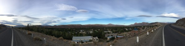
I parted ways with Liliana and Edgardo in the gorgeous area of “Junin de los Andes” and “San Martin de los Andes”. This is the beginning of the stretch of La Ruta 40 called “Camino de los Siete Lagos” or “Seven Lakes Route”, which starts in San Martín de los Andes and ends in Villa la Angostura. (Though one continues to see beautiful lakes as you continue past Villa la Angostura to Bariloche and on towards El Bolsón!)

It was here, outside of San Martin de los Andes, where I stayed in one of the most gorgeous spots of my trip – along one of those incredible lakes, Lago Faulkner. The weather was perfect – the sun was still strong enough to warm you up during the day, but it got quite chilly at night. And the wind!!! I always heard the wind in the Patagonia was strong. I don’t know if it was just this day or just this particular area, but the wind didn’t just blow, it whipped by! Walking along the lake, there were parts where the wind died down, but where the wind blew across the lake, it made waves as big as you could see on an ocean shore.

When the sun was shining strongly on the area of the lake where the trees blocked the wind, I took time to jump in the lake and go for a swim. Yep, it was freezing. I was glad those “polar bear swims” in Girl Scouts had prepared me for this. But once I was in, it felt good and I swam around for about 20 minutes, enjoying the crystal clear water and surprised every time the waves would lap me in the face.

Oscar, a former policeman who now helped look over some properties in the area, took me hiking around one lake and told me stories of some of the characters that he had met around the area. Many people come through and camp around the lake, but he had once even seen someone who came and stayed for more than a year, supposedly writing or working on some creative project. He also once came across a very unprepared camper who was freezing in her tent and he quite possibly saved her life by giving her a warmer place to stay. One of my favorite discoveries was that in one of the properties he took care of, there were some sculptures by a famous Argentine artist that worked with recycled materials.

The culture of the area kind of reminded me of the rural part of Texas where I grew up half-time, in that it has a big outdoors culture – fishing, hunting, hiking, camping, and watching shows like National Geographic and “Naked and Afraid”. I also met a modern day “gaucho” here. He was riding a horse to go check on his land and his animals.

The place where I stayed was literally off the grid. It got its electricity from a water turbine generator that was powered by water piped down to the house from high up in the nearby hills.

Water turbine power generator

In my travels so far, I had heard multiple times about the popular drink Fernet and Coke that had originated in the city of Cordoba, but was popular throughout the country. Finally I had my chance to try it with Oscar. Fernet is a grape-based spirit made with a mixture of a variety of herbs. It naturally has a bitter flavor, which is probably why they mix it with Coke. Originally from Italy, it was brought over by the great Italian immigration to Argentina in the early 1900s and is so popular here that they built a distillery in the country, and Argentina accounts for 75% of the world-wide consumption. Since Fernet is basically the unofficial official drink of Argentina, I had to try it.


Oscar also introduced me to the card game “escoba” (“broom”), which uses a Spanish deck of cards similar to the traditional poker deck… but completely different. It does not include the 8, 9 and 10 cards, so the jack is worth 8 (though it is marked with a “10”), there’s a horse worth 9 (though it is marked with an “11”), and the king is worth 10 (though it is marked with a “12”). To score points, you then have to make hands that add up to 15, remembering that some cards aren’t actually worth their face value. In conclusion, it is really confusing and challenging (but fun).

Speaking of confusing, that night there was an important Argentina fútbol (soccer) moment, that I only kind of understand. There were two important matches that would determine the champion of the Argentina Superliga Tournament. (Which is not to be confused with the Copa de la Superliga, which follows this tournament.) There are many fútbol clubs in Argentina, but the two most famous, with the longest history and the most fans across the nation are Boca Juniors and River Plate (pronounced “Ree-bear”). We watched the River game (Oscar’s preferred team), and unfortunately they tied, giving the championship to Boca Juniors.

The next day, I did yoga surrounded by incredible hills and crystal clear lakes before saying my goodbyes to the lakes region and my new friend Oscar and heading off to Bariloche.


Famous Footnotes:

*For you music lovers, I threw in a few links for you to have a taste of the soundtrack of our journey together. (Hopefully sharing this music with you makes up for my failure to be able to share music with them since I had been reserving the space on my phone for photos. Note to self for future trips: Take at least a few of my favorite songs along, especially if they’re somewhat representative of American culture (whatever that means!))

**(They had been able to cross into Chile and see part of the “Carretera Austral”, but their trip got cut short (like all of us) in mid-March, and they had to return back to San Juan, where they are now safe and sound, riding out the physical isolation measures, like the all of us.

Atacama Desert

The Atacama desert in northern Chile is known for the best stargazing in the world – and that’s why I HAD to come here. Ironically, I came during the two weeks of the year when it was cloudy and I didn’t get to do proper stargazing (other than a few minutes before the sunrise one morning.)

But, the sunsets!!! Even if I didn’t get to see the other suns of the universe, I got to see OUR sun in all its glory!

The dry desert air makes the incredible landscapes look exceptionally majestic and brilliant, and with a setting sun sending gold in all directions and casting deep blue shadows while tinting the clouds in pink, one will stop whatever she or he’s doing and run to catch the sunset every evening.

All the sunsets were awesome, but the most incredible was definitely in Laguna Tebinquinche*, where the sun set over the white, salt-covered lake and a rainbow emerged in the dark blue rainclouds opposite the sun.

Like many lakes here, the water appears to be covered in a layer of ice but is actually encrusted with a layer of white salt. The lakeshore is filled with “living rocks,” which are salty rocks made up of minerals and microorganisms that can survive some of the harshest environments on the planet. These microorganisms are some of the first living things that came into existence on Earth!

Contemplating the first life on earth, a flamingo flies across the sunset. And with friends made along the journey, we marvel at the beauty of life, the richness of the moment. We all just met each other, and yet we’re all family, born from Mother Earth, who is amazing us with her beauty.

But I digress. Being immersed in this vast desert, looking out across immense spaces and also out into the vast sky, makes one reflect on the grandness of the Earth, the universe, and the beauty of life.

While access to sensitive spots is limited to protect them, there was one salt lake that people can swim in. If you have never swam in a salt lake before, it’s definitely worth adding to the bucket list. Because salt water is more dense than fresh water, the saltier the water the more we float. I noticed the difference swimming in the Pacific Ocean in Lima, but it still didn’t compare to the unique sensation of floating in the salt lake in Atacama!

Look Ma! No hands!

When a large moist area of salty land has dried up, a salt flat (“salar”) is left behind. I saw many salt flats, with the the Salar de Atacama being the 3rd largest salt flat in the world (after those in Uyuni and Argentina). It is so large it can be seen from space.

I was lucky enough to see a few other marvels of the desert during my stay in Atacama, the most grandiose being the National Reserve of the Flamingos (Reserva Nacional de los Flamencos). At 4,200 meters (13,800 ft) above sea level, we saw two beautiful mountain lakes that used to be one great lake until seismic activity of the Nazca and South American tectonic plates created some hills that divided the lake in two.

Another breath-taking desert lake is the laguna aguas calientes. Here, the diversity of the landscapes was overwhelming. There were huge dune-like mountains of black lava rock, a lake of hot water fed by an aquifer that sits on top of a volcanic magma layer, and red hills rich in iron minerals. All accented by the pink flamingos looking for food in the lake below.


Finally, the bike ride through the Valle de la Luna was a challenging adventure through the desert heat, where we met friends along the way, saw incredible rock formations, and watched rain develop across the flat desert plains – the same rain that cooled us off a few hours later.

One final fun fact. The Atacama desert is located on the tropic of capricorn. I’m pretty sure I learned about the tropic of Capricorn at some point in my life, but I didn’t really remember what it was. The tropic lines are the points where the sun shines directly overhead, due to the tilt in the Earth. The regions of land between the two tropic lines are considered “tropical” areas since they receive the most direct sun, typically creating warmer year-round climates than the rest of the globe.

Our guide explains the tropic lines with a drawing in the desert sand. The sign marks where the tropic of capricorn passes, which also happens to be a part of the Inca Trail.


Famous Footnotes

Unless you rent (or have) a car to go see the sites (which would be a great way to explore Atacama), the way to see things is through the tours offered by the various tour companies in San Pedro de Atacama. The tours I took were:

-Tour 1: Laguna Cejar, Laguna Piedra (the salt lake where you can swim and float), Ojos del Salar, and Laguna Tebinquinche (the salt lake with the amazing sunset).*If you take the tour of Laguna Cejar in the afternoon, it usually ends at Laguna Tebinquinche so you can see the incredible sunset here.

-Tour 2: Reserva Nacional de los Flamencos (Laguna Miscanti and Laguna Miñiques), Laguna Talar, and Salar and Laguna Aguas Calientes with overlook to Piedras Rojas

-Observatory ALMA tour (free but you have to get to the meeting point early to get on the list, as I described in my blog post.)

-I rented a bike and rode through “Valle de la Luna” all day (about 6 hours), and another afternoon I rode through “Valle de Marte” and watched the sunset from an overlook point nearby.

**I didn’t get to do a stargazing tour because of weather, but would definitely recommend one!

**I didn’t get to do the geyser tour because rain had washed out the road, but would also recommend that!


Tatacoa Desert – Huila, Colombia

The diversity of landscapes in Colombia is amazing, and one of those unique gems is the Tatacoa Desert, not too far from Bogotá, in Huila.

All within 32,000 hectares, the desert-like landscapes are filled with more than 100 varieties of cactus, petrified wood, and other-worldly rock formations.

While the majority of the area is dominated by grey-ish colored rock formations, the Tatacoa makes a sudden drastic change to red rock formations, and so is referred to by its two parts – the red desert and the grey desert.

Desierto Gris (Grey Desert)
Desierto Rojo (Red Desert)

The intense sun and extreme heat is something that the locals try to avoid by relaxing in the shade at mid day, and with long sleeves and brimmed hats the rest of the day.

Fun fact: Despite it’s heat, sand, and cactus, the Tatacoa Desert isn’t actually categorized as a desert; it’s technically a “dry forest” climate zone. (Though it’s what a lay person would call a “desert”.)

It was here in the Tatacoa desert that I discovered my favorite berry in the world – the Chichatop. I have never tasted a more delicious fruit (and I LOVE strawberries and blueberries… but this one topped them all!)
Sorry, I didn’t get a photo of my favorite berry, but I did get a photo of this edible fruit that grows in a cactus.

The desert is just a few minutes drive from the nice little town of Villavieja.* You can stay in the town and do a day trip to the desert, or you can spend the night at one of the hospedajes in the desert.

Many of them have pools (and even if you don’t stay in the desert, you an always pay to enter one of the pools for a much-needed cool-off).

On clear days you can see the faraway snow-capped mountains near Manizales, but these days you can’t see the white peaks. Due to global warming, the size of the snow caps has been diminishing over the years and they are too small to see now.

While a guide isn’t necessary to appreciate the desert, it is quite helpful to not get lost in the heat and to maximize your time seeing some of the highlights. I would recommend it especially in support of eco-tourism…it supports the local economy in a positive way, giving value to the preservation of the land and creating green jobs for the locals. Our guide specifically mentioned that he really loved the training he received to be a guide, learning about the landscapes and the history, and he hoped that he could continue to learn more to continue getting better at his job.

The Tatacoa is home to two observatories and they give viewing sessions every night where you can learn a few night sky fun facts and see a few highlights through a telescope and binoculars. I was super impressed to learn that the half moon is a C or a D shape in the US, but it’s more like a smile or frown shape here. (In other words, the we see the lit-up side from different angles so it seems to be rotated between the two hemispheres). Similarly, Casiopia is a “W” in the US but an “M” here (something I had noticed but just thought it was related to the time of the year I was looking at it!)

We looked at stars being born (in the Orion Nebula). And looking at the cloud of the andromeda galaxy, we saw more stars at one time than one sees in the entire sky. With a basic high powered telescope, binoculars, and a really knowledgeable star guide, it was interesting and entertaining, and I loved it! It was a perfect way to appreciate the desert night.

Famous Footnotes/Bonus Content:

*On the way back to Neiva, the largest city near Villavieja, I took a colectivo, which is like a taxi van that waits until all the seats are filled to leave. (I got lucky and was the last one so didn’t have to wait.) In the colectivo there was a couple from Bogotá, another backpacker from Europe, and two women from Villavieja. The women were quiet at first, but as we started chatting, they each had a fun sense of humor, and were very chill and friendly. They confirmed that the town is a pretty quiet and relaxed town, that lives off tourism and some farming and raising animals. That weekend was going to be less quiet than usual – the town was going to have a big celebration all weekend with a concert sponsored by the mayor.

Barichara – “The Cutest Town in Colombia”

Turns out that Colombia is full of tiny adorable towns, and I might have to revise my statement from my previous blog that Guatapé is the cutest small town, especially because it turns out that BARICHARA is popularly known as the cutest town in Colombia (“el pueblo más lindo de Colombia”). (Also it’s a UNESCO world heritage site.)

Upon hearing that, I revised my travel plans and went to investigate.

I would have to say that Barichara certainly deserves the title, though I would not change my statement about Guatapé, which is cute in a different (colorful) kind of way.

I am so glad I had the pleasure of visiting the small town of Barichara and neighboring Guane, where, with the natural landscapes, tranquility, and friendliness of the people, you feel relaxed from just breathing in the air of the countryside. It’s no surprise that so many city-dwellers come here for vacations to decompress and take a break from the noise and rush of city life.

Heading north from Bogota in a bus, I watched the city landscapes transform into rolling green hills. My seat-mate lives in bogota but does construction projects in a rural area a couple hours outside of the city, so he takes on the role of tour guide and points out all the interesting things along the way.

As I see more and more cows grazing, he points out milking stations and informs me that we are in dairy country. We pass a town statue indicating that we are in the self-proclaimed milk capital of Colombia where you can get fresh dairy products like milk, cheese, and yogurt.

In between the cute, small, rural towns were grazing pastures, houses of brick or adobe, kilns with tall chimneys for making bricks, and I was completely surprised when we passed a series of coal mines.

About 7 hours later, when I arrived in San Gil, the air was filled with that familiar smell of burning wood or vegetation that I encountered when stepping off the airplane in El Salvador and in Cairo. From the busy little city of San Gil, I hopped on another bus that takes me to the small, quiet town of Barichara in about 30 minutes.

With its cobblestone streets, adobe buildings and colonial Spanish style balconies and flower pots, it almost seems like the town hasn’t changed much since it was a Spanish colonial hub in the 18th century.

And the views! Located in the hills above a river valley, there are multiple overlook points where you feel tiny as you stand in awe looking out over the the Suarez river far below and the mountain backdrop in the far distnce.

The town is connected to the nearby tiny town of Guane by “the Camino Real”, a stone path through the countryside that takes about 1.5-2 hours to hike. It used to be an Inca trail and more recently was a rehabilitated by a German engineer in the mid 1900s.

The hike to Guane was divine. The sun shone down, birds and insects were singing and chirping, there was a cool breeze, and while it was extremely hot in the sun, it was cool in the shade (and the path was mostly shaded by trees).

This is going to sound weird, but it was kind of welcoming to arrive to the village and be greeted by the light smell of smoke in the air and cow or horse poop. I guess those smells of rural areas grow on you after a while. ?

Guane was a kind of magical place for me.

The mirador provided an incredible view of the river valley with the river rushing through, and I spent some time there taking it all in, and later chatting with a Venezuelan artisan.

In the middle of Colombia, in this tiny little town of Guane, there is a hidden gem – a fascinating little museum that recounts the site’s history from millions of years ago to the present. (I wasn’t allowed to take photos inside, sorry!)

There are incredible fossils of fish and shells and plants from when the site was under the ocean. There are artifacts, some writing in pictographs, and even a mummy from the pre-Colombian Guane (the town is named after a group of indigenous people that lived in the region).

There are paintings from Spain that had been brought over during the colonial times. And there were coins – from the original “patacones”, (imperfectly round, made of silver from the colonial mines), to the perfectly formed colonial coins fabricated after mints were built, to the current coins in circulation in Colombia.

Unfortunately, the artifacts from the Guane people are pretty much all that remain because they were forced to stop speaking their language and practicing their customs many generations back. In fact, present-day Guane is where those indigenous Guanes that survived the epidemics were sent to be forced to forget their language and culture and be educated in the Spanish colonial language and culture in the 1700s. Ironically, this incredible museum exists largely thanks to a dedicated priest who worked tirelessly to compile the fossils and artifacts in the late 1900s.

Barichara and Guane are located in the department (state) of Santander, which has its own little sub culture, for which it is very proud. In addition to beautiful landscapes and fascinating history, I got a taste of the Santandereana food and music (specifically “bambuco”), and I felt very welcome thanks to the incredibly friendly Santandereanos.

In a very embarrassing moment in Guane I found I didn’t have enough cash to pay for my lunch. Thinking quickly I asked if I could leave the rest of the payment with someone in Barichara and without flinching the woman said it was not a problem and gave me the name of a store where I could leave it. I was much more worried about the situation than she was.

Finally, I have to note that the hotel where I stayed (“Quédate Aquí”) is run by the nicest woman EVER. She made me feel so at home, cooked delicious food, and emanated a really loving and caring spirit.

I wish I could have stayed a few more days here, but I was intrigued to check out a theme park nearby…which I’ll tell you about next!

Sites of Sucre

Sucre is a colorful city, full of signs of its colonial history and teeming with life. A UNESCO World Heritage site, the capital of Bolivia, and the seat of the judicial power*, to me it felt strangely like a big city with a small town feel.

People from Sucre call themselves Chuquisaqueños because Sucre used to be called Chuquisaca and is the capital of the department Chuquisaca. During colonial times, the Spanish called the city “la plata” and it was the center of the region of Spanish rule called Los Charcas.

It bears the nickname “ciudad blanca” because of the traditional Spanish style white houses (not to be confused with Arequipa, Peru which has the same nickname but for the white stone of the region used in construction there.)

I only barely scratched the surface of this little gem (multiple other tourists had told me they had planned to stay only 2 days and had ended up staying a week or more), but I was just there a couple of days.

The best way to bring the city to life is to visit the “casa de la libertad” in the main plaza de armas, which is one of the best museums I’ve been to, and where you can see the original Declaration of Independence and get an excellent primer on the colonial history of the city…actually of all of Bolivia – and most of South America!

The guided tour of the museum explained the history of Spanish colonial rule, from the robbery of precious metals and the brutal treatment of the natives and African slaves, to the fight for freedom from Spanish rule – a history that is shared by the majority of South American countries, with heroes such as Sucre, Simon Bolivar, and Juana Azurduy.

Later I wandered into an art museum that gave a modern history lesson, told through alasitas – miniatures of everything. One day every year in Bolivia, vendors in the street sell everything in miniature, and this miniature version of things are called alasitas. I know, I didn’t get it either. But it’s a real thing. One day a year you can buy a doll-house sized version of just about every normal thing you might buy (toilet paper, detergent, clothes, everything!)

This little exhibit in the museum had collected alasitas throughout the years and told the history of the 70s, 80s, and 90s in Bolivia (mostly La Paz) through alasitas.

To my surprise, everyone I talked to told me I had to visit the cemetery. Finally, a French friend I made convinced me, and I have to say it was quite an experience. Not a Halloween-type experience. More like visiting a huge, beautiful, sacred park.

The entrance was as grand as the entrance to a palace, and it opened up to a huge manicured park with walkways lined with trees. It was so expansive it would have literally taken hours to walk all the different walkways to see all the different graves and mausoleums.

The walkways were lined with trees, and the air was filled with the sound of birds chirping on top of a very peaceful silence, the smell of flowers and cypress, and a mix of warmth from the sun and cool air in the shade. Workers were tending the grounds and planting flowers, and a few visitors were trending to their loved ones’ graves. At one point, in the distance I heard a woman sobbing loudly (wailing, really), and I felt the sadness of her loss, reminding me of the solemnity of the place.

The main walkway was lined with massive family mausoleums, and the other paths led to walls and walls of graves with locker-sized boxes decorated with memorabilia.

Interspersed were a few grave plots, and a few more large family mausoleums. There were large buildings dedicated to specific groups like rural teachers, union workers or people who had constructed certain roads.

The differences between the family mausoleums and the walls of hundreds of graves was both artistically interesting and also a distinct reminder of the huge class, power, and wealth divisions put in place by Spanish colonialism. (Not to say that previous societies didn’t have class divisions, just saying that in this particular place those divisions created by colonial rule are what are evident.)

I couldn’t have visited Sucre without some kind of outdoors adventure, so I went looking for the “7 cascadas” that the military guy in the taxi had told me about. It was an hour bus ride leaving the city, and from there I asked the locals to point me in the right direction. “It’s straight ahead, just follow the path”, they all said. And that’s when I realized I’m not as outdoors-expert as I thought I was, even after living in a rural place for three years, because I kept losing what they claimed was a clear path. Some young teenage girls trending a flock of sheep helped me find my way (after first laughing at me).

But I did eventually find all 7 of the waterfalls and was rewarded with a delightful swim in a pool beneath a waterfall.

On the way back (after getting lost one or twice), I ran into a group of Spanish, Germans, and Argentines also coming back from the falls, and we made our way back together, just catching the last bus back to the city and then exploring one of the markets together. This is why traveling alone never really feels like traveling alone.

Famous Footnotes

*La Paz holds the seat of the executive and legislative powers, which is why many call La Paz the capital, though Sucre is the constitutional capital of Bolivia

**The hostel I stayed in, Villa Oropeza, had a lovely garden area, good WiFi, and a super friendly staff, definitely one of my favorites so far!

Isla del Sol

La Isla del Sol is the biggest Lake Titicaca island, and it is also the most visited by tourists, due to its convenient location just a 2-hour boat ride from Copacabana, the popular tourist stop between Bolivia and Peru.

It is apparent that the island has developed around tourism – there is an abundance of lodging (hospedajes) and restaurant options, and even signs pointing the way to tourist points of interest like overlook points.

You know international tourists come through a place in Bolivia if you find a pizza restaurant, and there are a ton of pizza restaurants on Isla del Sol.

I was really struck by the beautiful architecture and especially the facades of many of the hospedajes, most of which incorporated rock or pebble to adorn traditional adobe construction.

It is also close enough to the mainland peninsula (with a tiny tree-covered island in between), that it is connected to the electric grid of the mainland, unlike Isla de la Luna, which relies on solar panels.

Isla del Sol has three different communities and is less densely populated than Amantaní, with approximately the same population but spread throughout the 14-square-kilometer island (compared to Amantaní’s 9-square-km). (But both much larger than the tiny 1-square kilometer Isla de la Luna with just one community of 27 families).

Just like the other two islands I visited, the geography is that of a mountain rising out of the sea…er, lake. (It is very easy to forget that I am on a lake and not the sea!)

The point is that everything is uphill from the shore. And even walking around from place to place on the island is like hiking in the mountains – a lot of up and down (which always feels like there’s more up than down) at 3,800 meters of altitude.

The boat I came in arrived at the port Pilko Kaina with Incan ruins to explore.

From there to the rest of the island was a surprisingly long climb up.

I really wondered if I was going the right way and if all this climbing was going to be worth it in the end. But I persevered, meeting some friends and some awesome views along the way.

I eventually wandered upon two other lost tourists and soon we came to a house which turned out to also be a fancy restaurant on the edge of Yumani, the community most frequented in Isla del Sol and full of restaurants and hospedajes.

They stayed to enjoy some gourmet food while I continued along in search of a place to stay the night and a cheaper lunch since I was on a really tight budget, and running low on cash at this point.

The site where I did eat lunch was indescribably beautiful. The view of the lake was breathtaking (literally and figuratively at 4000 meters above sea level)… so blue, and so immense, stretching as far as the eye could see. The only sounds were a few birds and a distant conversation in Aymará, with the light sea, er, lake breeze whispering past my ears. Ultimate peace.

And it was the best meal I’d had since Amantaní – fresh trout from the lake with some fresh veggies.

Later, heading to the lookout point to catch the sunset I met and chatted with a local woman selling souvenirs who appeared slightly younger than me and who had curious and rowdy 2- and 4-year-olds. She had lived in São Paulo, Brazil and so not only spoke Aymará (the local language on the island) and Spanish, but also Portugués from her time in Brazil. She had returned to Bolivia because she said they had been treated like second class citizens, her husband robbed at gunpoint a few times, and other Bolivian migrant friends injured or killed…she said her experience was that there was no justice as the government didn’t really value their lives, safety, and rights as immigrant workers. (USA, can we please not be like that???? Pretty please.)

After doing yoga and watching the sunset with her and her kids, I headed to another overlook point.

There I met a super sweet couple – a Spanish woman and an Argentine who ended up staying two extra nights and exploring the whole island (even the northern part which we had been told could be dangerous because of an inter-community conflict that started two years ago), and they said it was incredibly beautiful!

Unfortunately I was running low on cash and had to return to Copacabana the next morning to change money and continue my journey. So, after a delicious dinner of trout from the lake (yes, again!) I headed to my hospedaje and had my last peaceful, Lake Titicaca island sleep.

The next morning, after watching the sunrise and eating breakfast, I headed down to the dock, past the Fuente del Inca and saw the grand island entrance to the Yumani community.

I had the pleasure of chatting with a few local women while waiting for my boat. This might have been one of the highlights of my stay here. Using my handy language chart, I practiced my Aymará with them, and we were all highly entertained (even if they were laughing AT me not WITH me at times!) Similar to Isla de la Luna, most people have their farms where they grow the typical sierra (highland) crops- quinoa, wheat, corn, and a variety of potatoes, and animals (mostly sheep), while the income from tourism helps provide something extra.

With a farewell photo, I said “juspara” (thank you) “jakisiñkama” (goodbye)! and boarded the boat for my last ride across the majestic Lake Titicaca.

Isla de la Luna

Every morning at 8:30am, boats full of tourists leave Copacabana heading to Isla del Sol, with an option of stopping for an hour at Isla de la Luna. Planning just to go to Isla del Sol and stay the night, I boarded a boat and met up with the two traveler friends from London and Italy that I had met in my hostel.

It was a beautiful 2 hour boat ride and I even saw some little fish swimming along side of the boat. Instead of getting off at the first stop at the Isla del Sol, I stayed on with my new friends to go to the Isla de la Luna.

The boat only stops for an hour at Isla de la Luna and the guide on the boat says there’s not much to see there and you can do it in an hour…and they only give you an hour before the boat leaves to go to the Isla del Sol. And if the boat leaves without you, you’re stuck in the island until the next day because the boats only come once a day for an hour.*

Entering the island the smell of muña caught me by surprise and reminded me of my stay in Amantaní, the island in the north part of the lake. As I was walking up the stairs to enter the island with the other tourists, I passed a little 4-year-old boy who, without prompting, greeted me saying “Hi, my name is Miguel Ángel”! It was so adorable!

I started exploring late because I chatted for about 10 minutes with the guy who was charging for bathroom use, geeking out about the water and electricity access on the island. (Islands have always fascinated me because they present unique infrastructure challenges ripe for alternative energies and exploring the idea of sustainability.)

Geek out about the island’s infrastructure:

They used to not have power but now they use solar panels (“because the kids want their cell phones. And also tv.”) He said the panels are great but the batteries only last a couple of years and they have to be careful not to let them drain to zero or they stop working well. They use what look like basic car batteries that charge during the day.

They also have solar hot water heaters in most of the houses.

They use water from the lake but have to buy gas to power the pumps that pump the water up from the lake. (They charge for the bathroom in part to cover costs of the gas).

End Geek-out.

Finally, I headed up the hill to the ruins of the “temple of the virgins”, which was supposedly a type of boarding school for young women to learn to do womenly things in the Incan times.

There, I met an older woman from the island who explained that life living on Isla de la Luna is really calm and peaceful, and she liked it much better than the city (La Paz) where she lived for a few years. Here they grow their food, have a few animals- (llamas, pigs, chickens, sheep), they have fish farms within the lake, they and buy what they don’t have on the island from Copacabana. There’s a primary school and a church and a football field – everything they need, she said.

As I started to hike the hill from the temple to see what was on the other side of the island, I passed a woman knitting in the shade who asked if I was going to stay the night in the island.

“That’s an option?” I asked her.

Part of my travel purpose is to go off the beaten path and get to know some places and the people that live there… so when she said that her mother owned a hospedaje, I negotiated a price to include my meals, and I decided to stay the night instead of going back with the boat to Isla del Sol.

The boat companies from copacabana don’t promote the fact that there are hospedajes on the island, (maybe because it’s a tiny island and most tourists want more entertainment and conveniences? I don’t know.)

But if you are looking for a quiet and incredibly beautiful place to pass 24 hours (or more), where you can chat with one (or a few) of the 27 families that live on the island, learn about their daily lives, and walk along the perimeter of the 1-square-km island in the afternoon sun…then it’s worth the stay.

The tourists only come one hour per day, at the same time every day, and the community rotates selling things, collecting the entrance fee, collecting bathroom fees, and helping/keeping an eye on the tourists.

On the other side of the hill, and down the length of the island are the houses where the community (called Coati) lives…So the tourists only see the ruins and a view of both sides of the island from the top of the hill, but don’t see or go into the community, unless they stay the night.

The community of Coati, Isla de la Luna

The hospedaje where I stayed overlooks the lake, with a little pier extending into the lake. In the patio between the rooms are beautiful plants with flowers and the constant buzz of bees that I even hear from inside he room.

The quiet lapping of the waves on the shore can also be heard from inside if you listen closely.

This half of the island, the opposite side from where the tourists land, smells of muña for parts and eucalyptus for other parts.

I loved chatting with the woman who owned the hospedaje. It challenged my conversation skills a little because she wasn’t super talkative, but every time I asked her a question I saw her face light up a little and I felt her open up a little more, like she viewed me with a little less skepticism each time.

She commented that the president/government built part of the hospedaje last year (or at least convinced them that he did so they’ll vote for him at the end of this year), and the alcalde bought the water pump. The entrance fee to the island goes towards paying the locals to do restoration of the ruins or other community-based things.

The woman has 5 kids, one still living here on the island, a few in Copacabana and a few in other cities, but she’s content because they talk on the phone. When she first moved here with her husband (who is from here), there wasn’t running water or electricity so it was a rough adjustment for her, but she adapted, and now it is much easier with the solar power and pumped water. She feels at home now and likes that it’s quieter with less people than where she grew up, (in a community on the peninsula).

We chatted as the sun set over the pier, and she told me that tomorrow would be her turn to sell her artesanías in the temple so I would see her there when I leave.

In the morning, heading back over the hill to the other side of the island, I saw the little boy from the previous day, Miguel Ángel, walking with his mother, taking their sheep out to graze. She had a few of them on a leash, and the similarity to people walking their dogs in the morning made me smile. A few loose sheep stopped to eat and wouldn’t follow her so she sent Miguel Ángel to collect them, and I went to help herd sheep, while the talkative, friendly boy told me stories of his sheep.

This visit had a different feel than my stays on Ccotos and Amantaní, mostly because the business arrangement is different. Here, they are following a more traditional hotel-type tourism model, where the host is simply providing a space to stay, and doesn’t even live in the same area where the guest rooms are. Whereas in Amantaní and Ccotos they are following a homestay model where the tourist is a little more integrated into the daily life with the host – through sharing meals and sometimes community events, in addition to the guest rooms being more physically close to where the family lives and considered part of the family’s house.

While I personally preferred the homestay model and the culture-sharing atmosphere it fosters, I still greatly enjoyed my stay here. There aren’t many words to describe the peacefulness and beauty of this place, but hopefully you can catch a glimpse of it through the photos!

As I left the island in the morning for Isla del Sol, I saw the snow-covered peaks of the Cordillera Real in the distance, a reminder that I was on a lake in the middle of the Andes, not the ocean, and a foreshadowing of my future travels through Bolivia.

Famous Footnotes

*If you really needed to leave the island, you could pay a local a very high price to take you in a private boat to Isla del Sol or the mainland.

Travelogue: Adventures in Arequipa

Co-written by Miluska Pachas Moron

Haz click aqui para la versión en español.

To celebrate Independence Day of Peru, 28 of July, we headed to the 2nd most populated city in Peru – Arequipa. But, crazy as we are, we didn’t choose a relaxing vacation with umbrella drinks, enjoying the city…no, we chose the adventure vacation: 2 overnight hikes, first in the heat of Colca Canyon, and then in the freezing cold of the snow-capped volcano Misti.

In fact, the very day we arrived in Arequipa (a 16-hour bus ride from Lima), we headed straight towards the Canyon to get started on our trek down into the canyon the next morning, so we could return to Arequipa and climb Misti Volcano all within the 7 days we had in Arequipa.

Hiking Colca Canyon (without a guide)

Encouraged by a blog we read, we decided to do a 2-day Colca Canyon hike on our own, to enjoy leaving on our own schedule, hiking at our own pace, and hoping to do it cheaper than if we had paid a guide. It turned out well, and we share our experience here.

Our bus arrived in Arequipa en the early afternoon, and we headed directly to the “empresa” Centella to take a minivan to Chivay (15 soles), where we would spend the night and get a good night’s rest before starting the hike the next morning. At 3,650 meters above sea level, Chivay is a pueblo about 1.5 hours from the start of the hike down into the canyon. At night, the temperature got down to the low 30’s, just below freezing.

We stayed in a comfortable hostel called Rumi Wasi (22 soles), and coordinated to leave the next morning at 6:30am with a minivan that was giving a guided tour for a group of tourists and agreed to drop us off at the trailhead for the Colca hike, near Cabanaconde, for 30 soles. On the way to the trailhead, our driver explained some of the history of the area, including the two indigenous cultures that had lived in the different parts of the canyon, and the sophisticated canals they used to carry water from one part of the canyon to another.

We stopped in the plaza of a pueblo called Yanque where some children were doing traditional dances in traditional clothing for the tourists. In the distance, you could see Volcano Sabancaya smoking like a chimney (they said it was normal.) After about 25 minutes in Yanque, we stopped for 30 minutes in Cruz del Condor, a part of the canyon 130 meters higher than Chivay, where the huge condors can be seen flying above the rising walls of the canyon, with the backdrop of the majestic mountains on the other side of the canyon.


When we arrived at the trailhead for the Colca Canyon descent, there were a few different guided tour groups and a handful of people also doing the hike on their own. Our first day was a hike of about 7 km to spend the night in the canyon at “Sangalle”, where there is a group of hostels referred to as the “Oasis”, and the second day would be an early morning for a day of pure climbing back up to the rim of the canyon.

The starting descent was fun, like a trail run, with some tough parts, but mostly a smooth descent. We noticed that there are many different settlements, or pueblos within the canyon, in the walls of the canyon and below.

We arrived at the bottom of the canyon (2,200 meters above sea level) to a wooden bridge in a district in the canyon called Tapay, where there was an outhouse and a place to rest.

After crossing the bridge, we took a switch-back to the left – a steep ascent that was said to save about 40 minutes. After about a half hour, we arrived to a pueblo, “San Juan,” where the tour groups stopped to eat a 15-soles “menu” (soup and “segundo”, which is rice and a typical plate defined by the restaurant offering the “menu”), and where you could buy a bottle of beer for 10 soles – more expensive than in a night club in Lima!

After San Juan, we continued towards the pueblo “Cosñirjua,”, which was about an hour and a half, with the last half hour being a fairly tough climb, and arriving at a restaurant/hostel that has snacks, drinks, and a bathroom, all for a higher price than anywhere else in Peru…but not surprising considering there are no other options in the area and it’s not exactly easy to import things to the site. We bought a Gatorade that looked like it had been brought there about 100 years ago, took advantage of the bathroom and a short rest, and then continued the route towards Sangalle, where we would find the Oasis lodges.

We had heard that it would take about 2 hours, or 1.5 hours at a good pace, to arrive at the lodges so we opted to walk-run so we could rest in the horizontal position as soon as possible. The first part of the trail was a dirt road wide enough for trucks, and as we continued we didn’t see any signs, nor the pronounced descent that the blog had mentioned. We passed a woman outside her house washing clothes, and she pointed us to a turnoff to the left that we had missed a few hundred meters back.

Descending, we came to an overlook with a gazebo-like structure, took some fun photos, and continued the descent back to the base of the canyon. After about an hour, we came to another bridge, where we would cross back to side of the canyon we entered (though further down), and where we would find the lodges after 30 minutes of a steep ascent.

Caught up in the adventure, we hadn’t thought to try to reserve a space in one of the lodges, and almost all of the spaces were reserved when we arrived. Luckily, there was a room with 3 beds and its own bathroom with hot water that we got to ourselves for 30 soles each, in a lodge with a pool fed by naturally warm water from the canyon. The lodge also provided dinner for 15 soles – prices that are reasonable for most travelers, but quite high for the area, but again understandable that they are taking advantage of the limited options available.

We had read that we could buy snacks along the way, but we recommend that you bring all the snacks you need for the two days, and a way to treat water, because the snacks they offered in the lodge were limited supply and exorbitant prices – a bottle of 2.5L of water was more expensive than the room! Ok, not really, but it was half the price of the habitation – or 5 times the normal price of a bottle of water this size!

But luckily, the Girl Scout/Peace Corps WASH volunteer in me had brought everything I needed to treat water (Iodine pills and a Steri Pen) to have potable water for the next day.

The area is known as the Oasis because while most of the canyon is rocky, with desert-like plants, common in the “sierra”, this part had green grass (probably planted for the lodges, though we did see another naturally green part of the canyon where there was a waterfall, near where we had crossed the bridge.) We took advantage of the grass to stretch for about 15 minutes so our bodies could recover from the day’s hike and be ready for the next day’s ascent.

The hot shower, eating even the last grain of rice on our plates, looking for constellations (Scorpio dominating the sky in our case), and resting under the starlight in this corner of paradise, was the best way to recharge for the tough day ahead.

(Side note: At 8pm they turned off the power for the hostal, so if you need to charge phones or use the light, it’s important to do it before hand, and always good to bring a portable charger if possible.)

We had planned to start the ascent at 5:30am, as recommended by everyone, to avoid the heat of the day during the tough ascent, but our alarm didn’t go off, so we got a late start (story of my life…surely the fault of my late curse)! So we ate breakfast at 6am – the breakfast of gold – the most expensive breakfast ever: 10 soles for two pieces of bread with butter and jam, with a cup of tea/coffee, but also very necessary for the day ahead.

We hit the trail at 6:30am, and the scenery was incredible, as we ascended along with the sun, which painted the canyon walls more and more throughout the ascent. The first hour was peaceful, silent, like a walking meditation. During the second hour, the ascent got more intense, like a never-ending rocky stairway that made the quads and glutes burn with every step, not only carrying our own bodyweight, but also the weight of the backpack of water and supplies. A great workout in an incredible and peaceful corner of paradise!

Towards the end, it can be discouraging to look up because there are many “false peaks” where you think you are close to the rim, but it turns out you still have a ways to go. As the sun comes out, the heat intensifies, so it is important to have enough water and snacks to power you through, as well as sunblock, hat and sunglasses…and toilet paper just in case (and a bag to put used toilet paper to throw it away afterwards and not add trash to the trail.)

Almost 3 hours had passed and we didn’t see any sign of the rim, but suddenly a group of hikers appeared, descending from the top, and they told us we were just 10 minutes from the rim…just the words of hope we needed to awaken the surge of energy that carried us almost running to the top! We arrived 10 minutes before our planned arrival time, thanking our legs of steel and celebrating that we made it out alive and strong, even if exhausted!

After celebrating, we realized that we still had a 15-minute hike to the plaza of Cabanaconde, where we would be able to catch a bus back to Arequipa…but at least it was a flat 15-minute walk!

We were able to catch bus that left at 11:30am – just enough time to eat lunch before the 5-hour ride. And luckily, the bus stopped in the pueblos along the way, so we were able to pick up our gear that we had left in the hostel in Chivay.


Volcano Misti (5,825 meters) (Only for the strong-of-heart! Have you seen the movie Everest?)

Returning to Arequipa, we took a day to rest, try some of the delicious food in Arequipa, and to find a guide to climb the volcano Misti the following day.

To climb Misti, we went with a tour company that offers “pool service”, (puts you with a group of around 5-15 people), for a trek of 2 days and one night, and we paid 250 soles each. They also provided the warm gear (pants, jackets, gloves) needed for the extreme temperatures in the night and at the higher altitudes, tents, main meals, and sleeping bags.

We only had to bring a few basics: a hiking backpack, boots, (they rented the backpack and boots if you didn’t have them), light clothing for the first day of ascent (which would be hot), warm clothing for the night (which would be ridiculously freezing cold), snacks, and 5.5 liters of water – 4 to drink during the 2 days and 1.5 for the guides to cook with.

We rented hiking poles from them too because the ascent is steep and the descent even more tricky. And I heard that hiking poles eliminate about 25% of the strain on knees on the ascent, and 75% on the descent…so I was happy to pay to rent hiking poles now to gain a few years before I will need knee replacements!

It is recommended to climb Misti with a guide because it’s easy to get lost, and the altitude and cold really do affect the human body and its ability to think well, (and there are plenty of stories of people getting lost and dying).

The guide company picked us up from the hotel at 8am and we met up with the rest of the group to outfit our gear and head to the trailhead. A 4×4 brought us out of the city, to the base of the volcano, where we would start the ascent at about 3400 meters.

Between the hot sierra sun and the constant climb, with backpacks of more than 5 kilos, the sweat was pouring, and we tired quickly, with aching legs, hips, and shoulders. But like all marathon challenges, we took it step by step, advancing little by little, resting every 30 minutes to drink water and eat fruit to refuel.

Finally, after about 5 hours of hiking, we arrived at 4,600 meters, where we set up camp.

We were lucky enough to experience an unbelievable sight – the contrast of the awesome sunset in the west and the incredible full moon rising in the east – which made the intense cold that came with the setting sun, slightly more bearable.

setting sun

rising moon

We ate dinner as quickly as possible and immediately climbed into the tents to escape the cold and try to sleep 7pm-1am: our wake-up call to eat breakfast and start the climb before 2am.

The morning cold was like no other I have experienced, but luckily, the full moon was a huge light in the sky, illuminating our way through the snow. We learned that the secret was to move at a pace fast enough to stay warm and not die of cold, but slow enough so that the lungs could deal with the low levels of oxygen at that altitude.

The trek was like no other I’ve ever done – freezing cold, in the middle of the night – dark, but illuminated beautifully by the full moon, a steep ascent through the beautiful rocks and snow, at altitude. It was incredible. It was difficult – physically and psychologically. Our heads were hurting from lack of oxygen. Hearts pounding. Loving and hating every minute of it, all at the same time.

We were in a group of 7, and the majority didn’t make it to the peak because there were two different paces in the group but one guide stayed behind babysitting someone who had never been on a hike before, much less in the altitude, and kind of ruined it for the rest of the group.

I definitely recommend this trek (especially if you can time it with a full moon!), always remembering:

1. If you haven’t climbed a mountain or done a hike at altitude in the last few months and aren’t in shape, this is not a good hike to start with. Do easier hikes at lower altitudes, and work your way up to this one. Also, if you can do work-outs in the altitude in the week before the hike (without exhausting yourself), it will help immensely.

2. When going on hikes, take some plastic bags for trash, including bags for your used toilet paper, and don’t leave trash on the trail. Respect nature and leave it beautiful for the next person!

Travel Blog: Chachapoyas, Amazonas – Kuelap, Gocta, and more

I have had the great fortune to have found some incredible friends in my site, and not one day passes that I am not thankful for them! With two of my best friends, we had been talking about escaping Oxapampa and traveling together…and this year we finally made it a reality! We left the high jungle, or “ceja de selva” (eybrow of the jungle) of Oxapampa and we headed north to the other side of the country, to the “ceja de selva” of Chachapoyas, in the department of Amazonas.

The arrow points to Chachapoyas, and the red dot is Oxapampa.

Chachapoyas hosts tons of international tourists who come to see Kuelap (sometimes referred to as the Machu Picchu of the north), the grand waterfall Gocta, and tons of other ruins, artefacts, and beautiful natural sites, all a day trip from the city of Chachapoyas, where there are plenty of accommodations.

We were lucky to find a special and got a cheap flight from Lima to Jaen, Cajamarca, and from Jaen, we took a 4-hour bus ride (MovilTours) to Chachapoyas. (Some people fly into Tarapoto and get a car to Chachapoyas, which is about 8 hours in car. Or, there is always the option to take a bus from Lima to Chachapoyas, which is about 20 hours, and worth paying for the more expensive seats on a luxury bus like Cruz del Sur.)

In Chachapoyas, we stayed in Backpackers Hostel, and each day we did a day trip from Chachapoyas. Our itinerary included:

  • Day 1: Rodriguez de Mendoza – Leo’s cave (Caverna de Leo) and hot sulfur springs (Aguas Termales)
  • Day 2: Kuelap
  • Day 3: Gocta (waterfall)
  • Day 4: Karajía

We wish we had had about 2-3 more days to be able to visit Leymebamba, which is 3 hours from Chacha and home to the Laguna de Los Condores and a museum with bones, mummies, and artefacts found around the laguna and in the area.

Day 1 Rodriguez de Mendoza. After eating breakfast in a small restaurant (and laughing until we cried when the waitress took Carolina (who is Argentinian) for a non-Spanish speaking tourist and spoke really loudly and slowly and simply to her in Spanish), we headed to the terminal, where we caught a car to go to Rodriguez de Mendoza (S/20). It was a beautiful 2-hour drive through the majestic, green, rolling hills. There were also palm trees, which we were told were brought in by an outside organization to cultivate, but they didn’t really turn into a big venture so they aren’t really maintained, but they remain an interesting feature in the landscape.

In Rodriguez de Mendoza, we took a 20 minute car ride (S/5) to where a man named Leo gives tours of a cave on his property (S/20). (Slightly less sketchy than it sounds, but worth it!) Leo is about in his 60s and he led us up a hill, through his beautiful property, filled with native plants, coffee plants, and fruit trees, to the opening of a cave. He gave us all flashlights and led us down into the cave, which was many stories deep, with different levels and tons of great formations. He claimed it was incredibly extensive and that he could lead a 6-hour hike through the cave and still not see everything, but since we only had one hour, he proceeded to tell us what he thought each formation resembled (Biblical figures, animals, etc.) We were a little disappointed because we would have much preferred to walk around and see more of the cave, but overall, it was a really cool cave (and a great hike to and from the cave), so I’m glad we did it, and I would recommend it.

We then took a car about 15 minutes (S/5) to a site with a natural spring feeding thermal baths (S/3). This was my first time in thermal baths and I was enchanted by the experience. There were two pools of turquoise water, in the middle of nature, surrounded beautiful scenery on all sides. I don’t think I’ve ever swam surrounded by mountains on all sides, a tiny drop in the middle of paradise. The sulfur smell took a while to wash out of our hair, but it was well-worth it. We ate at a restaurant just above the springs, on the same property, and were lucky enough that two different cars gave us rides back to Rodriguez de Mendoza, where we caught a combi (van) back to Chachapoyas (S/15), just in time to be able to arrive before dark.


Day 2. Kuelap – ruins from a fort of the Chachapoyas culture (1100-1400 AD), in the high selva of Amazonas, with a recently-built teleferico (ski-lift type of air transport) over the mountains to arrive at the entrance. (Fun Fact: Machu Picchu is also tucked in a high selva zone, but in Cusco.) We talked to a guide agency in the plaza and secured a day trip to Kuelap, with teleferico, entrance fees and lunch included for S/75. Unfortunately, it was a drizzly, grey day, so we didn’t get quite the spectacular photos that one normally gets at Kuelap, but even through the mist and clouds, it was spectacular…and I would say that the mist and clouds passing through the mountains gave it an enchanting feel in its own right.

The teleferico …getting into a pod with 8 people and crossing green mountains and valleys, from tens of meters above, was an experience in and of itself.

Arriving at Kuelap, we had a light, beautiful (even if foggy) hike up into the mountains, where we began to approach the remainders of watch towers and walls some 900-years old. Approaching the main grounds, the entire settlement was surrounded be a wall, many meters high.

Entering, we saw the outlines and remainders of different parts of a city, living quarters, temples, storage areas.

And a llama. (Not sure if they brought in the llama for show like they do at Machu Picchu, or if llamas actually live in the area, but I’m guessing the former since llamas tend to live at higher altitude…sorry to burst your bubble.)

Our guide explained that Kuelap was used by the Chachapoyas nation independently from 1100-1450AD. Though the Chachapoyas were overtaken by the Incas, the site continued in use and didn’t change much under Inca rule because the Incas tended to let the people they conquered continue with their way of life, implementing certain additional administrative requirements to manage their rule.

In the mid 1500s, the Spaniard conquistadores came, and while the Chachapoyas resisted the conquistadores longer than most, they were finally overcome and forced to leave the site of Kuelap. Our guide was a great storyteller, and I liked that he made a point to distinguish between “assumptions” and “facts backed by evidence” (a difference that is lately getting confused by many popular mass media sources).


Day 3. Gocta – The 771-meter (2,530 ft) waterfall with two drops (registered as the 3rd or the 16th largest waterfall in the world, depending on who you ask). We wanted to do the hike to see the whole waterfall – both of the two drops, and we found someone who knew a guide from the village that could take us there and later pick us up for S/60.

The village that is near the waterfall (San Pablo de Valera) has organized themselves well and they require a guide from their village to accompany all visitors to the waterfall. (We paid our guide Maria S/40.) The village you pass through also charges an entrance fee (S/20), and they use the money to maintain and improve the trails to the waterfall, as well as to improve their own community. I really liked the system since it brings jobs and income to the local people while they maintain and conserve the natural area on their property, and also are able to share it with visitors.

The first stop was the pool at the base of the first drop. Unfortunately, we had another cloudy day without sun and with a little bit of rain a few times, but it was still an amazing hike with amazing views.

The second stop was a lookout point, where we could see both the upper and lower drops of the waterfall.

From there, because we had asked to see the lower drop as well, we continued the descent until we arrived at the huge pool at the very base of the fall. Again, it was cloudy, cold, and even rained a little, but that didn’t keep us from diving into the pool; afterall, how often does one get the opportunity to swim in the pool at the base of an incredible 771-meter waterfall? (Ok, I admit, it was way too cold to swim. I jumped in, screamed because it was so cold, and could only stand about 3 more minutes before I got out and hid under my rain poncho to warm up.)

From the pool, we descended about 1 hour to the nearby village where the hike ends. One of the local dogs had followed us from the very beginning, all the way to the village below, and my friends convinced our driver to let us drop the dog off closer to home.

Since we all have that adventurous spirit, we agreed that the all day hike was our favorite day of the whole trip…being surrounded by nature all day, bathing in a grand waterfall, climbing and descending, crossing through the mountains from one village to another, immersed in incredible landscapes…it was a perfect day for us all, one of the best in a lifetime.

Day 4: Karajía. For our last day, we decided on a half-day trip to Karajía (S/30 for a private car), which is where there are sarcophaguses (sarcophagi?) high up in a cliff .

It was a beautiful drive (as all the drives had been), that brought us to a little town, and from there, a short 30-minute hike to see the sarcophagi. You can’t get very close to them because they are high in the cliffs, but you can see them from below or from the sides.

Arrow points to the sarcophaguses

We dawdled a while, hiking around and taking photos and goofing off and enjoying the views, until we climbed back up the hill to the village.

Unfortunately, we only had four days to explore the area, but one could easily spend a week or more discovering Chachapoyas and the surrounding areas.

The amazing views, the history, the culture, the adventure….this trip had it all, with the best part being the memories shared, deepening our friendship, and finally traveling together – something we’d been talking about doing together for a year!

Wonder of the World

After not seeing any of my family members for a year and a half, I was so happy to see my mom and my aunts walk through the door of the Lima airport! It was also a little surreal to see them in Lima. My two worlds collided…here I was in Peru, where I am a Peace Corps Volunteer, living a simpler life in a rural area trying to integrate and live like a local, and I hadn’t seen my family this whole time, and suddenly my family was here and we were going on a family vacation here! (After a year and a half living here, I still had not had the opportunity to see Machu Picchu, and we were going to go together!)

So, that means I was going to be a tourist…something I have been trying hard not be, as I try arduously to “integrate”. This was going to be a super interesting experience as I tried to use what I had learned over the last year and a half – language, culture, and how things work in Peru –to navigate like a local, while being a tourist.

Beach time in Lima

What do I mean by that? Navigating transportation, the language, and trying to not always pay the “gringo price”. For example, in a restaurant in Aguas Calientes, they tried to charge an additional 20% on our bill, saying that all the restaurants do it. Considering that there was no notification in the menu or anywhere that they were going to charge an additional 20%, I had argue that it was unfair and that I wasn’t going to pay it.  I was super uncomfortable doing this kind of negotiating when I first got here, but after a lot of practice it starts to come naturally, (and I get a lot of practice, being of light-colored skin, because I often get quoted a price twice or three times as much as the going price).  But I digress.

With only 7 days of vacation, we had a pretty tight schedule, but the great thing about Peru – and Cusco is maybe the epitome of this – is that the journey is often as amazing as the destination. So even though we had a full day of travel the next day, (flight to Cusco, and 3-hour car ride to Ollantaytambo), it was full of great sites (and surprises).

In addition the beautiful mountains and scenery on the drive, we stopped in Chincheros, where we saw a demonstration of how wool from sheep and alpaca is made into wool thread and dyed to make textiles, (and of course had the opportunity to buy some great handmade items like shawls, scarves, hats (chullos), socks, gloves, sweaters, blankets, etc.

Chincheros – textile shop

And randomly…our driver was awesome, and completely coincidentally, had grown up in Oxapampa where I live now (which is very far away from Cusco).

The next day we started with a 3-hour train ride to Aguas Calientes to catch the 20-minute bus ride to Machu Picchu. And again, the journey itself to Machu Picchu was amazing and beautiful.

View from the train window (Ollantaytambo to Aguas Calientes)

But, of course, nothing compares to the marvel of Machu Picchu. As my Aunt Michelle said, she was a little worried she wouldn’t be that amazed because she had already seen so many photos of it online, but then seeing it in real life is just something completely different and stunning.

Adding to the photos of Machu Picchu on the internet that just can’t do it justice.

First, it’s got its views – Machu Picchu is set in one of the most amazing spots, tucked in the mountains of the high jungle, and therefore surrounded by verdant green mountains, and overlooking a valley.

Then, it is built on the side of a mountain, but engineered in a way that prevents it from being destroyed by the natural processes of erosion.

And unlike a lot of cities of today, it doesn’t exclude nature from its design, it incorporates it, keeping green terraces, and natural streams as an integral part of its structural and functional design.

You see an interesting combination of the complex shapes and rounded, soft edges found in nature, molded into the straight edges, corners, lines, and simple shapes of the human-constructed world.

For me, this was a sight where the beauty of nature comes together with creativity and engineering brilliance, and it demonstrates the evolution of human knowledge.

And while, the beauty and marvel of Machu Picchu is unique for its location and how well it has been preserved, even the journey back to Cusco, through the Sacred Valley, was a journey that was, in itself, a destination.

Sacred Valley – Pisaq

We were able to explore the ruins at Ollantaytambo and Pisaq, and enjoy the beautiful scenery of the Sacred Valley on the way back to Cusco…and still we barely scratched the surface of the sites that offer breathtaking views ruins that give hints into the lives of past civilizations.

Our final full day in Cusco, we explored a few sites nearby the City of Cusco, including the famous Saqsayhuaman (basically pronounced Sexy Womán), until we felt like we were experts in Incan mythology, architecture, and engineering (not even close).

Cusco from Saqsayhuaman

Turns out that 4 days in Cusco was a good amount of time to see a lot of the highlights, but an extra day, or few, would have been even better, to be able to see the city of Cusco itself, some museums, and maybe to take another day trip or two to some other cool spots like Rainbow Mountain or the salt farms.

It turned out to be an amazing trip with the family, and I am so lucky that they were able to come, and that we were able to experience these amazing sites together. While the role of being a tourist took getting used to, the role of translator, negotiator, and vacation planner was fun and challenging. In a way, for the first time in my life I felt like I was taking care of my mom and aunts, instead of the other way around. Considering that they have taken care of me my whole life, I was honored to be able to do that, at least for a few days.