Home in Barlioche

I certainly hadn’t planned on being in Bariloche for more than a month, but then, some of the best experiences of my travels have been unplanned. While most people can’t say that they’ve had some of their best experiences during these last few months, I have been so fortunate to be in great company in one of the most beautiful places on earth – a place that truly feels like home.

During my extended stay here, I have gotten the opportunity to explore one little nook of this beautiful corner of the world on a more personal level.

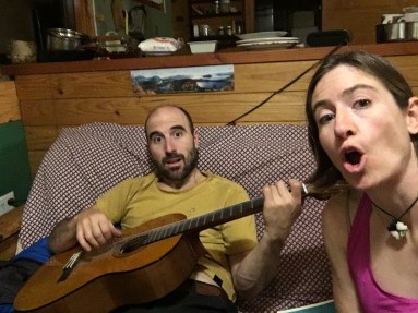
Thanks to my brilliant and fun roommate, host, and friend (Tomás), I found “home” in a safe, comfortable, eco-friendly, and gorgeous place, surrounded by good people.

Tomás has been my trail guide, my belay (while rock climbing and in life in general), slack line guru, the guitar and trombone in our 2-person house band (not sure what my role is…I guess back-up vocals), and really great company during 30+ days of lock-down.

Tomás has succeeded in (and shared with me) living a comfortable life connected to nature – close to great hikes, buying vegetables from the local vegetable vendors, eating greens from the garden, composting organic waste, and generating such a small amount of trash that we first took out the trash (a small bag) after I had been there nearly a month.

Taking turns cooking we shared vegetarian recipes and I learned a few secrets like how to cook dry beans and the magic of beer yeast as a condiment. I shared a couple of tricks I had learned in Peru (the amazing “ensalada rusa” and the power of adding ginger to a stir fry), and I almost …almost… got to a point where I enjoyed cooking.

Here, the backyard is a natural playground. There is the stream that you have to cross, hopping from rock to rock, carefully choosing your path so you don’t get stranded in the middle or foolishly land on a loose or slippery rock that pitches you into the water.

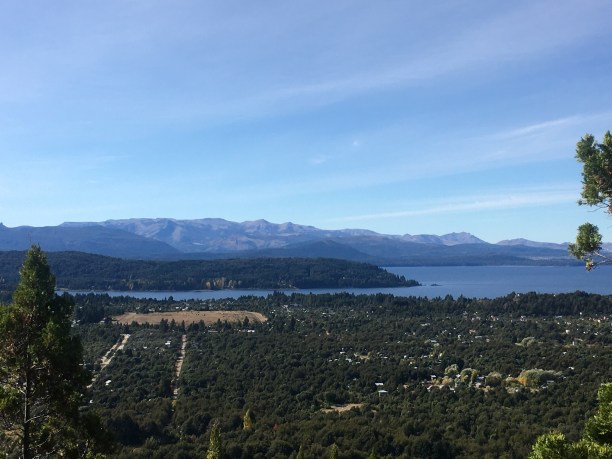
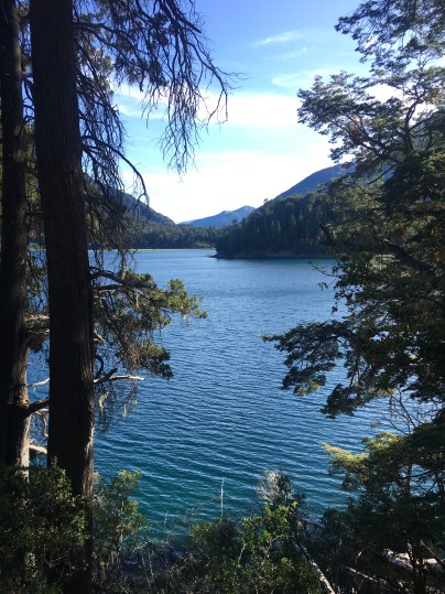
Crossing the stream opens up a whole new world. You can wander through trails parallel to the rising hills and rock faces in the south and ultimately find yourself on the lakeshore. Meandering along the lakeshore, you see where the stream you crossed earlier empties into the lake.

The beauty and serenity of the lake is like no other. Some times there is a strong wind that nearly blows you over and creates ocean-like waves on the lake. Other times, there is no wind and the lake is as still as glass.

Heading towards the mountain-like hills to the south is a network of trails that meander through the forest and hills. There are hidden waterfalls, rock faces for climbing, and trails taking you up to the peaks of the hills.

As you climb, every now and then you are rewarded with indescribable views of the lakes below.

View of the neighborhood from above. Tomas lives near the red tree along the visible road.

Walking through the forest there is a constant background sound of buzzing. At first I thought I was crazy but later I realized that it was the sound of yellow jackets. I saw a few buzzing around when we stopped in a clearing to rest on a log and do acro-yoga, looking out over the lake. But mostly they stay hidden and are heard but not seen, swarming in the trees. Except for that time that one stung me in the foot.* And that other time that one stung Tomás. A small price to pay for a beautiful day outdoors.

One spiny and annoying bush grabbed my attention (and my pants leg) ever since my first hike in the area.  It has a strange pear-apple-shaped red fruit that has nothing but seeds inside. I learned that this is the Rosa Mosqueta. An invasive weed that is really hard to get rid of.

One day my roommate and I had the bright idea to harvest the fruit and make tea. It turned out to be the best tea I’ve ever had in my life – and I’m not exaggerating! As it boiled, it put off an intense sugary sweet smell and the tea had a delicious apple-cinnamon flavor.

Speaking of harvesting fruits…you can find apple trees to provide an afternoon snack on the hike (or a week’s worth of delicious apple treats if you get serious about harvesting them).

Sometimes, walking through the forest, I smell Christmas trees. Though the pines are an invasive species here, the smell is lovely. Riding a borrowed bicycle through neighborhoods towards the main road, there are two spots where I smell that delightful smell of eucalyptus – one of my favorite smells in the world (but also an invasive). (Makes me wonder: Do all invasive trees have good smells?)

Speaking of the trees, the old Coihues are the best (and native, not invasive!) When we stumbled across a great Coihue towering above us, it felt like a guardian tree that could protect us from anything. It took three and a half people to hug that tree all the way around.

Then there are the cypress. Huge cypress trees tower above, painting the sky with a deep green on a deep blue sky backdrop. The hilltops are full of cypress, giving their rocky faces a green coat.

I’m not sure which trees change their colors in the autumn, but I was lucky enough to watch the hilltops change colors from pure green to a burnt-orange and red tint as autumn creeped in.


The trails in this area have provided a unique life lesson. My first time going for a trail run, I was filled with a mixture of nervousness about getting lost, but at the same time a sense of adventure, ready to explore my new “backyard”.

Within the first hundred meters, the trail divided into three forks and I had to choose which way to go. Shortly thereafter, it divided again. I took note of my choices so I could trace my way back and try the other options if I got lost or stuck. But the trail continued to divide, two and three and sometimes four forks every few hundred meters, like a maze, presenting me with countless choose-your-own-adventure-like decisions. With so many forks along the way, I quickly lost track.

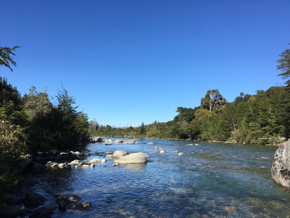
Some trails were narrower and I did a lot of ducking under low-hanging trees and bushes while others were wide open rocky trails, and I even encountered a road-like trail that seemed accessible for vehicles. A few times I passed through clearings that had been used as campsites, evidenced by the fire rings. And sometimes the trail spit me out along the stream bank. With the stream as a reference point, I knew I couldn’t get completely lost because I could always follow the stream back to the point behind my house.

As I continued to somewhat randomly choose my path forward at every fork, I realized that there seemed to be a great web of trails, most of them probably all connected eventually in some way. As long as I kept the stream on my right and headed away from the setting sun, I would be able to find my way. Sometimes I had to cut through some heavy brush, and sometimes I decided to retrace my steps and find a cleaner trail or to take a more scenic trail, but I was no longer worried about going in the “wrong direction”.

Famous Footnotes:

*That was my first time being stung by any type of wasp or bee. I couldn’t believe how much it felt like stepping on a nail. I’ve never stepped on a nail either, but I imagine that’s what it feels like. But it was a small price to pay for a beautiful day outdoors.

National Park Talampaya

The scenery on the way to the National Park Talampaya was enough to assure me that the detour to visit these parks was going to be worthwhile.

My plan was to enjoy the park all day today, and then find some nice people to give me a ride to the small town, “Baldecitos”, near the provincial park of Ischigualasto about an hour away.*

I arrived early to the park to figure out options for excursions through the park, and I opted for a group hike through a part of the canyon only accessible by foot. (If we returned early enough, I might be able to also do one of the more popular jeep rides that takes you all the way through the canyon to the other side).** Unfortunately, our hike kept getting delayed because a few of the group members that had reserved were apparently on their way but stuck in traffic.

While I was sitting at a table, trying really hard not to be impatient (I guess I had used all my patience the day before waiting in the shade of the fig tree), I overheard a group speaking in American English. My ears perked up because I haven’t met many American tourists during my travels. And while American tourists in Patagonia are fairly common, here in the middle of northern Argentina, it is not nearly as common to encounter other Americans.

I hesitated to introduce myself because they were all deeply engaged in their conversation, (and while in Latin America it would be rude NOT TO interrupt and greet someone, these were US Americans so it could be considered rude to interrupt.) I finally decided to introduce myself and I’m glad I did!

They were two couples (older than me but young at heart!) that love traveling and seeing new places around the world. They found themselves there all because American Airlines was going to stop running their route to Cordoba, Argentina, and one of the guys decided he wanted to take advantage of it before it was discontinued. And from there, things just started coming together for the two couples – who hadn’t seen each other in a long time (hence their deeply engaged conversation) – to be able to meet up there in Parque Talampaya.

It was so great to share travel stories and hear about some of their unique experiences (like Nude Zealand!), especially since they have been traveling for decades – (they gave me a few pro tips)! I was surprised to hear that their grown children were somewhat indignant about their decision to travel around the world instead of staying close by, near the grandchildren. (I don’t have children so maybe I don’t understand, but, Mom and Dad, you did your time – thank you! Now, get out and go see the world!)

When it was finally time to head out for my hike, I admit I was a little skeptical. We left at noon under the hot desert sun, and I was pretty sure we were going to shrivel up and dehydrate. But it turns out the wind picks up mid-day, and we took it slow, took advantage of shade spots, and stopped frequently, so it was actually didn’t feel like I was walking in the desert at the hottest part of the day.

The hike was all I had hoped for and more. Amazing landscapes.

Rock formations from the Triassic period (250 million years ago) – that’s before the formation of the Andes.

More recent dune formations where vegetation can grow.


Even ancient rock paintings from thousands of years ago.

The coolest part was when we came upon a herd of guanaco. Not only was it the first guanaco that I see in the wild, we were right there close to them, in their natural habitat! They let us get about 20 feet away before they finally ran off.

I think the thing that impressed me the most was that we could see where a fault line passed because there was a huge diagonal crack in the walls of the canyon on both sides.

Our guide drew a 24-hour clock in the sand and explained that if the history of the Earth were compared to one day, where the Earth formed at midnight, life appeared at about 3-4am, and the rock formations in the park (that formed 250 million years ago) formed at just one minute and 30 seconds until midnight at the end of the day! (We humans appeared at about 6-10 seconds until the end of the day!)


I stood in awe, with the beautiful, 250 milion-year-old canyon walls towering above me. I felt so tiny and at the same time I felt that I was traveling time, and through that time travel I was connecting to the extensive history of this planet, and somehow that made me both tiny and as big and as old as the planet, all at the same time.


When I got back from the hike that afternoon, it was time for that character-building activity of asking for a lift to Baldecitos, the little town near the entrance to the provincial park Ischicualasto. It shouldn’t seem like a big deal, but for a person raised in the US and raised to be self-sufficient and independent, it is a bit of a psychological challenge. One has to overcome embarrassment, shyness, and fear of rejection, all at once. So I set myself up near the parking lot and asked all the people who drove up where they were headed, and if they were going my direction if they would have room for one more person. About 5 different cars arrived and everyone was very friendly in their rejection, but they were not going my direction.

As one of the excursions returned, I found an older couple that was headed that direction and they were happy to give me a ride. The woman, Ana, was in her 60’s and she is a psychologist in Buenos Aires. They were at the end of their vacation and she had to get back to work after the holidays. She had a private practice and then also worked with the government to do psychological evaluations for people applying for commercial drivers’ licenses. She talked about how she had backpacked through Europe when she was younger and continued to travel as much as possible. They were then kind enough to go a few minutes out of their way to drop me off in Baldecitos, waiting to make sure I found a place to stay.

The woman who owned the hospedaje en Baldecitos was about my age and she lived next door with her little boy of about 12-13 years old. After I got settled in, I saw she was outside spraying the ground with a water hose to control the dust, and I came out and asked her about life in Baldecitos. She was a farmer, with milk and beef cows and also received some extra income from tourists passing through for the park. She was born and raised there in Baldecitos, which has just about 10-15 families living there permanently, with maybe up to 25-20 houses total! (Definitely the smallest town I’ve been in so far.)

A few months prior, they had constructed a cell tower in the town that was also supposed to also bring wi-fi for the community, but it was really spotty, with some of my whatsapp messages delaying a few hours to send.

I feel at home anywhere if I can do yoga with the sunset.

There was a “comedor” (small, simple, family-style restaurant) near my hospedaje where I went to see if I could get something to eat. While there, an older French couple came in also asking about dinner and about logistics for going to the park the next day. The man and older woman in the comedor told us they would serve dinner at 9pm, and that the park opened at 8am and was about 12km down the road.***

This park – Ischigualasto – is the park that you visit by driving through, caravan style, with a guide, stopping along the way to see certain parts. (I had read on blogs that many people without their own transportation look for other people to give them a lift through the park.) The couple seemed really nice and friendly, so I took that opportunity to ask if they had room for one more person, and they assented and said we could chat over dinner.

Over dinner I learned that they had rented a car and were driving down La Ruta 40, with destination Bariloche, but looking for cute little towns and beautiful, hidden gems along the way, just like me (except with a car). They already have grown kids, but they also have this beautiful child-like energy, getting really excited about the places they’ve seen and what there is to see ahead. My kind of people. We hit it off immediately and agreed to meet at 8am the next morning to go explore the Parque Ischigualasto together.


Footnotes:

* Dario (the park guide whose house I had stayed at in Pagancillo the night before) had assured me that many people go between the two parks and that I wouldn’t have a problem finding a ride from Talampaya to Ischigualasto. Since that was consistent with the blogs I’d read on the internet, I felt good about the plan.

**I like to know all the options before I make a choice, and here it took me about an hour to understand how it all works (and that’s after having done research online!) It turns out that this is only one of two different park entrances for the National Park Talampaya. At this entrance, there are two companies – one that offers excursions in jeep that leave on a set schedule every few hours, and another that offers hiking or biking excursions. It is all very confusing because the company that offers jeep excursions is also in charge of selling the Park Entrance fee, which makes it seem like their excursions are the only options. But if you ask around, you find that there’s a small office around the corner that offers hikes and bike rides if enough people are interested in forming a group. As a third option for exploring the park, there is another park entrance about 10km down the road, where a different company offers an excursion in jeep to see another part of the park called “Cañon Arco Iris” (Rainbow Canyon) and “La Ciudad Perdida” (Lost City). I also heard that there is another company forming that will do excursions to another part of the park next year.

***I chatted for a while with the couple in the comedor in Baldecitos asking them about life in Baledcitos. They presented another point of view about the park. They said that while they weren’t completely opposed to the park and tourism from the park did bring some income, they were kind of frustrated that it put restrictions on their ability to raise animals because it was a protected area (and to prevent accidents with the passing cars). They mentioned that would have liked to maintain the practices of their ancestors in the raising of guanaco and cattle in the wide open spaces. They also said that this provincially-managed park doesn’t provide the same job opportunities for people in the community of Baldecitos, like the nearby national park Talampaya which provides jobs for many people of the nearby town Pagancillo. They did mention that a consultation process was used to create the park, but they felt that their opinion was not considered. (The complexity of the situation was not lost on me, since I am reading about Latin American history during my travels. For example, I confirmed that they were specifically referring to their European ancestors who have inhabited those lands for hundreds of years. If you keep going back in time, you come to a point in time where their ancestors usurped the lands of the indigenous people living there. And maybe those indigenous people usurped the lands from someone before them.)


Small Town Hopping

I had been on my way to San Juan, when I found myself in that cute town of Chumbicha where I ended up staying a couple of days. Finally, when it was time to get back on the road to San Juan, I realized that I was really close to the National Park Talampaya and the Provincial Park Ischigualasto. (It took me a week of stumbling over that name before I was able to pronounce it.)

A French friend that I had met in Salta had recommended those parks to me, but it seemed that getting there and enjoying them without a car was quite a challenge. Was I up for the adventure of finding my way there? Or should I just head straight to San Juan? I figured I could ask for more information in the next major city (La Rioja) and make a decision based on what I learned.

I fortuitously caught a ride to La Rioja with two women from Chumbicha – a medical student and her mom. The mom was dropping her off in La Rioja where classes were starting back up for the semester. We filled the entire 1-hour ride with great conversation so that it felt like it ended too soon.

We joked about many cultural differences between the US and Latin America and between big cities and small towns, including the tendency to fire off personal questions to a stranger. She inquired if it had made me uncomfortable when she asked me all those personal questions, and I realized that I hadn’t even noticed.

I had to think back to realize that she had in fact asked me all the personal questions that might be considered intrusive and offensive to someone from the US culture but are typical of conversations among strangers in Latin America – “Are you married? Do you have kids? How old are you? Have you dated someone from here?…”

I guess I’ve gotten used to it, having lived in a small town in Latin America for 3 years. (I wonder if I have started asking people I recently met very personal questions, without realizing it…)

She reaffirmed what I had sensed about the town of Chumbicha. It’s quiet, there are some problems, but there was no real crime, everyone knows everyone, and everyone comes together to help each other out when there is a problem. Like any small community, everyone talks about anything and everything, so while it can be tricky to maintain a private life, she sets boundaries on what she shares with people. And she felt that people really accepted diversity within the community, in terms of lifestyle, religion, and sexual orientation.

As I walked into the bus station in La Rioja, I reflected on all the incredibly friendly people I had met and that little gem of a place I had found just because I had gotten off the bus at a random stop along the way.

So that’s why, about six hours later, I didn’t even think twice about getting off the bus in a small town that appeared on the map close to the parks where I was headed. I had never heard of it before. It wasn’t even mentioned in all the internet research I had done about getting to the parks. But it was located just 20 minutes from the national park, and the bus driver confirmed that there were places to stay there.

So as I gathered my things I went looking for a place to stay. I navigated away from the signs boasting rooms with personal bathroom and a swimming pool, and found a hand-painted sign “hospedaje” outside a tiny convenient store protruding out of a house. I called out and at first no one responded, but I hung around a minute – I’m not sure why, I guess I just had a good feeling about this place. After a minute, a young woman my age came out and told me the owner had just left to sign her kids up for school and was on her way back.

As I waited about 15 minutes for the owner to come back, I thought about how good I have gotten at this patience thing. Normally I would have been seriously bothered by having to wait more than a minute and I might have moved on. But I had no problem waiting, despite the fact that I was hot from the strong sun and hungry from traveling all day.

Some parrots (“loros”) flew overhead, and I took off my backpacks and stood in the shade of a tree. Suddenly something hit me on the shoulder. I looked around and realized that the fig tree I was standing under had just offered me some of its fruit. What great hospitality! As if it had known that I was hot and hungry!

Turns out that the humans were in fact just as kind and hospitable as the tree. After letting me get settled in a private room with its own bathroom and wi-fi, they invited me to share some mate (pronounced “mah-tay”) and some grapes (and raisins) fresh from their grape vine.


OK, I’ve mentioned mate in other posts, but I haven’t explained it yet. Mate is an essential part of Argentine culture. If you know an Argentine, you should know about mate because 99.99% of Argentines drink mate. (I made that statistic up.)

Mate is not just tea. It is a ritual.

Mate is an herb from northeast Argentina (and Paraguy and southern Brazil).

Mate is also the name for the round little insulated cup that you drink mate from (usually made of wood, a gourd “calabaza”, or metal).

It is drunk from a metal straw (“bombilla”) that is placed in the mate in a special way, with the mate tea poured on top. The hot water is poured into the same spot every time so that it forms a small little indention in the tea, but only in one spot, not disturbing the rest of the mate. When you drink mate, you finish all the water in the cup before refilling it. (I have had to learn all this mate etiquette, and I am still too intimidated to prepare a mate myself.)

Most importantly, mate is shared. It is shared with everyone you are with. But it is also shared with others as a cordial way of being friendly. (I was on a hike and came across a couple drinking mate on a large boulder. I said hi in passing, and they said hi back and invited me to share their mate, as if it was a natural part of greeting another person.)

It is a group activity.
It is an event (“let’s go drink a mate”).
It is a part of every gathering.
It is taken (along with a thermos of hot water) when you travel, on road-trips, on hikes.


While I’ve never been into sharing drinks with people, the gesture of someone offering you a mate is so nice that I admit that I shared a lot of mates before the arrival of the coronavirus here.

Mate is usually drunk “amargo” (bitter) – just hot water and tea. But some people prefer “mate dulce”, with sugar added.


Before I arrived in Pagancillo, I had only tried mate amargo, but there with Marisel and Dario I experienced mate dulce for the first time.** (I prefer amargo but dulce is also nice.)

As we chatted, I learned that Marisel runs the tienda (convenience store) and Dario works at the National Park where I wanted to go the next day. (That was lucky because I wasn’t sure how I was going to be able to get to the park the next morning and he said I could go with him!)

The young woman I had seen when I got there was a visiting park guard renting the room next to mine. When she returned from collecting algarroba (carob) beans, we walked down to the river together, taking our shoes off and following the river all the way back to the main road – a hike she hadn’t done before either.

Like many women my age I have met on this trip, she has a daughter that is just starting college this year. She explained that she lived in La Rioja with her daughter but had been doing the park guard exchange here for about a month and had fallen in love with the town. Now that her daughter is in college, she was thinking of moving to Pagancillo, she loved it so much.

Eating dinner at a local restaurant (on the next block over – the town is just a few blocks wide in each direction), I met a Porteña couple – a couple from Buenos Aires. They invited me to sit with them, and we chatted for hours. They were really passionate about the movement to legalize safe abortions in Argentina (all abortions are illegal in Argentina), arguing that many people end up dying from illegal and unsafe abortions, while others end up requiring extensive assistance from the government to care for unplanned children. (It is one of the larger, more popular movements at the moment in Argentina, and I have met many people along my journeys – men and women alike – that are passionate about it.***)

The information I had found on the internet about how to visit the national park in the area was really not very clear, and my new Porteño friends explained to me that there were actually two different companies, at two different park entrances, that led tours into the park…making it all less clear to me.

When I arrived back home late that night and shared a mate with Dario and Marisel, I learned that the majority of the park guards lived there in Pagancillo, and I would be able to take a van with Dario the next morning to get to the park. I had gotten pretty used to just figuring thing out as I go, so I prepared my things to take the next morning and then fell asleep to the backdrop of small town silence.

I had waken up in a random small town that I had never heard of before arriving (Chumbicha), and now I was falling asleep in another cute, small town that I had never heard of before arriving (Pagancillo). In both places I found a peaceful, almost utopian way of life with incredibly friendly people. I decided that small town hopping was going to be my primary travel strategy from now on.


Footnotes:

*Mate photo credit: wikipedia

**No photo credit: I failed to get photos with Dario and Marisel.

***The topic surprisingly came up in many conversations where I never would have expected it to. For example, riding back to Bariloche with an older man who was a cell phone tower technician brought it up and explained that while he would never let his wife to have an abortion, he still thought it should be legal and should be an option for women.


Surprise at Refugio Frey

Bariloche, Argentina. The Swiss Argentina. Argentina’s Boulder, Colorado. An amusement park for adult outdoors enthusiasts. Hippie haven. Patagonia.

There are many ways to describe this unique and beautiful little city of 150,000 people and its surrounding area. And each one gives you a little hint of what it’s like (though of course none of them can fully capture its essence).

Bariloche is a tourist hot spot, for both international tourists and national tourists, alike. (While here, I actually met more tourists from within Argentina (mostly from the capital, Buenos Aires) than international tourists.) It is a city on the shore of an extensive and beautiful lake, surrounded by hills, lakes, streams, and forested areas with trails, protected and accessible as municipal and national parks.

At the latitude of Colorado but in the southern hemisphere, they resemble each other in climate and somewhat in the landscapes too. In autumn (late April), the leaves turn colors, in the winter it snows and boasts a famous ski resort, and summer and spring provide great weather for hiking, rock climbing, kayaking, wind surfing, and surely many other outdoor sports that I just haven’t thought of in this moment.

One of the many things that was recommended to me was to hike up one of the mountain-like hills to “Refugio Frey”, a shelter at the top where one could camp overnight. Though I had just purchased a used tent, I was feeling like sleeping in a bed, so I decided to do the 6-8 hour round trip hike in one day.

While every day so far had been sunny, today it decided to rain. With a rain jacket and a poncho, I didn’t mind too much. There were still amazing views of the lakes and the city below (though I did imagine how much more incredible it might look with the sun shining directly on the lake below), and it was really refreshing to be out in nature.

In the last 40 minutes of the hike, it got a little cold and my fingers started getting numb. Then, in the last 10 minutes, the climb turned into a scramble over large rocks, and the wind picked up. As the path opened up, the wind started whipping so hard that it literally almost blew me over. The wind was cold, and I was wet. I caught site of the shelter and put my head down against the wind and ran to the entrance, which provided a wind break and made a world of difference.

Entering the shelter was like entering grandma’s warm kitchen at Christmas. The atmosphere filled with the warmth of a woodstove and chatter from other hikers sitting around tables, some speaking Spanish and others English. About 8 pairs of shoes were carefully laid out under the woodstove, so I took the cue and took off my wet shoes and left them there to dry.

I sat next to some Spanish speakers and started warming my hands as I took in the scene. A guy next to me asked if I was cold and I explained that only my hands were cold, but a woman on the other side of me told me to go grab the big heavy jacket hanging up and to put it on, explaining that it was hers and it would warm me up quickly. I felt like it was an order more than an offer, and anyway I wouldn’t have turned down her kindness even if I did feel bad for wrapping my wet self in her warm jacket.

She was there conversing with two other men, and eventually I got integrated into the conversation, and they even invited me to share some of their salami and cheese snack. In a previous life I would have been in a hurry to get back down the mountain. That is to say that the thought crossed my mind, with a twinge of anxiety accompanying it. But I reminded myself that in this journey, my goal is to slow down and meet new people and see new things.

Chatting with them, I learned that they had hiked up the night before and spent the night. The hike up had taken them much longer than anticipated, and they had to hike about an hour in the dark, arriving at 10pm! The woman, Dany, and her friend Faby were police officers from a rough neighborhood in Buenos Aires. For their vacations, they were visiting their friend Maty who used to live in the same rough neighborhood of Buenos Aires but was now living in a nearby province. They hadn’t really anticipated doing hikes on their vacation so they didn’t have appropriate shoes or gear and were kind of just winging it. They were on the last few days of their 10-day vacation and had just been going with the flow, and so far they were loving it.

Now that I am writing this about them, it shouldn’t have surprised me what happened next, but it did.

As I shared my story with them, they were surprised that I was traveling alone, that I had hiked up alone, and that I was going to go back down in the same day. I shared a little about my travels, where I was from, where I was going, and I jokingly said that I was always looking for travel companions. “Where are you going next?” they asked. I explained that I was thinking of either going to the mountain “El Tronodor” on the border with Chile or to El Bolsón, a smaller city to the south that had reputation for being cute and beautiful.

“Let’s go to El Bolsón!” one of the them threw out there. Maty pointed out that he had heard that it was “even better than Bariloche”. “Why not?” they half joked, noting that they hadn’t really planned anything and were just going with the flow and changing plans at every turn. The conversation continued to other things as we finished the mate and salami, and then a few minutes later Dany said, “OK, so are we going to camp here another night, or are we heading to El Bolsón?”

And that is how our friendship started.

We agreed that we would all hike down together, do some grocery shopping together, and then they would pick me up the next morning from where I was staying and we would head to El Bolsón together.

On the hike down we had a great time as I got to know them a little better. They were all really genuine people, not afraid to express gratitude for  their friendship and this experience, to share personal experiences and also to be goofy and joke around and tease each other.

Maty was the jokester who always kept us laughing and singing. Dany had an incredible knowledge of the different plants because a naturalist had lived with her for a few years and she had learned all she could. She was a super curious question-asker and a talker.

Fabi was the “guide” who led us down the trail – he was really athletic and able to go just about anywhere, for example finding a way down to the river to fetch water. He was somewhat soft spoken, with a great sense of humor, and was not afraid to let loose into song. Which was possibly my favorite part about the hike down – the many times they all busted out into song, including a wonderful cheesy song about friendship (“Un Amigo es Una Luz“) that was appropriate for the moment.

The 2-hour ride to El Bolsón was beautiful. I used my travel apps to try to find a good place to camp, but luckily our driver, Maty, ignored me and followed signs for camping near a river. After driving down a gravel road for about 20 minutes, we came to a perfect campsite next to a crystal clear river, with a view of a snow-capped mountain in the distance.

As we spent the next 24 hours together, each passing moment I realized moreso than before how incredibly lucky I was to have found these awesome people and that they had let me into their friend circle to share this little adventure.

Jokingly, (but for real), everyone had their roles. Fabi was the cook (even though he’d never cooked on a campfire before, he did an awesome job!) Dany and I gathered firewood. Maty and I set up the tents. I washed the dishes. Dany made sure there was always mate or “te cocido” to drink.

Over the next 36 hours or so together, we went on hikes, explored nearby rivers, lakes, and waterfalls, looked at the stars, cooked and ate together, and spent a lot of time chatting about life and joking around the campfire or in the car.

Our time together came to an end just in time actually, because the government closed the national parks and our campsite for the quarantine right after we left.

As we were driving towards where they would drop me off, they broke out in song once again, this time dedicated to me (“No es mi despedida“), and they all sang along at the top of their voices – a wonderfully cheesy and awesome moment that I will carry with me forever!


Tatacoa Desert – Huila, Colombia

The diversity of landscapes in Colombia is amazing, and one of those unique gems is the Tatacoa Desert, not too far from Bogotá, in Huila.

All within 32,000 hectares, the desert-like landscapes are filled with more than 100 varieties of cactus, petrified wood, and other-worldly rock formations.

While the majority of the area is dominated by grey-ish colored rock formations, the Tatacoa makes a sudden drastic change to red rock formations, and so is referred to by its two parts – the red desert and the grey desert.

Desierto Gris (Grey Desert)
Desierto Rojo (Red Desert)

The intense sun and extreme heat is something that the locals try to avoid by relaxing in the shade at mid day, and with long sleeves and brimmed hats the rest of the day.

Fun fact: Despite it’s heat, sand, and cactus, the Tatacoa Desert isn’t actually categorized as a desert; it’s technically a “dry forest” climate zone. (Though it’s what a lay person would call a “desert”.)

It was here in the Tatacoa desert that I discovered my favorite berry in the world – the Chichatop. I have never tasted a more delicious fruit (and I LOVE strawberries and blueberries… but this one topped them all!)
Sorry, I didn’t get a photo of my favorite berry, but I did get a photo of this edible fruit that grows in a cactus.

The desert is just a few minutes drive from the nice little town of Villavieja.* You can stay in the town and do a day trip to the desert, or you can spend the night at one of the hospedajes in the desert.

Many of them have pools (and even if you don’t stay in the desert, you an always pay to enter one of the pools for a much-needed cool-off).

On clear days you can see the faraway snow-capped mountains near Manizales, but these days you can’t see the white peaks. Due to global warming, the size of the snow caps has been diminishing over the years and they are too small to see now.

While a guide isn’t necessary to appreciate the desert, it is quite helpful to not get lost in the heat and to maximize your time seeing some of the highlights. I would recommend it especially in support of eco-tourism…it supports the local economy in a positive way, giving value to the preservation of the land and creating green jobs for the locals. Our guide specifically mentioned that he really loved the training he received to be a guide, learning about the landscapes and the history, and he hoped that he could continue to learn more to continue getting better at his job.

The Tatacoa is home to two observatories and they give viewing sessions every night where you can learn a few night sky fun facts and see a few highlights through a telescope and binoculars. I was super impressed to learn that the half moon is a C or a D shape in the US, but it’s more like a smile or frown shape here. (In other words, the we see the lit-up side from different angles so it seems to be rotated between the two hemispheres). Similarly, Casiopia is a “W” in the US but an “M” here (something I had noticed but just thought it was related to the time of the year I was looking at it!)

We looked at stars being born (in the Orion Nebula). And looking at the cloud of the andromeda galaxy, we saw more stars at one time than one sees in the entire sky. With a basic high powered telescope, binoculars, and a really knowledgeable star guide, it was interesting and entertaining, and I loved it! It was a perfect way to appreciate the desert night.

Famous Footnotes/Bonus Content:

*On the way back to Neiva, the largest city near Villavieja, I took a colectivo, which is like a taxi van that waits until all the seats are filled to leave. (I got lucky and was the last one so didn’t have to wait.) In the colectivo there was a couple from Bogotá, another backpacker from Europe, and two women from Villavieja. The women were quiet at first, but as we started chatting, they each had a fun sense of humor, and were very chill and friendly. They confirmed that the town is a pretty quiet and relaxed town, that lives off tourism and some farming and raising animals. That weekend was going to be less quiet than usual – the town was going to have a big celebration all weekend with a concert sponsored by the mayor.

Ciudad Perdida

If there was one thing I wanted to see in Colombia, (besides my good friends Adam and Adrienne), it was la Ciudad Perdida (“the lost city”). To describe the impact and significance of this archaeological site, many call it the Machu Picchu of Colombia. But unlike Machu Picchu, the only way to arrive to la Ciudad Perdida is a multi-day (4-7 days) hike through the hot, humid jungle of the Sierra Nevada, Colombia.

Translated as “The Lost City”, it was found overgrown by the jungle and being looted for precious stones (like most archeological sites in the world). In the 1970s, the Colombian government and archeologists were able to protect it and begin “recovering” it, (cutting the jungle back). This revealed the historic city – neighborhoods (terraces where houses once stood and walking paths that connected the at least 500 houses of the city) and ceremonial areas overlooking the surrounding mountainside.

In the 1980’s it was opened for visitors, and now you can access this unique site by trekking through the jungle with one of the 7 authorized tour companies. (And you can ONLY access it by trekking with one of these authorized companies). During the trek, you pass through two national park reserves (parques nacionales naturales), which are protected areas.

Since all the companies by law have to charge the same price, I chose to go with Wiwa Tours, which hires guides from the four native communities whose ancestors founded Ciudad Perdida and who still live there and in the surrounding lands, still practicing many of their traditional customs.

Our guide, Juan Daza, in Ciudad Perdida, explains a traditional process of making pots

Our guide explained that the site of Ciudad Perdida was home to the Tayrona (also “Tairuna” or “Teyuna”) culture, the ancestral culture of the four present-day, distinct but connected communities of the Sierra Nevada – the Arhuaco, Kogui, Wiwa, and Kankuamo. Each has their own language, customs and leaders, but they share this sacred site.

Ciudad Perdida was as interesting and mystical as Machu Picchu was for me, though in different ways. One of the most fascinating aspects was its connection to the present – the “mamo” and “saga”, or male and female community leaders from one of the four communities still lives on the grounds of Ciudad Perdida.

Mamo’s or Saga’s house in Ciudad Perdida

The communities still live in and around the surrounding lands and are involved in management of the tourism that comes through, receiving some of the financial benefits from it.* Each September, the four communities still gather at the sacred site of Ciudad Perdida to perform ceremonies (and clean the site of any bad juju that tourists might have brought to the sacred site in their visit). (Yes, I said “juju”. Don’t hate.)

The vistas are also breath-taking. The site is on a high point in the hills, surrounded by 180 degrees of beautiful green mountains and valleys, and even a waterfall cascading down a mountain in the distance.

To arrive at this amazing site, we hiked for about a day and a half up and down through the hills of the jungle, crossing streams and the river. The jungle humidity kept me drenched in sweat the entire day, every day of hiking, and we got rained on twice – which was actually quiet refreshing! (Having done my research I knew to prepare my bag as light as possible and to water-proof it to be able to hike in the rain and cross rivers, and still have dry clothes to wear in the night and the next days.)**

I was surprised to find that these tours and their accommodations are actually a pretty well-functioning machine – they get hundreds of tourists to and from Ciudad Perdida every day of the year! First, the accommodations were surprising. There were well-equipped camp sites along the way, prepared to accommodate multiple groups at a time, some seeming to accommodate up to a hundred through-hikers each day. They had bunk beds with mosquito nets, showers, and flush toilets in every camp where we stayed. There was also a huge kitchen area where the different guide companies prepared meals for their groups – and the meals were delicious and nutritious! Since they provided all the lodging and meals, we only had to carry clothes and a few basic personal items.**

I was impressed by how they’ve scaled up a multi-day trek through the jungle, making it accessible for a wide range of ages and fitness types (there was an 80-year-old man in one of the groups) and also making it accessible for a lot of people at once. On the other hand, I might have been slightly disappointed that the crowds and accommodations did make it less exotic, mystical, and hard-core. But I was also happy to have a shower and delicious meal each night and to meet people from all over the world.

Our group had 19 people from Europe, Colombia, Chile and me, two tour guides (one Wiwa, one Kogui), and an English translator (Venezuelan).

This was actually one of the first guided hikes that I’ve done in South America where there was a good percentage of locals on the tour – nearly half of the group were Colombians, with a group of 3 Chilean women (a few years older than me), and the rest Europeans.

Almost as if to prove our worthiness, the morning of the third day we had to cross a rushing river and then climb a few hundred meters to arrive at the Ciudad Perdida.

There, we learned about some of the current and ancient customs of the Tayrona culture and the current-day communities. Interestingly, there is still disagreement between some archeologists and the current-day communities about the meaning of some of the ruins and artifacts.

One of my favorites of the artifacts were the maps etched in stone – always with the 2 snow-capped peaks of the Sierra Nevada as a reference. (These two peaks of the Sierra Nevada are very important in the culture and show up in many artifacts, artwork, and architecture of the Tayrona culture.)

“You are here”

While a little more “touristy” and expensive than I typically go for, I wouldn’t have missed this grand adventure. An incredible mix of history, culture, adventure, nature, and incredible landscapes, it embodied what I am seeking in my travels – an opportunity to invest in cultural and natural conservation, while learning and experiencing a great adventure!


Bonus Content

A peek into some traditions of the modern-day indigenous communities of the Sierra Nevada:

Throughout the 4-day hike, our guides constantly chewed coca leaves and carried a gourd-like thing, always “painting” it with a stick.

Note the bulge in the cheek where he chews his coca leaf, and the gourd and stick he is always wielding.

Finally, after arriving to the Ciudad Perdida, our guides (one Wiwa and one Kogui) explained that gourd for them was a kind of journal or a work of art. They chew the coca leaf and then spit it into the gourd “popora” where they mix it with crushed seashells. They then paint the outside of the popora with this mixture of calcium, coca leaf, and saliva, building up layers of a coating on the outside of the gourd. This coating carries all their thoughts, hopes and ponderings, and so functions as a kind of journal for them.

A tradition that probably dates back centuries before the Spanish arrived (according to archeological evidence of poporas), when men become of age, they go through a ceremony to become official members of the community, and this includes receiving their first “poporo”. When it reaches a certain size, they take it to the mamo (leader) for consultation and then receive another to start on.

The women have a similar tradition in which they weave circular bags using the fibers of the fique plant. (The fique plant is the same plant used to make the coffee sacks I mentioned in a previous blog about a coffee farm in Salento.) The bag contains all of their thoughts and stories and ponderings while making the bag, so that when the gift the bag to someone, they are also gifting them all of their thoughts during the creation of the bag. The circular design is to keep the positive energy in the bag because the energy “runs into the corners and escapes”. This circular style of bag is typically referred to as a “mochila”, or backpack, and is actually fashionable all through Colombia, used by men and women alike throughout the country.

The coca leaf is, and has been, an important part of the indigenous cultures of South America for centuries. One of the most interesting uses I saw was in the greeting. When one person (male) of the Tayrona culture greets another person, each offers the other a handful of coca leaves.

Exchanging coca leaves

Footnotes

*A person that grows up in an indigenous community in the “modern age” inevitably experiences an identity conflict. The person has to reconcile adapting to the modern world without losing key aspects of their cultural identity. That means defining what parts of each world define them – which customs from each culture (traditional and modern) they will adhere to and maintain in their daily life. With the “modern” culture dominating in cultural and economic power, many traditional customs are abandoned in order to be able to survive or to gain more opportunities in the modern world. In my opinion, the “cultural tourism” aspect of visiting Ciudad Perdida was a way to invest in promoting cultural conservation of these traditions. By sharing their traditions with us, the guides were able to keep their cultural memories alive, and they could be inspired to do so both by the interest we have in learning as well as the financial incentive – the fact that they can earn a living through keeping their culture alive.

**Packing for Ciudad Perdida, I recommend: quick-dry towel, flip flops for the evenings, newspapers to stuff in shoes so they will dry at night, carabiners to hang things from your backpack to dry during the day, water-proof backpack cover, multiple plastic bags to store everything you want to keep dry and to line the inside of your backpack, a ziplock to keep your phone dry, just enough shampoo and soap, 1L water bottle, money to buy gatorade or snacks along the way.


Salento and the Cocora Valley

I kept hearing and reading that Salento and the Cocora Valley are “the place(s) to go” in the Eje Cafetero, (coffee region) of Colombia.  Was Salento in the Cocora valley? Or nearby? I wasn’t really sure so I headed there to find out. The bus trip to Salento from Manizales was captivating as we wound through the beautiful green mountains. Nearing the other major city of the “eje cafetera”, Pereira, I took in the spectacular view looking down on the highway carved along the side of the majestic verdant mountains, leading to the city below. While to some extent it reminded me of traveling to Oxapampa, (Peru) it had a slightly different feel because of the shapes of the hills. (Sorry couldn’t get a good photo op!) From Pereira I caught a van to Salento, which turns out to be a cute, tiny town (Colombia is full of them!)  that has the steepest streets I’ve ever seen – more so than Manizales or La Paz! Or was it an optical illusion because Salento is so small – only about 10 blocks long in either direction? Like Guatapé, almost every house was painted a beautiful combination of two or three colors. I learned that Cocora is another town – even smaller and more rural than Salento, located about 13km from Salento – and it is the starting point for exploring the Cocora valley. I decided to bike from Salento to Cocora and then hike around when I got there. One can hike in (a multi-hour hike) and spend the night in the valley, or one can explore parts of the valley on horse-back or hiking during a day trip. Chatting with a local woman selling artisan  goods (and access to bathrooms), I learned that the “palmera de cera” (wax palm) – a tall, skinny palm that rises so tall it stands out among all the other trees in the landscape – is unique to the region and one of the main reasons the area is a (mixed use) protected area. Though you can see from the landscapes, that the land is also used for grazing, (for milk and cheese production),** the main economic activity in Cocora is tourism (which has been big for about 30 years!) The town sees more international tourists than Colombians (probably because many tourist companies sell packages for tours through Colombia including a stop in Cocora.) Most of the guides and vendors are from Cocora, with a few from Salento, and the woman I was chatting with opined that while tourism helped the economy in some ways, it wasn’t a magic bullet making everyone wealthy because it also caused the price of land and goods to rise. I didn’t hike in to spend the night in the Cocora Valley and I also didn’t stay in the town of Salento. Instead, I stayed a 20-minute walk  from Salento for a countryside experience in a chill hostel called Yambolombio that I had found on the interwebs. I arrived at night and was greeted by a family home-like atmosphere, with travelers from Europe and Australia chatting in the living room, eating at the dining room table, and the owner preparing his dinner in the kitchen. I was introduced to the finca’s two dogs and the horse while I was shown to the shared dorm space out back. The property was on the side of a tall, steep hill, and the only flat space was found climbing up to the top of the hill, where there was a fire ring for campfires and perfect small, open space for doing yoga. Every night I fell asleep to the sounds of night insects on the background of a peaceful silence, and every morning I climbed to the top of the hill to greet the sunrise while doing yoga and listening to the river in the valley below. I can see why this is a popular stop for both international tourists and Bogatanos looking to escape city life.
Famous Footnotes:
*There are actually a ton of cute little towns around the area, and any one of them is worth checking out or staying in. **The local woman explained to me that they don’t produce a lot of cheese there in Cocora, rather the surrounding areas produce more. There are some cheeses that they can only buy once a month because the producers live so deep in the hills that it takes a whole day by mule on dirt paths to get into Cocora to sell their products.

Sites of Sucre

Sucre is a colorful city, full of signs of its colonial history and teeming with life. A UNESCO World Heritage site, the capital of Bolivia, and the seat of the judicial power*, to me it felt strangely like a big city with a small town feel.

People from Sucre call themselves Chuquisaqueños because Sucre used to be called Chuquisaca and is the capital of the department Chuquisaca. During colonial times, the Spanish called the city “la plata” and it was the center of the region of Spanish rule called Los Charcas.

It bears the nickname “ciudad blanca” because of the traditional Spanish style white houses (not to be confused with Arequipa, Peru which has the same nickname but for the white stone of the region used in construction there.)

I only barely scratched the surface of this little gem (multiple other tourists had told me they had planned to stay only 2 days and had ended up staying a week or more), but I was just there a couple of days.

The best way to bring the city to life is to visit the “casa de la libertad” in the main plaza de armas, which is one of the best museums I’ve been to, and where you can see the original Declaration of Independence and get an excellent primer on the colonial history of the city…actually of all of Bolivia – and most of South America!

The guided tour of the museum explained the history of Spanish colonial rule, from the robbery of precious metals and the brutal treatment of the natives and African slaves, to the fight for freedom from Spanish rule – a history that is shared by the majority of South American countries, with heroes such as Sucre, Simon Bolivar, and Juana Azurduy.

Later I wandered into an art museum that gave a modern history lesson, told through alasitas – miniatures of everything. One day every year in Bolivia, vendors in the street sell everything in miniature, and this miniature version of things are called alasitas. I know, I didn’t get it either. But it’s a real thing. One day a year you can buy a doll-house sized version of just about every normal thing you might buy (toilet paper, detergent, clothes, everything!)

This little exhibit in the museum had collected alasitas throughout the years and told the history of the 70s, 80s, and 90s in Bolivia (mostly La Paz) through alasitas.

To my surprise, everyone I talked to told me I had to visit the cemetery. Finally, a French friend I made convinced me, and I have to say it was quite an experience. Not a Halloween-type experience. More like visiting a huge, beautiful, sacred park.

The entrance was as grand as the entrance to a palace, and it opened up to a huge manicured park with walkways lined with trees. It was so expansive it would have literally taken hours to walk all the different walkways to see all the different graves and mausoleums.

The walkways were lined with trees, and the air was filled with the sound of birds chirping on top of a very peaceful silence, the smell of flowers and cypress, and a mix of warmth from the sun and cool air in the shade. Workers were tending the grounds and planting flowers, and a few visitors were trending to their loved ones’ graves. At one point, in the distance I heard a woman sobbing loudly (wailing, really), and I felt the sadness of her loss, reminding me of the solemnity of the place.

The main walkway was lined with massive family mausoleums, and the other paths led to walls and walls of graves with locker-sized boxes decorated with memorabilia.

Interspersed were a few grave plots, and a few more large family mausoleums. There were large buildings dedicated to specific groups like rural teachers, union workers or people who had constructed certain roads.

The differences between the family mausoleums and the walls of hundreds of graves was both artistically interesting and also a distinct reminder of the huge class, power, and wealth divisions put in place by Spanish colonialism. (Not to say that previous societies didn’t have class divisions, just saying that in this particular place those divisions created by colonial rule are what are evident.)

I couldn’t have visited Sucre without some kind of outdoors adventure, so I went looking for the “7 cascadas” that the military guy in the taxi had told me about. It was an hour bus ride leaving the city, and from there I asked the locals to point me in the right direction. “It’s straight ahead, just follow the path”, they all said. And that’s when I realized I’m not as outdoors-expert as I thought I was, even after living in a rural place for three years, because I kept losing what they claimed was a clear path. Some young teenage girls trending a flock of sheep helped me find my way (after first laughing at me).

But I did eventually find all 7 of the waterfalls and was rewarded with a delightful swim in a pool beneath a waterfall.

On the way back (after getting lost one or twice), I ran into a group of Spanish, Germans, and Argentines also coming back from the falls, and we made our way back together, just catching the last bus back to the city and then exploring one of the markets together. This is why traveling alone never really feels like traveling alone.

Famous Footnotes

*La Paz holds the seat of the executive and legislative powers, which is why many call La Paz the capital, though Sucre is the constitutional capital of Bolivia

**The hostel I stayed in, Villa Oropeza, had a lovely garden area, good WiFi, and a super friendly staff, definitely one of my favorites so far!

Torotoro – Ecotourism Adventure in the Middle of Bolivia

Torotoro was an unplanned surprise adventure that I stumbled across in Bolivia and now I can’t imagine my journey without it.

I had never heard of Torotoro until I arrived in La Paz, where two different people recommend it to me within my first day there. My friend Gabriela said I HAD to see because, as a person that likes outdoors adventures, it was a must-see while in Bolivia.

I decided to do the 2-bus journey from La Paz in one day, leaving at 7am and arriving around midnight (due to some bad luck in my layover).*

Heading out of the densely-packed, busy La Paz towards Cochabamba**, the road soon turned into wide open spaces, with a mix of adobe and brick houses, often many kilometers apart. The landscapes were reminiscent of the Peruvian Andes highlands (sierra), from plains to red rock mountains, and then winding through the hills above a valley, with short little bushes dotting the yellow brown hills.


Torotoro is at an altitude of 2,800 meters (9,000 ft) with a rocky mountainous landscape, but also has a very unique look and feel. The colorful and pointy, oddly shaped hills and rock formations may remind an American of the Southwest, especially South Texas, New Mexico, and Arizona, and also parts of the Rocky Mountains. While the temperature is cool, the days were mostly sunny, and it is noticeably 1,000 meters lower than La Paz, giving one a relief from the cold and altitude of La Paz.

In the tiny town of Torotoro, most people wear the typical rural Bolivian dress- women in colorful skirts, and men in pants and a vest. Most people wear brimmed hats (sombreros), though there are different types between the men and women. But there are two unique things I see here that I haven’t seen in other parts of Bolivia (or Peru):

First, a good proportion of people have official work vests, signaling that many people are employed in the tourism industry, working either for the government or a tourism business.

The other, which I absolutely love, is that there are many guys (mostly older men) that wear the typical Andean “chullo” hat with ear flaps, but these chullos have a long pointy top, like an elf hat…and they wear the pointy part standing up! (Sorry, I don’t have photos of the local dress styles.)

Torotoro is such a tiny town, that even though the tourists stay in hotels around the middle of town, integrated with the houses of the locals, tourist activities feel very separate from local activities, and so it has a bit of a tourist town feel.

The locals have a kind of wary-ness towards me, surely from having had many a varying experience with tourists, and it takes a few minutes of conversation for them to relax and feel more comfortable conversing. I tried to chat with a street food vendor who was also serving some locals, and she was really hesitant to talk. Finally, remembering that I was in a Quechua-speaking region, I tried to speak with the little bit of Quechua I had learned in the northern Lake Titicaca island Amantani. “Soma pollo,” (delicious chicken), I told her. “Yosparasunki,” (thank you)! When she realized I was trying to speak Quechua she smiled (half laughing at me) and then taught me to say “Reposa” (bye).

Torotoro is also a national park, and due to the efforts to protect it, they have recently implemented a strict system for visiting the park, where you always have to go with a guide. (You pay 100 Bolivian Pesos for a park entry fee and then you pay separately for each guided tour.)

The system of contracting a guide is interesting because there is a set cost for each guide and you can have up to 6 people in a group with a guide. That means that most people come just before the office opens in the morning and afternoon to look for other people that want to do the same tour so they can form a group of six to split the cost. Sometimes it works out beautifully and sometimes no one shows up to do the tour you want to do. (But for the two most popular tours, even in low season, there were always people in the early morning looking to form a group. The afternoons had fewer people, though I did get lucky my first day and found a couple late in the afternoon to go see dinosaur tracks and the canyon.)

That’s right…dinosaur tracks! Who knew that in the middle of Bolivia, there are dinosaur tracks!???!?

Many businesses use the dinosaur tracks for their marketing strategy

The area used to be swampy area and over the millennia it dried up and turned to rock, preserving tracks of those massive herbivores and vicious carnivores that roamed the area thousands of years ago.

All in one tour (“El Vergal”), you pass dinosaur tracks  and walk along an historic river with amazing geologic formations, leading to the majestic Chiflón canyon.

Just when we were about to leave the rim to begin our descent into the canyon, we caught sight of a graceful condor soaring above the canyon…and then another…and then another. They had emerged just in time to paint the already amazing landscape with their graceful flight paths.

We then climbed down into the canyon, passing a lemon-mint smell of the bodje tree, and later transversing the boulder-filled base for about a kilometer until we arrived at some beautiful waterfall cascades with green-blue pools below.

What a refreshing swim in that beautiful canyon pool!

The next day I successfully formed a group of 6 with my two French neighbors and a group of 3 other French tourists wanting to do a full day tour of the “Ciudad de Itas” and the Umajalanta Caverns.

We first took a 4×4 out to the grand rock formations of the City of Itas, and on the 40-minute drive climbing into the mountains, there were four different languages buzzing about in the vehicle – the guides speaking Quechua in the front, the three tourists in the back speaking French, my French neighbors and I speaking in Spanish in the middle, and the tourists in the back speaking to me in English.

The “Ciudad de Itas” was a hike through incredible rock formations and mountains.

Among many cool highlights were an almost completely dark cave-like space with just a tiny slot of light filtering through from above called “cueva del diablo”, and ancient drawings of llamas and the sun and earth goddess/god preserved in the rock in some cave-like spaces.

Do you see the llama?

We were also led through a maze of rock to a secret hiding place that was a kind of hidden canyon between rocks where the natives would hide stolen cattle during the 18th and 19th centuries, before the land reform times. This was when the Spanish had taken over large swaths of land, and a wealthy, well-connected Spanish “patron” would run an agricultural businesses on “haciendas” (large farms), often practically enslaving the locals while making profits exporting products across the country or abroad. (Again I was grateful for having read Isabel Allende’s “House of Spirits” to have a sense of the history around this time period.)

Another point of interest amidst the rocks was a large opening in a cave-live space in the rocks called the “cathedral” where the locals during Incan times held a gathering to celebrate the gods and goddesses of the earth (Pachamama) and the sun (Tatainti). They would have a type of pot-luck called “A’tapi”, and they would give an offering to Pachamama called  “Tcha’lla”.

We also saw photo-luminescent bacteria that glows this green color from one angle but up close it just looks like brown slime on the rocks.

After having climbed to the highest part of the Torotoro area, we then descended below the surface of the earth, to explore the Umajalanta Caverns. While not the most beautiful cave I’ve ever seen, it was definitely the most fun!

Hiking, climbing, repelling, crawling, and scootching through this cave was a fun adventure (and led by an experienced guide and plenty of ropes, it was not as hard or scary as it sounds.) Unfortunately, many of the beautiful formations had been damaged in the decades before it became a protected part of the national park, (due mostly to people not knowing that touching the formations would damage them but also due to some vandalism).

This image is on the 10-boliviano bill

However, there were also signs of hope where the stalagmites and stalactites had started growing again since the cave has been protected for two decades now (since 1989).

I was so happy to have found this little gem in the middle of Bolivia, to explore such a beautiful place, and to support the protection of some natural areas.***


Famous Footnotes

*While I arrived smoothly from La Paz to Cochabamba (other than a hot bus), I had bad luck catching a ride to Torotoro. The buses go “colectivo” style which means they wait until enough passengers come to fill them and then they leave. I waited 3 hours and then it was getting dark and no more passengers were coming so the company passed me off to another company that was supposedly leaving soon but still didn’t actually leave for another hour. I arrived at midnight in Torotoro and needed the next morning to recover from travels.

** Many people told me to “be careful” in Cochabamba. Luckily I had nothing but good experiences with the people there. When I asked at the terminal how to get to the vans for Torotoro, the woman didn’t know so asked a coworker who not only told me which car to take, he flagged down the car and ran the half block to where it stopped to explain to the driver where I was going and to ask him to let me know when we arrived!

***While I would definitely call this an “eco-tourism” experience, the jury is still out on whether it counts as “community-based tourism”. While on the surface it seems to bring some income to many locals, there were rumors that the government actually gets most of the proceeds and that there was a wealthy and foreign family somehow making most of the profits. I wasn’t there long enough to find out to what extent these were true, but even if the government was making profit, they were also employing quite a few people (remember all the vests?)

Side note: There were a few other short tours that I didn’t make it to (like a huge fossilized turtle), so while you can see the biggest attractions in 2 days, it is definitely a place one could stay 3-4 days, especially just to relax in a calm and quiet little village in a beautiful place with a great climate, (though there aren’t tourist attractions outside of the guided tours).

Coroico – Biking to the Yungus

Since I wasn’t able to hike to the Yungas (the lower altitude, subtropical side of the Bolivian Andes) from the mountains, I decided to bike there. In bicycle you can really see the scenery, feel the change in climate, and really experience each moment along the way with all your senses. Sometimes you can even see the change in wildlife along the way.

Since I didn’t know where and how to rent a bike, the easiest and quickest way was to go along with one of the touristy tours that rent you the bike, gear, guide, support van, and transportation to a starting point and back and that advertise the route as Death Road or “the world’s most dangerous road”. Actually called “North Yungus Road” or “Coroico Road”, the route is a windy, steep downhill dirt road that used to be the primary route to Coroico, before they built a new paved route that is supposed to be a little less windy and steep and therefore has fewer incidences of cars going too fast and finding themselves flying off the cliff. (An estimated 300 travelers were killed annually when this was the primary route to Coroico).

As a mountain bike route, it’s not too dangerous since it was designed for cars and so is actually fairly wide. That said, it would be dangerous for someone that isn’t used to biking and tried to ride like a crazy person. I found it to be a challenging but not too unlike many rides I did regularly in Oxapampa. Going with the tour had its pros and cons*, but overall it was awesome, and definitely a great way to get to the lower jungle town of Coroico where I wanted to go.

To get to Coroico from La Paz, you first have to pass over the mountains, so the van drove us a few hours to the starting point in the mountains at 4,700 meters (15,400 ft) above sea level. We would then ride down to 1,100 meters (3,600 ft) above sealevel. It had snowed the night before which complicated our arrival to the starting point but made for a beautiful, of very cold, starting point.

From white mountains, freezing fingers, and multiple layers, we quickly descended to green hills, greeted by the smell of the moisture and vegetation characteristic of the tropical jungle, (and making me nostalgic for Oxapampa). The views of the hills and valleys, and the river cutting through the valley below (way below), were indescribable. (Sorry, don’t have photos.)

Arriving in the valley, one perk of going with the tour is that we had access to a beautiful little resort with an all-you-can-eat buffet, rustic showers, and even a pool.

The two guides were also cool. One guy was a medical student and was explaining that to be a doctor in Bolivia, one has to study for 5 years, then do a one year internship in a hospital where they don’t pay you anything, and then ANOTHER one-year unpaid “rural internship” where you work in a rural site in “provincia”. (Ok, so this one’s not completely unpaid – the interns receive 15 pesos bolivianos ($2) per day.) Just when I thought the US doctor training program was not ideal…

As the van then continued back to La Paz, I caught a car for a 15-minute ride to the little city of Coroico. I arrived just as it started to rain, so I spent the evening resting and cooking myself a meal in the hostel.

Coroico is a small town with the streets buzzing with activity. There are many little stores (tiendas) and restaurants on every street, vendors selling vegetables and fruits in the street during the mornings, and kids running to and from school in the mornings and afternoons. At night, kiosks open up selling fried chicken and fries – which seems to be the Bolivian evening meal choice, second only to Silpancho – rice, potatoes, carrots, beets, tomato, chicken fried steak, with a fried egg on top. (To avoid an early heart attack and to be able to sleep at night, I cooked a stir fry of vegetables and quinoa for my evening meals, with the bonus of spending less than I would have eating out.)

The town was small enough that I quickly felt at home there. People weren’t immediately warm – everyone was busy living their lives and didn’t even notice a random tourist walking the streets, which I kind of liked. Often they didn’t even hear me greet them, (or were so surprised at a tourist greeting them that they didn’t know what to do.) But when I did get a chance to chat with someone (like the woman who sold me juice or the guy managing the hotel), they were super nice, chill, and helpful.

I read that there were three main sights to see in Coroico – the stations of the cross that lead up to a chapel on a hill with a nice view, and then from the chapel there are two 4-ish-hour roundtrip hikes – one to a hill that overlooks the city and the other to three waterfalls.

I packed my bag with swim gear, asked a couple of people how to get to the waterfalls, and then headed off, running, following a trail that wound around the side of a few massive hills. I was pretty disappointed when I arrived about an hour later and only saw a tiny fall with nowhere to swim, and it seemed that it was just a water capture point for the city. Maybe an appropriate thing to find, since I’m a water engineer, but disappointing.

So I ran back to the chapel, arrived at 4pm and decided to try to climb the overlook hill. The hill started as an open, desert-like hill covered with rocks, dry grasses, and only short bushes.

After about 30 minutes I was surprised to suddenly enter what was like jungle – thick trees blocking the sky and the smell of moist soil and vegetation. After a few minutes, I emerged again from the jungle and the trail opened up again to less dense vegetation and dried grass, only to turn into jungle again a few minutes later.

When the vegetation cleared, there were incredible views of the valley and the towns down below, including the little city of Coroico, which appeared much bigger from above than it seemed being in the city.

Towards the top, the hill turned into pure jungle, and I was sweating even though it was getting chilly as the sun started going down. Jogging uphill, I was thankful for the extra lung power I had gained being at altitude for almost two weeks. I didn’t want to get caught in the night in the jungle, so I decided I would turn around at 5:45 even if I didn’t make it to the top. I kept thinking I was near the top but would find that there was still more climb. I was pretty sure I wasn’t going to make it to the top, and then magically, at exactly 5:45 I arrived to the clearing at the top of the hill! Win!

The next day, I was just about to leave Coroico and I learned that the waterfall I went to was definitely not the waterfall that everyone goes to. I decided that I couldn’t leave without going to the waterfalls, so I started walking (this time the right direction), and then found a car to take me the rest of the way. When I got to the waterfall, I decided it had definitely been worth it! There was not much water in the cascade because I arrived just at the end of dry season, but there was a beautiful pool under the falls calling my name, (and two guys swimming there also calling me to join them).

The guys were from La Paz and had come out for the weekend just to enjoy this specific spot. With little hesitation, I was soon splashing around in the pool beneath the waterfall with them. Within a few minutes, another guy from La Paz showed up – he was showing around a friend from Quito, Ecuador who had come to visit Bolivia for a few weeks. We all became friends for the afternoon and I even ended up catching a bus back with the Ecuadorian woman and her Paceño friend.

Turns out that Coroico, and specifically the falls, are a nice little weekend escape for Paceños. With its warm climate and green hills, it’s a nice escape from the cold, altitude, and busy, tree-less city. I’m so glad I went off the beaten path to find this little gem (and to make a few more friends along the way)!


Ignore the jacket…it was actually warm in Coroico, but after swimming in the cold falls I needed to warm up

Famous Footnotes/Bonus Content

* The pros of going with the mountain bike tour were the sag wagon and the food included, but the cons were the cost (it was outside of my low budget but I gifted myself that day), and that it was so touristy that the group had to stop every few minutes so the guides could take photos of each person to later send us.

**I somehow lost my water bottle in the car that I took to the waterfalls, and I was pretty bummed, but then the driver showed up at the falls within 5 minutes, having noticed that I left it. Good, kind people in Coroico!

***Often when I mentioned that I went to Coroico, Bolivians asked me if I saw any black people. Actually, I didn’t. But Coroico is apparently part of the area where many African slaves were brought to work on haciendas and so many Afro-Bolivians live in the surrounding areas.