The “Camino de los Siete Lagos” (or 7 Lakes Route) supposedly ends (or begins) in Villa de la Angostura, but continuing south you will find the popular ski and hiking city of Bariloche on the southern side of the beautiful lake Lake Nahuel Huapi. Located within the National Park with the same name (Parque Nacional Nahuel Huapi), Bariloche is situated on the lake and surrounded by beautiful forests, mountain-like hills, streams, and other lakes – a paradise for hikers, rock climbers, kayakers, wind surfers, and anyone who loves to visit the outdoors and see breath-taking landscapes.
Besides being blown away by its amazing lakeshore view, my first impression of Bariloche was that it reminded me of Boulder, Colorado. I guess I wasn’t too far off because I was told it’s sister cities with Aspen. On one hand, the local feel was that it was full of outdoor enthusiasts and also had a pretty big hippy-like culture. At the same time, it was very much a tourist town,* with streets lined with businesses of all kinds, but a very notable amount of outdoor clothing and equipment shops, tourist information, health food stores, and chocolate shops. That’s right, Bariloche is also known across Argentina not only for its skiing but for its chocolate!
The city extends along the southern side of the lake Nahuel Huapi for about 20 km towards the peninsula and the city park Llao Llao, with unlimited beautiful sites to see along the way. Some of the most popular include visiting beaches along one of the lakes, climbing to the top one of the many hills that offer incredible views of the area, hiking through different trails in the park or around the lakes, visiting an old Swiss colony, or just exploring the city center.
I happened to arrive for International Women’s Day, so there was a march through the city, ending in the plaza (which looks out over the lake). I caught the end of it in the plaza when there were still around 100 people – men, women, and children – gathered, holding banners and signs, wearing green handkerchiefs,** and cheering as speakers spoke about the progress that had been made in human rights and the set-backs and modern-day challenges that Argentina faced currently. While the focus was on women’s rights and issues – domestic violence, freedom to legal and safe abortions, equal opportunities and pay – I was impressed that they chose to be inclusive and talk about basic human rights in general, bringing attention to injustices harming indigenous communities, impoverished communities, and LGBT+ persons.
The days were beautiful, with full sunshine that felt like summer during mid-day and cooled off quickly when the sun started to go down. There was always an energy buzzing as the streets, parks, beaches, and buses (“colectivos”) were full of people out to enjoy the outdoors – many that lived in the area but also a ton of people on vacation from Buenos Aires. The great thing about Bariloche is there are a ton of day hikes you can do and places you can visit and enjoy in just one day or a half day. But there are also a few overnight hiking and camping adventures, like Refugio Frey or climbing El Cerro Tronodor, which is on the border with Chile.
I barely got a chance to scratch the surface of all the popular places to visit, but each day I hopped on the city bus to go explore a new place.
First, I headed off to Cerro Campanario, where, (similar to Monserratte in Bogotá and Cerro San Bernardo in Salta), there was a teleferico (ski-lift-like cable car) that you could take up to the top of the hill overlooking the city.
Or, you could take the walking path and hike up to the top. (It was in this hike, where I ran into my friends the San Juaninos, Liliana and Edgardo!)
From the top, there was almost a 360-degree view of Lake Nahuel Huapi on one side, and the hills, forest and other lakes on the other side.
There was a beautiful overlook point with chairs, where people were sitting and staring out over the lake, just drinking in the beautiful view. A family came, and the mom had prepared a cake and pretended to sell it to her three kids, “charging” them each a few pesos.
Another day, I took a 40-minute bus ride out to the Municipal Park Llao Llao, about a 20-minute walk from the last bus stop where they leave you at Hotel Llao Llao.
There are a ton of trails in this park and you could spend all day exploring all the different nooks and crannies or just take a leisurely hike along one of the trails.
I spent most of the day walking around Lago Moreno, and incredibly serene and gorgeous lake that I just couldn’t stop taking photos of.
Interestingly enough, I would be spending about a month in quarantine at the opposite end of this lake (not visible from where I was because it is quite large).
Famous Footnotes:
*A huge part of the economy is based around tourism, including the winter ski season. Many friends I met were guides.
**The green bandana is a symbol representing women’s rights and specifically a call for safe and legal abortion as an option for women. As I mentioned in a previous post, it is currently a hot topic and many people brought it up in conversations we had.
The scenery on the way to the National Park Talampaya was enough to assure me that the detour to visit these parks was going to be worthwhile.
My plan was to enjoy the park all day today, and then find some nice people to give me a ride to the small town, “Baldecitos”, near the provincial park of Ischigualasto about an hour away.*
I arrived early to the park to figure out options for excursions through the park, and I opted for a group hike through a part of the canyon only accessible by foot. (If we returned early enough, I might be able to also do one of the more popular jeep rides that takes you all the way through the canyon to the other side).** Unfortunately, our hike kept getting delayed because a few of the group members that had reserved were apparently on their way but stuck in traffic.
While I was sitting at a table, trying really hard not to be impatient (I guess I had used all my patience the day before waiting in the shade of the fig tree), I overheard a group speaking in American English. My ears perked up because I haven’t met many American tourists during my travels. And while American tourists in Patagonia are fairly common, here in the middle of northern Argentina, it is not nearly as common to encounter other Americans.
I hesitated to introduce myself because they were all deeply engaged in their conversation, (and while in Latin America it would be rude NOT TO interrupt and greet someone, these were US Americans so it could be considered rude to interrupt.) I finally decided to introduce myself and I’m glad I did!
They were two couples (older than me but young at heart!) that love traveling and seeing new places around the world. They found themselves there all because American Airlines was going to stop running their route to Cordoba, Argentina, and one of the guys decided he wanted to take advantage of it before it was discontinued. And from there, things just started coming together for the two couples – who hadn’t seen each other in a long time (hence their deeply engaged conversation) – to be able to meet up there in Parque Talampaya.
It was so great to share travel stories and hear about some of their unique experiences (like Nude Zealand!), especially since they have been traveling for decades – (they gave me a few pro tips)! I was surprised to hear that their grown children were somewhat indignant about their decision to travel around the world instead of staying close by, near the grandchildren. (I don’t have children so maybe I don’t understand, but, Mom and Dad, you did your time – thank you! Now, get out and go see the world!)
When it was finally time to head out for my hike, I admit I was a little skeptical. We left at noon under the hot desert sun, and I was pretty sure we were going to shrivel up and dehydrate. But it turns out the wind picks up mid-day, and we took it slow, took advantage of shade spots, and stopped frequently, so it was actually didn’t feel like I was walking in the desert at the hottest part of the day.
The hike was all I had hoped for and more. Amazing landscapes.
Rock formations from the Triassic period (250 million years ago) – that’s before the formation of the Andes.
More recent dune formations where vegetation can grow.
Even ancient rock paintings from thousands of years ago.
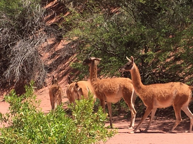
The coolest part was when we came upon a herd of guanaco. Not only was it the first guanaco that I see in the wild, we were right there close to them, in their natural habitat! They let us get about 20 feet away before they finally ran off.
I think the thing that impressed me the most was that we could see where a fault line passed because there was a huge diagonal crack in the walls of the canyon on both sides.
Our guide drew a 24-hour clock in the sand and explained that if the history of the Earth were compared to one day, where the Earth formed at midnight, life appeared at about 3-4am, and the rock formations in the park (that formed 250 million years ago) formed at just one minute and 30 seconds until midnight at the end of the day! (We humans appeared at about 6-10 seconds until the end of the day!)
I stood in awe, with the beautiful, 250 milion-year-old canyon walls towering above me. I felt so tiny and at the same time I felt that I was traveling time, and through that time travel I was connecting to the extensive history of this planet, and somehow that made me both tiny and as big and as old as the planet, all at the same time.
When I got back from the hike that afternoon, it was time for that character-building activity of asking for a lift to Baldecitos, the little town near the entrance to the provincial park Ischicualasto. It shouldn’t seem like a big deal, but for a person raised in the US and raised to be self-sufficient and independent, it is a bit of a psychological challenge. One has to overcome embarrassment, shyness, and fear of rejection, all at once. So I set myself up near the parking lot and asked all the people who drove up where they were headed, and if they were going my direction if they would have room for one more person. About 5 different cars arrived and everyone was very friendly in their rejection, but they were not going my direction.
As one of the excursions returned, I found an older couple that was headed that direction and they were happy to give me a ride. The woman, Ana, was in her 60’s and she is a psychologist in Buenos Aires. They were at the end of their vacation and she had to get back to work after the holidays. She had a private practice and then also worked with the government to do psychological evaluations for people applying for commercial drivers’ licenses. She talked about how she had backpacked through Europe when she was younger and continued to travel as much as possible. They were then kind enough to go a few minutes out of their way to drop me off in Baldecitos, waiting to make sure I found a place to stay.
The woman who owned the hospedaje en Baldecitos was about my age and she lived next door with her little boy of about 12-13 years old. After I got settled in, I saw she was outside spraying the ground with a water hose to control the dust, and I came out and asked her about life in Baldecitos. She was a farmer, with milk and beef cows and also received some extra income from tourists passing through for the park. She was born and raised there in Baldecitos, which has just about 10-15 families living there permanently, with maybe up to 25-20 houses total! (Definitely the smallest town I’ve been in so far.)
A few months prior, they had constructed a cell tower in the town that was also supposed to also bring wi-fi for the community, but it was really spotty, with some of my whatsapp messages delaying a few hours to send.
I feel at home anywhere if I can do yoga with the sunset.
There was a “comedor” (small, simple, family-style restaurant) near my hospedaje where I went to see if I could get something to eat. While there, an older French couple came in also asking about dinner and about logistics for going to the park the next day. The man and older woman in the comedor told us they would serve dinner at 9pm, and that the park opened at 8am and was about 12km down the road.***
This park – Ischigualasto – is the park that you visit by driving through, caravan style, with a guide, stopping along the way to see certain parts. (I had read on blogs that many people without their own transportation look for other people to give them a lift through the park.) The couple seemed really nice and friendly, so I took that opportunity to ask if they had room for one more person, and they assented and said we could chat over dinner.
Over dinner I learned that they had rented a car and were driving down La Ruta 40, with destination Bariloche, but looking for cute little towns and beautiful, hidden gems along the way, just like me (except with a car). They already have grown kids, but they also have this beautiful child-like energy, getting really excited about the places they’ve seen and what there is to see ahead. My kind of people. We hit it off immediately and agreed to meet at 8am the next morning to go explore the Parque Ischigualasto together.
Footnotes:
* Dario (the park guide whose house I had stayed at in Pagancillo the night before) had assured me that many people go between the two parks and that I wouldn’t have a problem finding a ride from Talampaya to Ischigualasto. Since that was consistent with the blogs I’d read on the internet, I felt good about the plan.
**I like to know all the options before I make a choice, and here it took me about an hour to understand how it all works (and that’s after having done research online!) It turns out that this is only one of two different park entrances for the National Park Talampaya. At this entrance, there are two companies – one that offers excursions in jeep that leave on a set schedule every few hours, and another that offers hiking or biking excursions. It is all very confusing because the company that offers jeep excursions is also in charge of selling the Park Entrance fee, which makes it seem like their excursions are the only options. But if you ask around, you find that there’s a small office around the corner that offers hikes and bike rides if enough people are interested in forming a group. As a third option for exploring the park, there is another park entrance about 10km down the road, where a different company offers an excursion in jeep to see another part of the park called “Cañon Arco Iris” (Rainbow Canyon) and “La Ciudad Perdida” (Lost City). I also heard that there is another company forming that will do excursions to another part of the park next year.
***I chatted for a while with the couple in the comedor in Baldecitos asking them about life in Baledcitos. They presented another point of view about the park. They said that while they weren’t completely opposed to the park and tourism from the park did bring some income, they were kind of frustrated that it put restrictions on their ability to raise animals because it was a protected area (and to prevent accidents with the passing cars). They mentioned that would have liked to maintain the practices of their ancestors in the raising of guanaco and cattle in the wide open spaces. They also said that this provincially-managed park doesn’t provide the same job opportunities for people in the community of Baldecitos, like the nearby national park Talampaya which provides jobs for many people of the nearby town Pagancillo. They did mention that a consultation process was used to create the park, but they felt that their opinion was not considered. (The complexity of the situation was not lost on me, since I am reading about Latin American history during my travels. For example, I confirmed that they were specifically referring to their European ancestors who have inhabited those lands for hundreds of years. If you keep going back in time, you come to a point in time where their ancestors usurped the lands of the indigenous people living there. And maybe those indigenous people usurped the lands from someone before them.)
The Atacama desert in northern Chile is known for the best stargazing in the world – and that’s why I HAD to come here. Ironically, I came during the two weeks of the year when it was cloudy and I didn’t get to do proper stargazing (other than a few minutes before the sunrise one morning.)
But, the sunsets!!! Even if I didn’t get to see the other suns of the universe, I got to see OUR sun in all its glory!
The dry desert air makes the incredible landscapes look exceptionally majestic and brilliant, and with a setting sun sending gold in all directions and casting deep blue shadows while tinting the clouds in pink, one will stop whatever she or he’s doing and run to catch the sunset every evening.
All the sunsets were awesome, but the most incredible was definitely in Laguna Tebinquinche*, where the sun set over the white, salt-covered lake and a rainbow emerged in the dark blue rainclouds opposite the sun.
Like many lakes here, the water appears to be covered in a layer of ice but is actually encrusted with a layer of white salt. The lakeshore is filled with “living rocks,” which are salty rocks made up of minerals and microorganisms that can survive some of the harshest environments on the planet. These microorganisms are some of the first living things that came into existence on Earth!
Contemplating the first life on earth, a flamingo flies across the sunset. And with friends made along the journey, we marvel at the beauty of life, the richness of the moment. We all just met each other, and yet we’re all family, born from Mother Earth, who is amazing us with her beauty.
But I digress. Being immersed in this vast desert, looking out across immense spaces and also out into the vast sky, makes one reflect on the grandness of the Earth, the universe, and the beauty of life.
While access to sensitive spots is limited to protect them, there was one salt lake that people can swim in. If you have never swam in a salt lake before, it’s definitely worth adding to the bucket list. Because salt water is more dense than fresh water, the saltier the water the more we float. I noticed the difference swimming in the Pacific Ocean in Lima, but it still didn’t compare to the unique sensation of floating in the salt lake in Atacama!
Look Ma! No hands!
When a large moist area of salty land has dried up, a salt flat (“salar”) is left behind. I saw many salt flats, with the the Salar de Atacama being the 3rd largest salt flat in the world (after those in Uyuni and Argentina). It is so large it can be seen from space.
I was lucky enough to see a few other marvels of the desert during my stay in Atacama, the most grandiose being the National Reserve of the Flamingos (Reserva Nacional de los Flamencos). At 4,200 meters (13,800 ft) above sea level, we saw two beautiful mountain lakes that used to be one great lake until seismic activity of the Nazca and South American tectonic plates created some hills that divided the lake in two.
Another breath-taking desert lake is the laguna aguas calientes. Here, the diversity of the landscapes was overwhelming. There were huge dune-like mountains of black lava rock, a lake of hot water fed by an aquifer that sits on top of a volcanic magma layer, and red hills rich in iron minerals. All accented by the pink flamingos looking for food in the lake below.
Finally, the bike ride through the Valle de la Luna was a challenging adventure through the desert heat, where we met friends along the way, saw incredible rock formations, and watched rain develop across the flat desert plains – the same rain that cooled us off a few hours later.
One final fun fact. The Atacama desert is located on the tropic of capricorn. I’m pretty sure I learned about the tropic of Capricorn at some point in my life, but I didn’t really remember what it was. The tropic lines are the points where the sun shines directly overhead, due to the tilt in the Earth. The regions of land between the two tropic lines are considered “tropical” areas since they receive the most direct sun, typically creating warmer year-round climates than the rest of the globe.
Our guide explains the tropic lines with a drawing in the desert sand. The sign marks where the tropic of capricorn passes, which also happens to be a part of the Inca Trail.
Famous Footnotes
Unless you rent (or have) a car to go see the sites (which would be a great way to explore Atacama), the way to see things is through the tours offered by the various tour companies in San Pedro de Atacama. The tours I took were:
-Tour 1: Laguna Cejar, Laguna Piedra (the salt lake where you can swim and float), Ojos del Salar, and Laguna Tebinquinche (the salt lake with the amazing sunset).*If you take the tour of Laguna Cejar in the afternoon, it usually ends at Laguna Tebinquinche so you can see the incredible sunset here.
-Tour 2: Reserva Nacional de los Flamencos (Laguna Miscanti and Laguna Miñiques), Laguna Talar, and Salar and Laguna Aguas Calientes with overlook to Piedras Rojas
-Observatory ALMA tour (free but you have to get to the meeting point early to get on the list, as I described in my blog post.)
-I rented a bike and rode through “Valle de la Luna” all day (about 6 hours), and another afternoon I rode through “Valle de Marte” and watched the sunset from an overlook point nearby.
**I didn’t get to do a stargazing tour because of weather, but would definitely recommend one!
**I didn’t get to do the geyser tour because rain had washed out the road, but would also recommend that!
I kept hearing and reading that Salento and the Cocora Valley are “the place(s) to go” in the Eje Cafetero, (coffee region) of Colombia. Was Salento in the Cocora valley? Or nearby? I wasn’t really sure so I headed there to find out.
The bus trip to Salento from Manizales was captivating as we wound through the beautiful green mountains. Nearing the other major city of the “eje cafetera”, Pereira, I took in the spectacular view looking down on the highway carved along the side of the majestic verdant mountains, leading to the city below. While to some extent it reminded me of traveling to Oxapampa, (Peru) it had a slightly different feel because of the shapes of the hills. (Sorry couldn’t get a good photo op!)
From Pereira I caught a van to Salento, which turns out to be a cute, tiny town (Colombia is full of them!) that has the steepest streets I’ve ever seen – more so than Manizales or La Paz! Or was it an optical illusion because Salento is so small – only about 10 blocks long in either direction? Like Guatapé, almost every house was painted a beautiful combination of two or three colors.
I learned that Cocora is another town – even smaller and more rural than Salento, located about 13km from Salento – and it is the starting point for exploring the Cocora valley. I decided to bike from Salento to Cocora and then hike around when I got there.
One can hike in (a multi-hour hike) and spend the night in the valley, or one can explore parts of the valley on horse-back or hiking during a day trip. Chatting with a local woman selling artisan goods (and access to bathrooms), I learned that the “palmera de cera” (wax palm) – a tall, skinny palm that rises so tall it stands out among all the other trees in the landscape – is unique to the region and one of the main reasons the area is a (mixed use) protected area.
Though you can see from the landscapes, that the land is also used for grazing, (for milk and cheese production),** the main economic activity in Cocora is tourism (which has been big for about 30 years!) The town sees more international tourists than Colombians (probably because many tourist companies sell packages for tours through Colombia including a stop in Cocora.) Most of the guides and vendors are from Cocora, with a few from Salento, and the woman I was chatting with opined that while tourism helped the economy in some ways, it wasn’t a magic bullet making everyone wealthy because it also caused the price of land and goods to rise.
I didn’t hike in to spend the night in the Cocora Valley and I also didn’t stay in the town of Salento. Instead, I stayed a 20-minute walk from Salento for a countryside experience in a chill hostel called Yambolombio that I had found on the interwebs. I arrived at night and was greeted by a family home-like atmosphere, with travelers from Europe and Australia chatting in the living room, eating at the dining room table, and the owner preparing his dinner in the kitchen. I was introduced to the finca’s two dogs and the horse while I was shown to the shared dorm space out back.
The property was on the side of a tall, steep hill, and the only flat space was found climbing up to the top of the hill, where there was a fire ring for campfires and perfect small, open space for doing yoga. Every night I fell asleep to the sounds of night insects on the background of a peaceful silence, and every morning I climbed to the top of the hill to greet the sunrise while doing yoga and listening to the river in the valley below. I can see why this is a popular stop for both international tourists and Bogatanos looking to escape city life.
Famous Footnotes:
*There are actually a ton of cute little towns around the area, and any one of them is worth checking out or staying in.
**The local woman explained to me that they don’t produce a lot of cheese there in Cocora, rather the surrounding areas produce more. There are some cheeses that they can only buy once a month because the producers live so deep in the hills that it takes a whole day by mule on dirt paths to get into Cocora to sell their products.


 I learned that Cocora is another town – even smaller and more rural than Salento, located about 13km from Salento – and it is the starting point for exploring the Cocora valley. I decided to bike from Salento to Cocora and then hike around when I got there.
One can hike in (a multi-hour hike) and spend the night in the valley, or one can explore parts of the valley on horse-back or hiking during a day trip. Chatting with a local woman selling artisan goods (and access to bathrooms), I learned that the “palmera de cera” (wax palm) – a tall, skinny palm that rises so tall it stands out among all the other trees in the landscape – is unique to the region and one of the main reasons the area is a (mixed use) protected area.
I learned that Cocora is another town – even smaller and more rural than Salento, located about 13km from Salento – and it is the starting point for exploring the Cocora valley. I decided to bike from Salento to Cocora and then hike around when I got there.
One can hike in (a multi-hour hike) and spend the night in the valley, or one can explore parts of the valley on horse-back or hiking during a day trip. Chatting with a local woman selling artisan goods (and access to bathrooms), I learned that the “palmera de cera” (wax palm) – a tall, skinny palm that rises so tall it stands out among all the other trees in the landscape – is unique to the region and one of the main reasons the area is a (mixed use) protected area.

 Though you can see from the landscapes, that the land is also used for grazing, (for milk and cheese production),** the main economic activity in Cocora is tourism (which has been big for about 30 years!) The town sees more international tourists than Colombians (probably because many tourist companies sell packages for tours through Colombia including a stop in Cocora.) Most of the guides and vendors are from Cocora, with a few from Salento, and the woman I was chatting with opined that while tourism helped the economy in some ways, it wasn’t a magic bullet making everyone wealthy because it also caused the price of land and goods to rise.
 I didn’t hike in to spend the night in the Cocora Valley and I also didn’t stay in the town of Salento. Instead, I stayed a 20-minute walk from Salento for a countryside experience in a chill hostel called Yambolombio that I had found on the interwebs. I arrived at night and was greeted by a family home-like atmosphere, with travelers from Europe and Australia chatting in the living room, eating at the dining room table, and the owner preparing his dinner in the kitchen. I was introduced to the finca’s two dogs and the horse while I was shown to the shared dorm space out back.
The property was on the side of a tall, steep hill, and the only flat space was found climbing up to the top of the hill, where there was a fire ring for campfires and perfect small, open space for doing yoga. Every night I fell asleep to the sounds of night insects on the background of a peaceful silence, and every morning I climbed to the top of the hill to greet the sunrise while doing yoga and listening to the river in the valley below. I can see why this is a popular stop for both international tourists and Bogatanos looking to escape city life.
I didn’t hike in to spend the night in the Cocora Valley and I also didn’t stay in the town of Salento. Instead, I stayed a 20-minute walk from Salento for a countryside experience in a chill hostel called Yambolombio that I had found on the interwebs. I arrived at night and was greeted by a family home-like atmosphere, with travelers from Europe and Australia chatting in the living room, eating at the dining room table, and the owner preparing his dinner in the kitchen. I was introduced to the finca’s two dogs and the horse while I was shown to the shared dorm space out back.
The property was on the side of a tall, steep hill, and the only flat space was found climbing up to the top of the hill, where there was a fire ring for campfires and perfect small, open space for doing yoga. Every night I fell asleep to the sounds of night insects on the background of a peaceful silence, and every morning I climbed to the top of the hill to greet the sunrise while doing yoga and listening to the river in the valley below. I can see why this is a popular stop for both international tourists and Bogatanos looking to escape city life.
