For three years I called Peru home while I served in the U.S. Peace Corps nearly 10 years ago. This year, I find myself back in Peru for many months, traversing some of those same highways, busy city streets, dirt roads, and bike routes. But I am also discovering new corners of this beautiful country, meeting new people, and believe it or not, I am still discovering new food!
When you think of Peru, what do you think of? (Without looking at your phone… No Google. No AI.)
The most common responses I’ve gotten from US citizens are: Machu Picchu and llamas. A few people might remember that Lima is the capital. And fewer still might think of Lake Titicaca, which shares its beaches with both Peru and Bolivia. Foodies might have heard that Peru is the “World’s Leading Culinary Destination,” a title it has won multiple times, including in 2023 and 2024.
Ask a Peruvian about Peru, and they often mention the food first. Every new Peruvian I meet always wants to know if I like the food and “what is my favorite dish?” (They are also usually surprised that my answer isn’t lomo saltado, ceviche, pollo a la brasa, or one of the common dishes served in a restaurant Lima. Rather, my favorite dish is something their mom or grandmother would cook regularly at home, called locro de zapallo.)
If it’s not the food, Peruvians (and visitors to Peru) are likely to define Peru as a country known for its rich variety of different (and very beautiful) landscapes, climates, and cultures, which are generally categorized into three regions: coast (la costa), mountains (la sierra), and jungle/rainforest (la selva).
The coast (which is along the Pacific Ocean) has mostly desert landscapes and of course the cuisine is dominated mainly seafood (Peruvian ceviche, arroz con mariscos, and more!) The desert landscapes quickly rise in altitude, turning into the Andes mountains (la sierra) as you travel east from the coast. The sierra is where the llamas and the more than 4,000 varieties of potatoes are from. And as you continue east, down the other side of the Andes, you arrive in the jungle (la selva), the edge of the Amazon rainforest, rich in biodiversity and diversity of indigenous cultures and languages.
Costa / Sierra / Selva
I have been lucky to live and work in central Peru – “The Selva Central”. That means that as I travel to and from the capital, I have the opportunity to cross all three major regions. The landscapes are ever-changing and breathtaking. Though thousands of people do it every day, it’s not for the weak of heart. Crossing the Andes means winding up to 4,818 meters above sea level (15,800 feet), and then back down again. It means traveling from the damp coast to the cold mountains, through the humid jungle, and winding back up to the high jungle, or the “ceja de la selva”. If you can handle a 12-hour bus ride or 8 hours of changing cars a few times “en escala” by “collectivo”, it is well worth the experience!
I will continue to share my experiences diving below the surface and exploring some of the beautiful nooks and crannies of Peru. In the meantime, here are some photos traversing from la costa, to la sierra, to la selva. Can you guess which region each is from?
Answers (from top left to right): 1. between the coast and sierra 2. Coast 3. Between coast and sierra 4. Coast 5. between the coast and sierra 6. sierra 7. sierra 8. between the coast and sierra 9. between the coast and sierra 10. sierra 11. sierra 12. jungle 13. jungle 14. jungle 15. sierra (between sierra and jungle) 16. sierra (end of rainy season so it’s green) 17. between the coast and sierra 18. between the coast and sierra 19. between the coast and sierra 20. between the coast and sierra 21. between sierra and jungle (end of rainy season so it’s green)
The “Camino de los Siete Lagos” (or 7 Lakes Route) supposedly ends (or begins) in Villa de la Angostura, but continuing south you will find the popular ski and hiking city of Bariloche on the southern side of the beautiful lake Lake Nahuel Huapi. Located within the National Park with the same name (Parque Nacional Nahuel Huapi), Bariloche is situated on the lake and surrounded by beautiful forests, mountain-like hills, streams, and other lakes – a paradise for hikers, rock climbers, kayakers, wind surfers, and anyone who loves to visit the outdoors and see breath-taking landscapes.
Besides being blown away by its amazing lakeshore view, my first impression of Bariloche was that it reminded me of Boulder, Colorado. I guess I wasn’t too far off because I was told it’s sister cities with Aspen. On one hand, the local feel was that it was full of outdoor enthusiasts and also had a pretty big hippy-like culture. At the same time, it was very much a tourist town,* with streets lined with businesses of all kinds, but a very notable amount of outdoor clothing and equipment shops, tourist information, health food stores, and chocolate shops. That’s right, Bariloche is also known across Argentina not only for its skiing but for its chocolate!
The city extends along the southern side of the lake Nahuel Huapi for about 20 km towards the peninsula and the city park Llao Llao, with unlimited beautiful sites to see along the way. Some of the most popular include visiting beaches along one of the lakes, climbing to the top one of the many hills that offer incredible views of the area, hiking through different trails in the park or around the lakes, visiting an old Swiss colony, or just exploring the city center.
I happened to arrive for International Women’s Day, so there was a march through the city, ending in the plaza (which looks out over the lake). I caught the end of it in the plaza when there were still around 100 people – men, women, and children – gathered, holding banners and signs, wearing green handkerchiefs,** and cheering as speakers spoke about the progress that had been made in human rights and the set-backs and modern-day challenges that Argentina faced currently. While the focus was on women’s rights and issues – domestic violence, freedom to legal and safe abortions, equal opportunities and pay – I was impressed that they chose to be inclusive and talk about basic human rights in general, bringing attention to injustices harming indigenous communities, impoverished communities, and LGBT+ persons.
The days were beautiful, with full sunshine that felt like summer during mid-day and cooled off quickly when the sun started to go down. There was always an energy buzzing as the streets, parks, beaches, and buses (“colectivos”) were full of people out to enjoy the outdoors – many that lived in the area but also a ton of people on vacation from Buenos Aires. The great thing about Bariloche is there are a ton of day hikes you can do and places you can visit and enjoy in just one day or a half day. But there are also a few overnight hiking and camping adventures, like Refugio Frey or climbing El Cerro Tronodor, which is on the border with Chile.
I barely got a chance to scratch the surface of all the popular places to visit, but each day I hopped on the city bus to go explore a new place.
First, I headed off to Cerro Campanario, where, (similar to Monserratte in Bogotá and Cerro San Bernardo in Salta), there was a teleferico (ski-lift-like cable car) that you could take up to the top of the hill overlooking the city.
Or, you could take the walking path and hike up to the top. (It was in this hike, where I ran into my friends the San Juaninos, Liliana and Edgardo!)
From the top, there was almost a 360-degree view of Lake Nahuel Huapi on one side, and the hills, forest and other lakes on the other side.
There was a beautiful overlook point with chairs, where people were sitting and staring out over the lake, just drinking in the beautiful view. A family came, and the mom had prepared a cake and pretended to sell it to her three kids, “charging” them each a few pesos.
Another day, I took a 40-minute bus ride out to the Municipal Park Llao Llao, about a 20-minute walk from the last bus stop where they leave you at Hotel Llao Llao.
There are a ton of trails in this park and you could spend all day exploring all the different nooks and crannies or just take a leisurely hike along one of the trails.
I spent most of the day walking around Lago Moreno, and incredibly serene and gorgeous lake that I just couldn’t stop taking photos of.
Interestingly enough, I would be spending about a month in quarantine at the opposite end of this lake (not visible from where I was because it is quite large).
Famous Footnotes:
*A huge part of the economy is based around tourism, including the winter ski season. Many friends I met were guides.
**The green bandana is a symbol representing women’s rights and specifically a call for safe and legal abortion as an option for women. As I mentioned in a previous post, it is currently a hot topic and many people brought it up in conversations we had.
I woke up early that morning in “Baldecitos”*, not really sure where I would be sleeping that night.
The French couple I had met, Silvia and Michel, were going to pick me up at 8am to tour the famous Parque Ischigualasto together, so I was pretty excited about that! (I would get a chance to get to know them, and I had overcome the challenge of seeing the park without my own car!)
But after that, my future was uncertain. I was learning to get comfortable with taking things day by day. Sometimes even hour by hour.
(In my travels, I keep a spreadsheet of dates and locations, transportation times and costs, etc., but it is more like a rough guide than a fixed plan. And the last few days I had really be improvising, especially as I’d discovered cute small towns and these national parks! Squirrel!)
A few minutes before 8am, I headed outside and found a car parked out front where we’d agreed to meet. As I approached, I was greeted by the bright smiling faces of Silvia and Michel, and I was happy to join the excited energy of heading off for a new adventure.
When we arrived at the park we were instructed that we would be joining a caravan of about 5 other vehicles, with the guide at the helm, and we would be stopping at certain spots along the way where we would get out, walk a short way, and the guide would share information with us.
Silvia and Michel, my French friends, in front of a large “mushroom” formation, a common formation seen in Parque Ischigualasto.
At the first stop, we parked behind a white van with Texas plates. I rubbed my eyes and looked again, but it was true that I wasn’t dreaming.
After checking out the landscapes of the “valle de la luna”, I heard a couple my age speaking in English and heading towards the van. Too shy to talk to them, I never learned if they were really from Texas.
Just kidding. If you believed that, you haven’t been reading my blogs enough to know that I’m rarely too shy to talk to someone.
So, it was there in the middle of Argentina, where I met Danika and Brady, a couple that had been living in El Paso, Texas and had been planning to travel through South America. A little over a year ago, their plans started coming together and they decided to do the journey by land from Texas to the southern tip of South America. They bought a van and turned the back part of it into a mini-apartment – equipped with a bed, shelves, cabinets, a stove, and even with walls decorated with photos – and then began their journey south. And now, we had been lucky enough to cross paths here in Parque Ischigualasto!
Parque Ischigualasto was quite a gem, with fossils from as far back as the Triassic Period – 250 MILLION years ago – when Pangea existed! (Remember Pangea? Back when the majority of the continents were united as one continent.)
So the parks (Ischigualasto and Talamapaya) are UNESCO World Heritage sites because they help tell the story of the evolution of land and life on Earth across time.
With so much time on its hands, the Earth had done some pretty creative things. Like creating these perfectly-shaped spherical rocks.
Precariously balanced towers of rock.
That sometimes do topple over.
I saw where the ancient Egyptians got their idea for the Sphynx. (The natural world had already created it!)
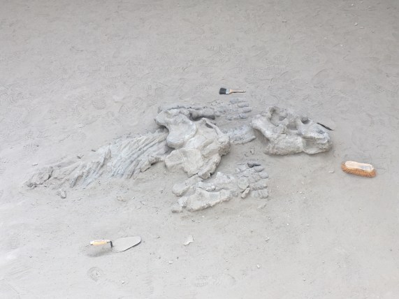
One stop included a museum where they told us about the dinosaurs and fossils that have been found in the area (many dinosaurs have been found in Argentina!) They explained how they carefully excavate fossils and determine their age (carbon dating), how they determine where they should dig to look for interesting things, and how they try to understand the geological processes that cause changes across the millennia.
The final stop was a showcase of the rock formations in their different stages of evolution, so you could essentially see the process that leads to the creation of the mushroom formations, as it happens over thousands of years.
We promised to come back to see these formations when they are mushrooms in a few thousand years.
Loving my time with Michel and Silvia and having also made two new friends, Danika and Brady, I realized that as a group of 5, we could do the tour of “cañon arco iris” and “ciudad perdida” (Rainbow Canyon and Lost City). (This is the tour that leaves from the southern entrance of Parque Talampaya and leaves only if a group forms.) They were all interested in the idea, so instead of trying to head to San Juan, I continued on with them, back towards Parque Talamapaya.
On the way, Silvia, Michel, and I shared travel stories and talked about everything under the sun. I learned that Michel had actually been to Talampaya before, more than a decade ago, before it was a national park. At that time, he had been able to drive his vehicle through the park to see the sights. Now only the tour companies are permitted to drive in the park, to minimize the human impact.
Michel had a project collecting photos of all the different animal crossing signs they saw along the way, so I took advantage and joined in the game – which also included trying to spot all the animals from the signs.
From top left, clockwise: Ostrich, Guanaco, Liebre, Fox
We arrived at the ArcoIris entrance to Talampaya just in time to be able to do an afternoon tour, and we even picked up an extra for the group – Alicia, a woman from Mar de Plata (a city in Argentina) that was on vacation traveling by motorcycle. (We also greeted a French cyclist passing through, brave or crazy enough to be cycling through the desert.)
The hike through Cañon Arco Iris and Ciudad Perdida was time travel through millions of years. We started with the red “youngest” rock formations and as we walked along we passed through tens of millions of years, finally arriving at the grey oldest rock formations, named “Ciudad Perdida” because of their shapes.
Leaping across tens of million of years, into Ciudad Perdida
Along the way, we could see how the seismic activity that created the Andes had lifted parts of earth’s crust out of the ground, exposing different layers of rock.
And we could see how the sun, wind, and rain changes the rock over millions of years, turning it into sand and reshaping it.
We also saw where the Incas might have gotten their idea for using rectangular stones for building walls that could withstand seismic activity…right there from nature herself.
You know when you meet someone that is so passionate about something that even if you never were interested in the topic before, they transmit their energy and enthusiasm to you and ignite an interest in you? (I’ve had some really good teachers with this talent, for example.) Well, our guide was like that. He was an easy-going and soft-spoken person, and when he talked about the the rocks and plants in the park and the history and science around it all, you could tell that he was really passionate about sharing this beautiful place with others (in his easy-going, soft-spoken kind-of-way).
Our guide Camilo lives in Pagancillo and the company that offers this tour is actually a co-op of independent guides, separate from the larger company at the main entrance of the park.
We finished the tour in the evening, and luckily, Silvia and Michel also loved staying in small towns, so I was happy to have already scouted out Pagancillo, the small town near the park. And I was really happy to be returning there to be able to see the friends I had made there, Dario and Marisel, once again.
That night, sharing wine and grapes (from their grape vine) with the family, the stars were shining brightly and it was a perfect opportunity to bust out the stargazing app and look at the stars. They were fascinated, as they hadn’t had the constellations pointed out to them before. So even though I was exhausted from a long day (that started in Baldecitos and had the surprise ending of being back here in Pagancillo), we walked down to the river where there were no lights to see the night sky in all its glory.**
Famous Footnotes:
*Baldecitos is the small town of about 10 houses, that is about 15km from the entrance to Parque Ischigualasto.
**While I was impressed by the centaur, whose hind leg is made up of the southern cross (only visible in the southern hemisphere), they were more impressed by the dog Sirius and Virgo.
The Atacama desert in northern Chile is known for the best stargazing in the world – and that’s why I HAD to come here. Ironically, I came during the two weeks of the year when it was cloudy and I didn’t get to do proper stargazing (other than a few minutes before the sunrise one morning.)
But, the sunsets!!! Even if I didn’t get to see the other suns of the universe, I got to see OUR sun in all its glory!
The dry desert air makes the incredible landscapes look exceptionally majestic and brilliant, and with a setting sun sending gold in all directions and casting deep blue shadows while tinting the clouds in pink, one will stop whatever she or he’s doing and run to catch the sunset every evening.
All the sunsets were awesome, but the most incredible was definitely in Laguna Tebinquinche*, where the sun set over the white, salt-covered lake and a rainbow emerged in the dark blue rainclouds opposite the sun.
Like many lakes here, the water appears to be covered in a layer of ice but is actually encrusted with a layer of white salt. The lakeshore is filled with “living rocks,” which are salty rocks made up of minerals and microorganisms that can survive some of the harshest environments on the planet. These microorganisms are some of the first living things that came into existence on Earth!
Contemplating the first life on earth, a flamingo flies across the sunset. And with friends made along the journey, we marvel at the beauty of life, the richness of the moment. We all just met each other, and yet we’re all family, born from Mother Earth, who is amazing us with her beauty.
But I digress. Being immersed in this vast desert, looking out across immense spaces and also out into the vast sky, makes one reflect on the grandness of the Earth, the universe, and the beauty of life.
While access to sensitive spots is limited to protect them, there was one salt lake that people can swim in. If you have never swam in a salt lake before, it’s definitely worth adding to the bucket list. Because salt water is more dense than fresh water, the saltier the water the more we float. I noticed the difference swimming in the Pacific Ocean in Lima, but it still didn’t compare to the unique sensation of floating in the salt lake in Atacama!
Look Ma! No hands!
When a large moist area of salty land has dried up, a salt flat (“salar”) is left behind. I saw many salt flats, with the the Salar de Atacama being the 3rd largest salt flat in the world (after those in Uyuni and Argentina). It is so large it can be seen from space.
I was lucky enough to see a few other marvels of the desert during my stay in Atacama, the most grandiose being the National Reserve of the Flamingos (Reserva Nacional de los Flamencos). At 4,200 meters (13,800 ft) above sea level, we saw two beautiful mountain lakes that used to be one great lake until seismic activity of the Nazca and South American tectonic plates created some hills that divided the lake in two.
Another breath-taking desert lake is the laguna aguas calientes. Here, the diversity of the landscapes was overwhelming. There were huge dune-like mountains of black lava rock, a lake of hot water fed by an aquifer that sits on top of a volcanic magma layer, and red hills rich in iron minerals. All accented by the pink flamingos looking for food in the lake below.
Finally, the bike ride through the Valle de la Luna was a challenging adventure through the desert heat, where we met friends along the way, saw incredible rock formations, and watched rain develop across the flat desert plains – the same rain that cooled us off a few hours later.
One final fun fact. The Atacama desert is located on the tropic of capricorn. I’m pretty sure I learned about the tropic of Capricorn at some point in my life, but I didn’t really remember what it was. The tropic lines are the points where the sun shines directly overhead, due to the tilt in the Earth. The regions of land between the two tropic lines are considered “tropical” areas since they receive the most direct sun, typically creating warmer year-round climates than the rest of the globe.
Our guide explains the tropic lines with a drawing in the desert sand. The sign marks where the tropic of capricorn passes, which also happens to be a part of the Inca Trail.
Famous Footnotes
Unless you rent (or have) a car to go see the sites (which would be a great way to explore Atacama), the way to see things is through the tours offered by the various tour companies in San Pedro de Atacama. The tours I took were:
-Tour 1: Laguna Cejar, Laguna Piedra (the salt lake where you can swim and float), Ojos del Salar, and Laguna Tebinquinche (the salt lake with the amazing sunset).*If you take the tour of Laguna Cejar in the afternoon, it usually ends at Laguna Tebinquinche so you can see the incredible sunset here.
-Tour 2: Reserva Nacional de los Flamencos (Laguna Miscanti and Laguna Miñiques), Laguna Talar, and Salar and Laguna Aguas Calientes with overlook to Piedras Rojas
-Observatory ALMA tour (free but you have to get to the meeting point early to get on the list, as I described in my blog post.)
-I rented a bike and rode through “Valle de la Luna” all day (about 6 hours), and another afternoon I rode through “Valle de Marte” and watched the sunset from an overlook point nearby.
**I didn’t get to do a stargazing tour because of weather, but would definitely recommend one!
**I didn’t get to do the geyser tour because rain had washed out the road, but would also recommend that!
The Atacama desert is the driest and highest in the world, and that’s one of the main reasons that we built “ALMA,”* the largest radio telescope in the world here! I say “we” because it was an international collaboration – an example of us humans working together to better understand the universe in which we live.
“The purpose of ALMA is to study star formation, molecular clouds and the early Universe, closing in on its main objective: discovering our cosmic origins.”
To most of us, a telescope is an apparatus of lenses pointed at the sky to see stars, (or far away visible light in the sky). But the ALMA telescope is not one, but 66 antenas pointed at the sky! Just like we have 2 eyes that give us a single image of the world, the telescope has 66 eyes to give us a single image – it’s like a mom that has eyes in the back of its head. Or like a fisheye camera.
The other unique thing about the ALMA telescope is that it isn’t viewing light in space like an optical telescope, it’s looking at the dark and cold part of space, capturing radio waves* emitted by stars and planets.
One of the antenas undergoing maintenance
That doesn’t mean that stars and planets are broadcasting songs. Radio waves are emitted by the cold and cool matter in the universe that doesn’t give off light and so can’t be seen with our eyes (or with optical telescopes). But the ALMA telescope can receive these signals and tell us about that matter out there in space.
For example, the ALMA telescope was able to detect sugar molecules around a young sun, indicating a good possibility for a life-supporting planet to develop in that solar system.**
In some cases, scientists can combine the information from an optical telescope and ALMA (and x-ray and infrared telescopes)* to give a fuller picture of a solar system or galaxy, and to “see” what’s happening in the dark spots of the sky.
Also, since it’s not optic, ALMA can point at the sun and study the sun’s atmosphere without burning.
For me, one of the most interesting abilities it has is to study the early universe – it has found evidence of the earliest known solar system – suns that formed just 250 million years after the Big Bang. (Sounds like a long time, but it’s only 2% of the universe’s current age, which is about 13.8 billion years.)
I know, this is a lot of high tech modern science stuff. But according to our guide, the basic principle behind the antena design is actually something that was used hundreds of years ago by the pre-Incan culture, the Tihuanacu.
Just outside of La Paz, you can visit an archeological site of the Tijuanacu. Then you can head a thousand miles south to the ALMA observatory in northern Chile to see the modern day use of this technology studying the origins of the universe!
While the tour to the observatory is free, it takes a bit of luck to get there. To be on the official list you have to reserve online, usually 6 months to a year in advance. If you don’t make the official list, you might be able to get on the online waitlist. But since the list fills up so far in advance, a lot of people on the list end up not making it on the dates they reserved. So you still have a chance to get on the “hope list” the day of the tour. The bus leaves at 9am, but people show up sometimes 2 hours early to wait in line to be on the “hope list”. If there are any empty spaces from people who didn’t show up from online reservations, next priority goes to the wait list and then to the hope list, in order of arrival. It makes it that much more exciting to get chosen from the hope list! It’s like winning the lottery!
Famous Footnotes
*The ALMA – Atacama Large Millimeter/submillimeter Array – captures electromagnetic radiation with wavelengths in the range of milimeter wavelenths in the electromagnetic spectrum.
(There are also other non optical telescopes that exist- infrared and X-ray telescopes that capture information from other non visible light parts of the electromagnetic spectrum.)
The diversity of landscapes in Colombia is amazing, and one of those unique gems is the Tatacoa Desert, not too far from Bogotá, in Huila.
All within 32,000 hectares, the desert-like landscapes are filled with more than 100 varieties of cactus, petrified wood, and other-worldly rock formations.
While the majority of the area is dominated by grey-ish colored rock formations, the Tatacoa makes a sudden drastic change to red rock formations, and so is referred to by its two parts – the red desert and the grey desert.
The intense sun and extreme heat is something that the locals try to avoid by relaxing in the shade at mid day, and with long sleeves and brimmed hats the rest of the day.
Fun fact: Despite it’s heat, sand, and cactus, the Tatacoa Desert isn’t actually categorized as a desert; it’s technically a “dry forest” climate zone. (Though it’s what a lay person would call a “desert”.)
It was here in the Tatacoa desert that I discovered my favorite berry in the world – the Chichatop. I have never tasted a more delicious fruit (and I LOVE strawberries and blueberries… but this one topped them all!) Sorry, I didn’t get a photo of my favorite berry, but I did get a photo of this edible fruit that grows in a cactus.
The desert is just a few minutes drive from the nice little town of Villavieja.* You can stay in the town and do a day trip to the desert, or you can spend the night at one of the hospedajes in the desert.
Many of them have pools (and even if you don’t stay in the desert, you an always pay to enter one of the pools for a much-needed cool-off).
On clear days you can see the faraway snow-capped mountains near Manizales, but these days you can’t see the white peaks. Due to global warming, the size of the snow caps has been diminishing over the years and they are too small to see now.
While a guide isn’t necessary to appreciate the desert, it is quite helpful to not get lost in the heat and to maximize your time seeing some of the highlights. I would recommend it especially in support of eco-tourism…it supports the local economy in a positive way, giving value to the preservation of the land and creating green jobs for the locals. Our guide specifically mentioned that he really loved the training he received to be a guide, learning about the landscapes and the history, and he hoped that he could continue to learn more to continue getting better at his job.
The Tatacoa is home to two observatories and they give viewing sessions every night where you can learn a few night sky fun facts and see a few highlights through a telescope and binoculars. I was super impressed to learn that the half moon is a C or a D shape in the US, but it’s more like a smile or frown shape here. (In other words, the we see the lit-up side from different angles so it seems to be rotated between the two hemispheres). Similarly, Casiopia is a “W” in the US but an “M” here (something I had noticed but just thought it was related to the time of the year I was looking at it!)
We looked at stars being born (in the Orion Nebula). And looking at the cloud of the andromeda galaxy, we saw more stars at one time than one sees in the entire sky. With a basic high powered telescope, binoculars, and a really knowledgeable star guide, it was interesting and entertaining, and I loved it! It was a perfect way to appreciate the desert night.
Famous Footnotes/Bonus Content:
*On the way back to Neiva, the largest city near Villavieja, I took a colectivo, which is like a taxi van that waits until all the seats are filled to leave. (I got lucky and was the last one so didn’t have to wait.) In the colectivo there was a couple from Bogotá, another backpacker from Europe, and two women from Villavieja. The women were quiet at first, but as we started chatting, they each had a fun sense of humor, and were very chill and friendly. They confirmed that the town is a pretty quiet and relaxed town, that lives off tourism and some farming and raising animals. That weekend was going to be less quiet than usual – the town was going to have a big celebration all weekend with a concert sponsored by the mayor.
I fell in love with Colombia – with the warm, friendly people, the neat and colorful little towns, and with the diversity of landscapes, climates and cultures. Across the country, in every place I stayed, I quickly felt at home.
(Podrías leer este publicación en español haciendo click aquí.)
The friendly and hospitable people and incredible diversity of landscapes wasn’t exactly new for me, because I have found it in abundance in every country in South America.
But each country has something special and its own unique flavor. Each country has those unique things that make it different from its neighbors, like an accent, certain words or phrases, customs, or trends. Colombia has its fair share, and I’m sure I only picked up on not even 10% of them, but here I’ll share a few that I noticed that made Colombia unique from the other South American countries I’ve visited. With these, you can start practicing so you can blend in as if you were from there!
In the streets…
Being a cyclist, I was fascinated by the number of people that ride bikes – both for daily commute and for exercise! I loved that in three of the cities that I visited, they opened “ciclovia” on Sunday mornings, where they closed of major streets to vehicle traffic, for cyclists, runners, or families that wanted to enjoy the morning walking in the fresh air.
Another two-wheeled novelty… I found that I could get around easily thanks to motorcycle taxis! I’m not talking about moto-taxis or “tuk-tuks” where they put a type of carriage for you to sit on the back of a motorcycle. Rather, you can flag down a motorcycle, just like you would a taxi, hop on the back, and get where you were going quickly and easily. (A few even insisted they had no problem taking me and my huge hiking backpack – and they really did carry me and my backpack just fine. Though I only rode with my big backpack in smaller cities at lower speeds!)
They even have an app like Uber or Lyft, called “Picap” where you can call the motorcycle taxi to come get you. (Everyone uses these apps (Uber, Beat, Picap), even though they are technically illegal.)
You can also see Chiva buses in many cities in Colombia. You’ll recognize them when you’re walking down the street and you suddenly hear the party coming down the road towards you. That’s right, they’re party buses that either go through the street picking people up (you can just hop on!) or some are contracted and you can rent the whole bus for your party.
I loved that there were a ton of outdoor parks, green spaces, and public parks throughout the cities I visited. There was usually outdoor exercise equipment, basketball and football (soccer) courts, playgrounds, and trails to walk or run. Especially in a big city like Bogota, it made it a lot more welcoming and livable, in my opinion.
I noticed graffiti art adding color to most cities, mostly with clear neighborhood or political themes (though also a few instances of gang-like tagging.)
Finally, I loved that there were water fountains in the airport, a sign that the country had advanced in providing potable water to taps for people. It turned out to be true that most of the places I visited did have potable water delivered to their taps!
There were also many different phrases, words and expressions that I noticed were different from the other countries I visited. One example was that after saying “thank you” for something, the common response not the “no problem” that I was used to, but rather “with pleasure”, which made one feel much more welcome. For more examples, read the Spanish version of this blog entry.
Finally, I was lucky enough to be in Colombia on December 7th when they celebrate “la noche de las velitas” or the night of candles. This is when families gather on their front porch or in the street outside their house to light candles. Each candle represents good wishes for a special person in their life. In Bogotá, many families or groups of friends gathered in public parks to sit in a circle and light their candles. It was a really lovely atmosphere where one felt a sense of community with others from the neighborhood, while enjoying a special moment with friends and family closest to you.
Me enamoré de Colombia, con su gente cálida, sus pueblos coloridos y ordenados y su diversidad de paisajes, climas y culturas. En varios lugares a través del país me sentí en casa y me acostumbré rápido al sitio nuevo y su gente.
En muchos sentidos, la gente acogedor y amable y la increíble diversidad geográfica no me fue nuevo, ya que son placeres que una encuentra en todos los países de Sudamérica. Cada país tiene su encanto y su sazón único.
Además, cada país tiene sus características únicas que lo distingue de los otros, que sea un dejo, palabras únicas, costumbres o tendencias. Colombia tiene suyos y seguro que yo solo capté ni siquiera un 10 por ciento de ellos, pero aquí te dejo un trocito de observaciones y diferencias que me sobresalieron de Colombia. Con esto, puedes comenzar a asimilarte al idioma y costumbres colombianos para que parezcas de allí al llegar.
Empezando en la calle…
Siendo una ciclista, me fasciné con la cantidad de gente que vi andando en bicicleta a diario. Además, en tres de las ciudades que conocí hacen “ciclovia” los domingos en la mañana (y posiblemente lo hacen en otras ciudades también). Tuve la suerte de estar en Bogotá, Medellín y Manizales cuando cerraron varias calles principales para los ciclistas, corredores, patinadores y familias que salen para caminar juntos para divertirse en el aire libre.
Otra novedad de dos llantas, es que en todos lados pude movilizarme fácilmente con taxi de moto linear. (No hablo de la moto taxi que tiene asiento con techo atrás del conductor, sino la motocicleta linear sola. Mi mochila grande de mochilera no los intimidó y con ella también nos llevaron varias motos lineares taxistas! Incluso, igual como se usa Uber o Beat para un taxi de auto, se puede contractar una moto linear taxista con el aplicativo “Picap” en varias ciudades. (Se usan los aplicativos de taxi a pesar de que son ilegales en Colombia.)
En todos lados también verás los Chiva Bus. Los reconocerás cuando escuchas la fiesta pasando por tu lado en la calle. Son buses que tocan la música, sirven bebidas alcohólicas y pasan por las calles de la ciudad. Hay unos en que podrías abordar en cualquier momento y otros podrías contractar para realizar tu fiesta con familia y amigos mientras que vayan pasando por la ciudad.
En varias ciudades vi una cantidad de parques, espacios verdes y espacios públicos en el aire libre, con equipos para hacer ejercicios, con canchas de futbol y básquet, pistas para caminar y correr y columpios para niños.
En todas partes observé el arte de grafiti que suele ser arte público con temas comunitarios, históricos o políticos (aunque también había instancias de lo que parecía de pertenecer a pandillas).
Además me impresionó que había bebederos – fuentes de agua potable – en el aeropuerto. Varias ciudades han logrado de abastecer agua potable a sus poblaciones y yo podía tomar agua del caño (“del grifo”, “de la llave”) sin preocupación.
Hablando de diferentes palabras y expresiones, me encontré con unas pequeñas diferencias del castellano peruano con que ya tengo costumbre.
Dos de mis favoritas son unas frases cotidianas que tienen un poquito más de calidez y que me hizo sentir bienvenida. Cuando dije “gracias!”, no solo fue “de nada” que alguien me sirvió o me ayudó, sino “con mucho gusto”! No solo se me despidieron con “chau,” sino “que este bien!”
Al contrario a la calidez que me sentí por escuchar siempre que me ayudaban “con gusto” y me deseaban “que este bien”, me sentí rara al escuchar “que pena” cuando alguien se me chocó conmigo en la calle o cuando algo se cayó de mis manos sin querer. En estas situaciones, tengo costumbre de escuchar “lo siento”, “disculpa”, o “perdón”. En mi experiencia previa, “qué pena” se usa para expresar sarcasmo, para darme la culpa a mi o cuando una persona culpable no acepta culpabilidad. Pero no suele ser así in Colombia, sino es costumbre decir “que pena” en lugar de “lo siento” cuando algo mal pasa sin querer, aunque sea una falla pequeña de alguien. Mi ejemplo favorito es cuando mis amigos pidieron unas bebidas en el restaurante y el mesero se equivocó. Al explicarlo que no eran las bebidas que habían pedido, les respondió, “que pena”.
Asimismo, en Colombia no solo te piden que “te colabores” con el sorteo del colegio, la pollada o para ayudar a la persona en la calle. También te piden que “colabores” cuando quieren que sigas las normativas de la empresa o las normas sociales. En una lancha en el rio amazonas nos regó el capitán, “Colabórenme y pónganse el chaleco de seguridad, por favor”.
En la mayoría de los países Latinoamérica que conozco, “tomamos fotitos” y “llegamos en un ratito”, pero en Colombia y Venezuela, “tomamos foticos” y “llegamos en un ratico”.
En Colombia, se dice a su amigo o conocido “marica”… “Oye marica! Vienes? Vamos a la playa! Salimos en un ratico!”
Una frase que es útil en el negocio, desde el principio hasta al final, es el clásico: “A la orden”. “A la orden!” te gritan los vendedores para llamar atención a sus productos. Incluso al cerrar la venta, les dices “gracias” y te responden “a la orden,” (siempre están a tu servicio).
Tengo que clarificar tambien, que hay unas palabras y frases que se usa en Colombia y Venezuela y unas que se usa en Venezuela que han llegado a Colombia debido a la llegado de muchos inmigrantes refugiados. La verdad es que a veces yo no me fije en cuales son de Venezuela originalmente; sigo aprendiendo.
Me hace recordar de las arepas, que encuentras en Colombia y en Venezuela, pero son diferentes en cada país. A mi me gustó mucho la version Venezolana. Mi amiga venezolana en Bogotá me enseño que se puede preparar arepas con casi cualquiera combinación de comida (si lo sabes bien).
De comida colombiana, me gustó mucho la sopa “ajiaco” y el postre “obleas”.
Al final, les cuento que tuve la suerte de estar en Colombia el 7 de diciembre cuando celebran “la noche de las velitas” (o “el día de las velitas”). En la tarde, con toda la familia prenden velas en la barrera o patio fuera de la casa. Cada vela representa buenos deseos para una persona querida.
En Bogotá, familias y amigos se reunieron en parques y espacios públicos para prender las velas con sus queridos, en compañía de vecinos de la zona. Fue un ambiente muy bonito en donde uno siente en comunidad y rodeada por la buena vibra de los buenos deseos.
If there was one thing I wanted to see in Colombia, (besides my good friends Adam and Adrienne), it was la Ciudad Perdida (“the lost city”). To describe the impact and significance of this archaeological site, many call it the Machu Picchu of Colombia. But unlike Machu Picchu, the only way to arrive to la Ciudad Perdida is a multi-day (4-7 days) hike through the hot, humid jungle of the Sierra Nevada, Colombia.
Translated as “The Lost City”, it was found overgrown by the jungle and being looted for precious stones (like most archeological sites in the world). In the 1970s, the Colombian government and archeologists were able to protect it and begin “recovering” it, (cutting the jungle back). This revealed the historic city – neighborhoods (terraces where houses once stood and walking paths that connected the at least 500 houses of the city) and ceremonial areas overlooking the surrounding mountainside.
In the 1980’s it was opened for visitors, and now you can access this unique site by trekking through the jungle with one of the 7 authorized tour companies. (And you can ONLY access it by trekking with one of these authorized companies). During the trek, you pass through two national park reserves (parques nacionales naturales), which are protected areas.
Since all the companies by law have to charge the same price, I chose to go with Wiwa Tours, which hires guides from the four native communities whose ancestors founded Ciudad Perdida and who still live there and in the surrounding lands, still practicing many of their traditional customs.
Our guide, Juan Daza, in Ciudad Perdida, explains a traditional process of making pots
Our guide explained that the site of Ciudad Perdida was home to the Tayrona (also “Tairuna” or “Teyuna”) culture, the ancestral culture of the four present-day, distinct but connected communities of the Sierra Nevada – the Arhuaco, Kogui, Wiwa, and Kankuamo. Each has their own language, customs and leaders, but they share this sacred site.
Ciudad Perdida was as interesting and mystical as Machu Picchu was for me, though in different ways. One of the most fascinating aspects was its connection to the present – the “mamo” and “saga”, or male and female community leaders from one of the four communities still lives on the grounds of Ciudad Perdida.
Mamo’s or Saga’s house in Ciudad Perdida
The communities still live in and around the surrounding lands and are involved in management of the tourism that comes through, receiving some of the financial benefits from it.* Each September, the four communities still gather at the sacred site of Ciudad Perdida to perform ceremonies (and clean the site of any bad juju that tourists might have brought to the sacred site in their visit). (Yes, I said “juju”. Don’t hate.)
The vistas are also breath-taking. The site is on a high point in the hills, surrounded by 180 degrees of beautiful green mountains and valleys, and even a waterfall cascading down a mountain in the distance.
To arrive at this amazing site, we hiked for about a day and a half up and down through the hills of the jungle, crossing streams and the river. The jungle humidity kept me drenched in sweat the entire day, every day of hiking, and we got rained on twice – which was actually quiet refreshing! (Having done my research I knew to prepare my bag as light as possible and to water-proof it to be able to hike in the rain and cross rivers, and still have dry clothes to wear in the night and the next days.)**
I was surprised to find that these tours and their accommodations are actually a pretty well-functioning machine – they get hundreds of tourists to and from Ciudad Perdida every day of the year! First, the accommodations were surprising. There were well-equipped camp sites along the way, prepared to accommodate multiple groups at a time, some seeming to accommodate up to a hundred through-hikers each day. They had bunk beds with mosquito nets, showers, and flush toilets in every camp where we stayed. There was also a huge kitchen area where the different guide companies prepared meals for their groups – and the meals were delicious and nutritious! Since they provided all the lodging and meals, we only had to carry clothes and a few basic personal items.**
I was impressed by how they’ve scaled up a multi-day trek through the jungle, making it accessible for a wide range of ages and fitness types (there was an 80-year-old man in one of the groups) and also making it accessible for a lot of people at once. On the other hand, I might have been slightly disappointed that the crowds and accommodations did make it less exotic, mystical, and hard-core. But I was also happy to have a shower and delicious meal each night and to meet people from all over the world.
Our group had 19 people from Europe, Colombia, Chile and me, two tour guides (one Wiwa, one Kogui), and an English translator (Venezuelan).
This was actually one of the first guided hikes that I’ve done in South America where there was a good percentage of locals on the tour – nearly half of the group were Colombians, with a group of 3 Chilean women (a few years older than me), and the rest Europeans.
Almost as if to prove our worthiness, the morning of the third day we had to cross a rushing river and then climb a few hundred meters to arrive at the Ciudad Perdida.
There, we learned about some of the current and ancient customs of the Tayrona culture and the current-day communities. Interestingly, there is still disagreement between some archeologists and the current-day communities about the meaning of some of the ruins and artifacts.
One of my favorites of the artifacts were the maps etched in stone – always with the 2 snow-capped peaks of the Sierra Nevada as a reference. (These two peaks of the Sierra Nevada are very important in the culture and show up in many artifacts, artwork, and architecture of the Tayrona culture.)
“You are here”
While a little more “touristy” and expensive than I typically go for, I wouldn’t have missed this grand adventure. An incredible mix of history, culture, adventure, nature, and incredible landscapes, it embodied what I am seeking in my travels – an opportunity to invest in cultural and natural conservation, while learning and experiencing a great adventure!
Bonus Content
A peek into some traditions of the modern-day indigenous communities of the Sierra Nevada:
Throughout the 4-day hike, our guides constantly chewed coca leaves and carried a gourd-like thing, always “painting” it with a stick.
Note the bulge in the cheek where he chews his coca leaf, and the gourd and stick he is always wielding.
Finally, after arriving to the Ciudad Perdida, our guides (one Wiwa and one Kogui) explained that gourd for them was a kind of journal or a work of art. They chew the coca leaf and then spit it into the gourd “popora” where they mix it with crushed seashells. They then paint the outside of the popora with this mixture of calcium, coca leaf, and saliva, building up layers of a coating on the outside of the gourd. This coating carries all their thoughts, hopes and ponderings, and so functions as a kind of journal for them.
A tradition that probably dates back centuries before the Spanish arrived (according to archeological evidence of poporas), when men become of age, they go through a ceremony to become official members of the community, and this includes receiving their first “poporo”. When it reaches a certain size, they take it to the mamo (leader) for consultation and then receive another to start on.
The women have a similar tradition in which they weave circular bags using the fibers of the fique plant. (The fique plant is the same plant used to make the coffee sacks I mentioned in a previous blog about a coffee farm in Salento.) The bag contains all of their thoughts and stories and ponderings while making the bag, so that when the gift the bag to someone, they are also gifting them all of their thoughts during the creation of the bag. The circular design is to keep the positive energy in the bag because the energy “runs into the corners and escapes”. This circular style of bag is typically referred to as a “mochila”, or backpack, and is actually fashionable all through Colombia, used by men and women alike throughout the country.
The coca leaf is, and has been, an important part of the indigenous cultures of South America for centuries. One of the most interesting uses I saw was in the greeting. When one person (male) of the Tayrona culture greets another person, each offers the other a handful of coca leaves.
Exchanging coca leaves
Footnotes
*A person that grows up in an indigenous community in the “modern age” inevitably experiences an identity conflict. The person has to reconcile adapting to the modern world without losing key aspects of their cultural identity. That means defining what parts of each world define them – which customs from each culture (traditional and modern) they will adhere to and maintain in their daily life. With the “modern” culture dominating in cultural and economic power, many traditional customs are abandoned in order to be able to survive or to gain more opportunities in the modern world. In my opinion, the “cultural tourism” aspect of visiting Ciudad Perdida was a way to invest in promoting cultural conservation of these traditions. By sharing their traditions with us, the guides were able to keep their cultural memories alive, and they could be inspired to do so both by the interest we have in learning as well as the financial incentive – the fact that they can earn a living through keeping their culture alive.
**Packing for Ciudad Perdida, I recommend: quick-dry towel, flip flops for the evenings, newspapers to stuff in shoes so they will dry at night, carabiners to hang things from your backpack to dry during the day, water-proof backpack cover, multiple plastic bags to store everything you want to keep dry and to line the inside of your backpack, a ziplock to keep your phone dry, just enough shampoo and soap, 1L water bottle, money to buy gatorade or snacks along the way.
I kept hearing and reading that Salento and the Cocora Valley are “the place(s) to go” in the Eje Cafetero, (coffee region) of Colombia. Was Salento in the Cocora valley? Or nearby? I wasn’t really sure so I headed there to find out.
The bus trip to Salento from Manizales was captivating as we wound through the beautiful green mountains. Nearing the other major city of the “eje cafetera”, Pereira, I took in the spectacular view looking down on the highway carved along the side of the majestic verdant mountains, leading to the city below. While to some extent it reminded me of traveling to Oxapampa, (Peru) it had a slightly different feel because of the shapes of the hills. (Sorry couldn’t get a good photo op!)
From Pereira I caught a van to Salento, which turns out to be a cute, tiny town (Colombia is full of them!) that has the steepest streets I’ve ever seen – more so than Manizales or La Paz! Or was it an optical illusion because Salento is so small – only about 10 blocks long in either direction? Like Guatapé, almost every house was painted a beautiful combination of two or three colors.
I learned that Cocora is another town – even smaller and more rural than Salento, located about 13km from Salento – and it is the starting point for exploring the Cocora valley. I decided to bike from Salento to Cocora and then hike around when I got there.
One can hike in (a multi-hour hike) and spend the night in the valley, or one can explore parts of the valley on horse-back or hiking during a day trip. Chatting with a local woman selling artisan goods (and access to bathrooms), I learned that the “palmera de cera” (wax palm) – a tall, skinny palm that rises so tall it stands out among all the other trees in the landscape – is unique to the region and one of the main reasons the area is a (mixed use) protected area.
Though you can see from the landscapes, that the land is also used for grazing, (for milk and cheese production),** the main economic activity in Cocora is tourism (which has been big for about 30 years!) The town sees more international tourists than Colombians (probably because many tourist companies sell packages for tours through Colombia including a stop in Cocora.) Most of the guides and vendors are from Cocora, with a few from Salento, and the woman I was chatting with opined that while tourism helped the economy in some ways, it wasn’t a magic bullet making everyone wealthy because it also caused the price of land and goods to rise.
I didn’t hike in to spend the night in the Cocora Valley and I also didn’t stay in the town of Salento. Instead, I stayed a 20-minute walk from Salento for a countryside experience in a chill hostel called Yambolombio that I had found on the interwebs. I arrived at night and was greeted by a family home-like atmosphere, with travelers from Europe and Australia chatting in the living room, eating at the dining room table, and the owner preparing his dinner in the kitchen. I was introduced to the finca’s two dogs and the horse while I was shown to the shared dorm space out back.
The property was on the side of a tall, steep hill, and the only flat space was found climbing up to the top of the hill, where there was a fire ring for campfires and perfect small, open space for doing yoga. Every night I fell asleep to the sounds of night insects on the background of a peaceful silence, and every morning I climbed to the top of the hill to greet the sunrise while doing yoga and listening to the river in the valley below. I can see why this is a popular stop for both international tourists and Bogatanos looking to escape city life.
Famous Footnotes:
*There are actually a ton of cute little towns around the area, and any one of them is worth checking out or staying in.
**The local woman explained to me that they don’t produce a lot of cheese there in Cocora, rather the surrounding areas produce more. There are some cheeses that they can only buy once a month because the producers live so deep in the hills that it takes a whole day by mule on dirt paths to get into Cocora to sell their products.


 Además me impresionó que había bebederos – fuentes de agua potable – en el aeropuerto. Varias ciudades han logrado de abastecer agua potable a sus poblaciones y yo podía tomar agua del caño (“del grifo”, “de la llave”) sin preocupación.


 I learned that Cocora is another town – even smaller and more rural than Salento, located about 13km from Salento – and it is the starting point for exploring the Cocora valley. I decided to bike from Salento to Cocora and then hike around when I got there.
One can hike in (a multi-hour hike) and spend the night in the valley, or one can explore parts of the valley on horse-back or hiking during a day trip. Chatting with a local woman selling artisan goods (and access to bathrooms), I learned that the “palmera de cera” (wax palm) – a tall, skinny palm that rises so tall it stands out among all the other trees in the landscape – is unique to the region and one of the main reasons the area is a (mixed use) protected area.
I learned that Cocora is another town – even smaller and more rural than Salento, located about 13km from Salento – and it is the starting point for exploring the Cocora valley. I decided to bike from Salento to Cocora and then hike around when I got there.
One can hike in (a multi-hour hike) and spend the night in the valley, or one can explore parts of the valley on horse-back or hiking during a day trip. Chatting with a local woman selling artisan goods (and access to bathrooms), I learned that the “palmera de cera” (wax palm) – a tall, skinny palm that rises so tall it stands out among all the other trees in the landscape – is unique to the region and one of the main reasons the area is a (mixed use) protected area.

 Though you can see from the landscapes, that the land is also used for grazing, (for milk and cheese production),** the main economic activity in Cocora is tourism (which has been big for about 30 years!) The town sees more international tourists than Colombians (probably because many tourist companies sell packages for tours through Colombia including a stop in Cocora.) Most of the guides and vendors are from Cocora, with a few from Salento, and the woman I was chatting with opined that while tourism helped the economy in some ways, it wasn’t a magic bullet making everyone wealthy because it also caused the price of land and goods to rise.
 I didn’t hike in to spend the night in the Cocora Valley and I also didn’t stay in the town of Salento. Instead, I stayed a 20-minute walk from Salento for a countryside experience in a chill hostel called Yambolombio that I had found on the interwebs. I arrived at night and was greeted by a family home-like atmosphere, with travelers from Europe and Australia chatting in the living room, eating at the dining room table, and the owner preparing his dinner in the kitchen. I was introduced to the finca’s two dogs and the horse while I was shown to the shared dorm space out back.
The property was on the side of a tall, steep hill, and the only flat space was found climbing up to the top of the hill, where there was a fire ring for campfires and perfect small, open space for doing yoga. Every night I fell asleep to the sounds of night insects on the background of a peaceful silence, and every morning I climbed to the top of the hill to greet the sunrise while doing yoga and listening to the river in the valley below. I can see why this is a popular stop for both international tourists and Bogatanos looking to escape city life.
I didn’t hike in to spend the night in the Cocora Valley and I also didn’t stay in the town of Salento. Instead, I stayed a 20-minute walk from Salento for a countryside experience in a chill hostel called Yambolombio that I had found on the interwebs. I arrived at night and was greeted by a family home-like atmosphere, with travelers from Europe and Australia chatting in the living room, eating at the dining room table, and the owner preparing his dinner in the kitchen. I was introduced to the finca’s two dogs and the horse while I was shown to the shared dorm space out back.
The property was on the side of a tall, steep hill, and the only flat space was found climbing up to the top of the hill, where there was a fire ring for campfires and perfect small, open space for doing yoga. Every night I fell asleep to the sounds of night insects on the background of a peaceful silence, and every morning I climbed to the top of the hill to greet the sunrise while doing yoga and listening to the river in the valley below. I can see why this is a popular stop for both international tourists and Bogatanos looking to escape city life.
