For three years I called Peru home while I served in the U.S. Peace Corps nearly 10 years ago. This year, I find myself back in Peru for many months, traversing some of those same highways, busy city streets, dirt roads, and bike routes. But I am also discovering new corners of this beautiful country, meeting new people, and believe it or not, I am still discovering new food!
When you think of Peru, what do you think of? (Without looking at your phone… No Google. No AI.)
The most common responses I’ve gotten from US citizens are: Machu Picchu and llamas. A few people might remember that Lima is the capital. And fewer still might think of Lake Titicaca, which shares its beaches with both Peru and Bolivia. Foodies might have heard that Peru is the “World’s Leading Culinary Destination,” a title it has won multiple times, including in 2023 and 2024.
Ask a Peruvian about Peru, and they often mention the food first. Every new Peruvian I meet always wants to know if I like the food and “what is my favorite dish?” (They are also usually surprised that my answer isn’t lomo saltado, ceviche, pollo a la brasa, or one of the common dishes served in a restaurant Lima. Rather, my favorite dish is something their mom or grandmother would cook regularly at home, called locro de zapallo.)
If it’s not the food, Peruvians (and visitors to Peru) are likely to define Peru as a country known for its rich variety of different (and very beautiful) landscapes, climates, and cultures, which are generally categorized into three regions: coast (la costa), mountains (la sierra), and jungle/rainforest (la selva).
The coast (which is along the Pacific Ocean) has mostly desert landscapes and of course the cuisine is dominated mainly seafood (Peruvian ceviche, arroz con mariscos, and more!) The desert landscapes quickly rise in altitude, turning into the Andes mountains (la sierra) as you travel east from the coast. The sierra is where the llamas and the more than 4,000 varieties of potatoes are from. And as you continue east, down the other side of the Andes, you arrive in the jungle (la selva), the edge of the Amazon rainforest, rich in biodiversity and diversity of indigenous cultures and languages.
Costa / Sierra / Selva
I have been lucky to live and work in central Peru – “The Selva Central”. That means that as I travel to and from the capital, I have the opportunity to cross all three major regions. The landscapes are ever-changing and breathtaking. Though thousands of people do it every day, it’s not for the weak of heart. Crossing the Andes means winding up to 4,818 meters above sea level (15,800 feet), and then back down again. It means traveling from the damp coast to the cold mountains, through the humid jungle, and winding back up to the high jungle, or the “ceja de la selva”. If you can handle a 12-hour bus ride or 8 hours of changing cars a few times “en escala” by “collectivo”, it is well worth the experience!
I will continue to share my experiences diving below the surface and exploring some of the beautiful nooks and crannies of Peru. In the meantime, here are some photos traversing from la costa, to la sierra, to la selva. Can you guess which region each is from?
Answers (from top left to right): 1. between the coast and sierra 2. Coast 3. Between coast and sierra 4. Coast 5. between the coast and sierra 6. sierra 7. sierra 8. between the coast and sierra 9. between the coast and sierra 10. sierra 11. sierra 12. jungle 13. jungle 14. jungle 15. sierra (between sierra and jungle) 16. sierra (end of rainy season so it’s green) 17. between the coast and sierra 18. between the coast and sierra 19. between the coast and sierra 20. between the coast and sierra 21. between sierra and jungle (end of rainy season so it’s green)
The scenery on the way to the National Park Talampaya was enough to assure me that the detour to visit these parks was going to be worthwhile.
My plan was to enjoy the park all day today, and then find some nice people to give me a ride to the small town, “Baldecitos”, near the provincial park of Ischigualasto about an hour away.*
I arrived early to the park to figure out options for excursions through the park, and I opted for a group hike through a part of the canyon only accessible by foot. (If we returned early enough, I might be able to also do one of the more popular jeep rides that takes you all the way through the canyon to the other side).** Unfortunately, our hike kept getting delayed because a few of the group members that had reserved were apparently on their way but stuck in traffic.
While I was sitting at a table, trying really hard not to be impatient (I guess I had used all my patience the day before waiting in the shade of the fig tree), I overheard a group speaking in American English. My ears perked up because I haven’t met many American tourists during my travels. And while American tourists in Patagonia are fairly common, here in the middle of northern Argentina, it is not nearly as common to encounter other Americans.
I hesitated to introduce myself because they were all deeply engaged in their conversation, (and while in Latin America it would be rude NOT TO interrupt and greet someone, these were US Americans so it could be considered rude to interrupt.) I finally decided to introduce myself and I’m glad I did!
They were two couples (older than me but young at heart!) that love traveling and seeing new places around the world. They found themselves there all because American Airlines was going to stop running their route to Cordoba, Argentina, and one of the guys decided he wanted to take advantage of it before it was discontinued. And from there, things just started coming together for the two couples – who hadn’t seen each other in a long time (hence their deeply engaged conversation) – to be able to meet up there in Parque Talampaya.
It was so great to share travel stories and hear about some of their unique experiences (like Nude Zealand!), especially since they have been traveling for decades – (they gave me a few pro tips)! I was surprised to hear that their grown children were somewhat indignant about their decision to travel around the world instead of staying close by, near the grandchildren. (I don’t have children so maybe I don’t understand, but, Mom and Dad, you did your time – thank you! Now, get out and go see the world!)
When it was finally time to head out for my hike, I admit I was a little skeptical. We left at noon under the hot desert sun, and I was pretty sure we were going to shrivel up and dehydrate. But it turns out the wind picks up mid-day, and we took it slow, took advantage of shade spots, and stopped frequently, so it was actually didn’t feel like I was walking in the desert at the hottest part of the day.
The hike was all I had hoped for and more. Amazing landscapes.
Rock formations from the Triassic period (250 million years ago) – that’s before the formation of the Andes.
More recent dune formations where vegetation can grow.
Even ancient rock paintings from thousands of years ago.
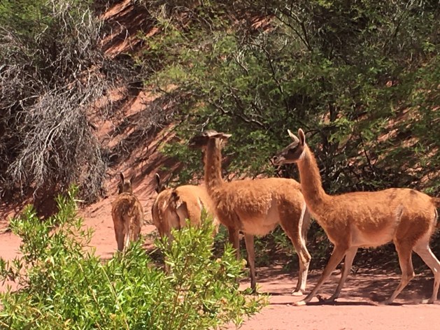
The coolest part was when we came upon a herd of guanaco. Not only was it the first guanaco that I see in the wild, we were right there close to them, in their natural habitat! They let us get about 20 feet away before they finally ran off.
I think the thing that impressed me the most was that we could see where a fault line passed because there was a huge diagonal crack in the walls of the canyon on both sides.
Our guide drew a 24-hour clock in the sand and explained that if the history of the Earth were compared to one day, where the Earth formed at midnight, life appeared at about 3-4am, and the rock formations in the park (that formed 250 million years ago) formed at just one minute and 30 seconds until midnight at the end of the day! (We humans appeared at about 6-10 seconds until the end of the day!)
I stood in awe, with the beautiful, 250 milion-year-old canyon walls towering above me. I felt so tiny and at the same time I felt that I was traveling time, and through that time travel I was connecting to the extensive history of this planet, and somehow that made me both tiny and as big and as old as the planet, all at the same time.
When I got back from the hike that afternoon, it was time for that character-building activity of asking for a lift to Baldecitos, the little town near the entrance to the provincial park Ischicualasto. It shouldn’t seem like a big deal, but for a person raised in the US and raised to be self-sufficient and independent, it is a bit of a psychological challenge. One has to overcome embarrassment, shyness, and fear of rejection, all at once. So I set myself up near the parking lot and asked all the people who drove up where they were headed, and if they were going my direction if they would have room for one more person. About 5 different cars arrived and everyone was very friendly in their rejection, but they were not going my direction.
As one of the excursions returned, I found an older couple that was headed that direction and they were happy to give me a ride. The woman, Ana, was in her 60’s and she is a psychologist in Buenos Aires. They were at the end of their vacation and she had to get back to work after the holidays. She had a private practice and then also worked with the government to do psychological evaluations for people applying for commercial drivers’ licenses. She talked about how she had backpacked through Europe when she was younger and continued to travel as much as possible. They were then kind enough to go a few minutes out of their way to drop me off in Baldecitos, waiting to make sure I found a place to stay.
The woman who owned the hospedaje en Baldecitos was about my age and she lived next door with her little boy of about 12-13 years old. After I got settled in, I saw she was outside spraying the ground with a water hose to control the dust, and I came out and asked her about life in Baldecitos. She was a farmer, with milk and beef cows and also received some extra income from tourists passing through for the park. She was born and raised there in Baldecitos, which has just about 10-15 families living there permanently, with maybe up to 25-20 houses total! (Definitely the smallest town I’ve been in so far.)
A few months prior, they had constructed a cell tower in the town that was also supposed to also bring wi-fi for the community, but it was really spotty, with some of my whatsapp messages delaying a few hours to send.
I feel at home anywhere if I can do yoga with the sunset.
There was a “comedor” (small, simple, family-style restaurant) near my hospedaje where I went to see if I could get something to eat. While there, an older French couple came in also asking about dinner and about logistics for going to the park the next day. The man and older woman in the comedor told us they would serve dinner at 9pm, and that the park opened at 8am and was about 12km down the road.***
This park – Ischigualasto – is the park that you visit by driving through, caravan style, with a guide, stopping along the way to see certain parts. (I had read on blogs that many people without their own transportation look for other people to give them a lift through the park.) The couple seemed really nice and friendly, so I took that opportunity to ask if they had room for one more person, and they assented and said we could chat over dinner.
Over dinner I learned that they had rented a car and were driving down La Ruta 40, with destination Bariloche, but looking for cute little towns and beautiful, hidden gems along the way, just like me (except with a car). They already have grown kids, but they also have this beautiful child-like energy, getting really excited about the places they’ve seen and what there is to see ahead. My kind of people. We hit it off immediately and agreed to meet at 8am the next morning to go explore the Parque Ischigualasto together.
Footnotes:
* Dario (the park guide whose house I had stayed at in Pagancillo the night before) had assured me that many people go between the two parks and that I wouldn’t have a problem finding a ride from Talampaya to Ischigualasto. Since that was consistent with the blogs I’d read on the internet, I felt good about the plan.
**I like to know all the options before I make a choice, and here it took me about an hour to understand how it all works (and that’s after having done research online!) It turns out that this is only one of two different park entrances for the National Park Talampaya. At this entrance, there are two companies – one that offers excursions in jeep that leave on a set schedule every few hours, and another that offers hiking or biking excursions. It is all very confusing because the company that offers jeep excursions is also in charge of selling the Park Entrance fee, which makes it seem like their excursions are the only options. But if you ask around, you find that there’s a small office around the corner that offers hikes and bike rides if enough people are interested in forming a group. As a third option for exploring the park, there is another park entrance about 10km down the road, where a different company offers an excursion in jeep to see another part of the park called “Cañon Arco Iris” (Rainbow Canyon) and “La Ciudad Perdida” (Lost City). I also heard that there is another company forming that will do excursions to another part of the park next year.
***I chatted for a while with the couple in the comedor in Baldecitos asking them about life in Baledcitos. They presented another point of view about the park. They said that while they weren’t completely opposed to the park and tourism from the park did bring some income, they were kind of frustrated that it put restrictions on their ability to raise animals because it was a protected area (and to prevent accidents with the passing cars). They mentioned that would have liked to maintain the practices of their ancestors in the raising of guanaco and cattle in the wide open spaces. They also said that this provincially-managed park doesn’t provide the same job opportunities for people in the community of Baldecitos, like the nearby national park Talampaya which provides jobs for many people of the nearby town Pagancillo. They did mention that a consultation process was used to create the park, but they felt that their opinion was not considered. (The complexity of the situation was not lost on me, since I am reading about Latin American history during my travels. For example, I confirmed that they were specifically referring to their European ancestors who have inhabited those lands for hundreds of years. If you keep going back in time, you come to a point in time where their ancestors usurped the lands of the indigenous people living there. And maybe those indigenous people usurped the lands from someone before them.)
The Atacama desert in northern Chile is known for the best stargazing in the world – and that’s why I HAD to come here. Ironically, I came during the two weeks of the year when it was cloudy and I didn’t get to do proper stargazing (other than a few minutes before the sunrise one morning.)
But, the sunsets!!! Even if I didn’t get to see the other suns of the universe, I got to see OUR sun in all its glory!
The dry desert air makes the incredible landscapes look exceptionally majestic and brilliant, and with a setting sun sending gold in all directions and casting deep blue shadows while tinting the clouds in pink, one will stop whatever she or he’s doing and run to catch the sunset every evening.
All the sunsets were awesome, but the most incredible was definitely in Laguna Tebinquinche*, where the sun set over the white, salt-covered lake and a rainbow emerged in the dark blue rainclouds opposite the sun.
Like many lakes here, the water appears to be covered in a layer of ice but is actually encrusted with a layer of white salt. The lakeshore is filled with “living rocks,” which are salty rocks made up of minerals and microorganisms that can survive some of the harshest environments on the planet. These microorganisms are some of the first living things that came into existence on Earth!
Contemplating the first life on earth, a flamingo flies across the sunset. And with friends made along the journey, we marvel at the beauty of life, the richness of the moment. We all just met each other, and yet we’re all family, born from Mother Earth, who is amazing us with her beauty.
But I digress. Being immersed in this vast desert, looking out across immense spaces and also out into the vast sky, makes one reflect on the grandness of the Earth, the universe, and the beauty of life.
While access to sensitive spots is limited to protect them, there was one salt lake that people can swim in. If you have never swam in a salt lake before, it’s definitely worth adding to the bucket list. Because salt water is more dense than fresh water, the saltier the water the more we float. I noticed the difference swimming in the Pacific Ocean in Lima, but it still didn’t compare to the unique sensation of floating in the salt lake in Atacama!
Look Ma! No hands!
When a large moist area of salty land has dried up, a salt flat (“salar”) is left behind. I saw many salt flats, with the the Salar de Atacama being the 3rd largest salt flat in the world (after those in Uyuni and Argentina). It is so large it can be seen from space.
I was lucky enough to see a few other marvels of the desert during my stay in Atacama, the most grandiose being the National Reserve of the Flamingos (Reserva Nacional de los Flamencos). At 4,200 meters (13,800 ft) above sea level, we saw two beautiful mountain lakes that used to be one great lake until seismic activity of the Nazca and South American tectonic plates created some hills that divided the lake in two.
Another breath-taking desert lake is the laguna aguas calientes. Here, the diversity of the landscapes was overwhelming. There were huge dune-like mountains of black lava rock, a lake of hot water fed by an aquifer that sits on top of a volcanic magma layer, and red hills rich in iron minerals. All accented by the pink flamingos looking for food in the lake below.
Finally, the bike ride through the Valle de la Luna was a challenging adventure through the desert heat, where we met friends along the way, saw incredible rock formations, and watched rain develop across the flat desert plains – the same rain that cooled us off a few hours later.
One final fun fact. The Atacama desert is located on the tropic of capricorn. I’m pretty sure I learned about the tropic of Capricorn at some point in my life, but I didn’t really remember what it was. The tropic lines are the points where the sun shines directly overhead, due to the tilt in the Earth. The regions of land between the two tropic lines are considered “tropical” areas since they receive the most direct sun, typically creating warmer year-round climates than the rest of the globe.
Our guide explains the tropic lines with a drawing in the desert sand. The sign marks where the tropic of capricorn passes, which also happens to be a part of the Inca Trail.
Famous Footnotes
Unless you rent (or have) a car to go see the sites (which would be a great way to explore Atacama), the way to see things is through the tours offered by the various tour companies in San Pedro de Atacama. The tours I took were:
-Tour 1: Laguna Cejar, Laguna Piedra (the salt lake where you can swim and float), Ojos del Salar, and Laguna Tebinquinche (the salt lake with the amazing sunset).*If you take the tour of Laguna Cejar in the afternoon, it usually ends at Laguna Tebinquinche so you can see the incredible sunset here.
-Tour 2: Reserva Nacional de los Flamencos (Laguna Miscanti and Laguna Miñiques), Laguna Talar, and Salar and Laguna Aguas Calientes with overlook to Piedras Rojas
-Observatory ALMA tour (free but you have to get to the meeting point early to get on the list, as I described in my blog post.)
-I rented a bike and rode through “Valle de la Luna” all day (about 6 hours), and another afternoon I rode through “Valle de Marte” and watched the sunset from an overlook point nearby.
**I didn’t get to do a stargazing tour because of weather, but would definitely recommend one!
**I didn’t get to do the geyser tour because rain had washed out the road, but would also recommend that!
The Atacama desert is the driest and highest in the world, and that’s one of the main reasons that we built “ALMA,”* the largest radio telescope in the world here! I say “we” because it was an international collaboration – an example of us humans working together to better understand the universe in which we live.
“The purpose of ALMA is to study star formation, molecular clouds and the early Universe, closing in on its main objective: discovering our cosmic origins.”
To most of us, a telescope is an apparatus of lenses pointed at the sky to see stars, (or far away visible light in the sky). But the ALMA telescope is not one, but 66 antenas pointed at the sky! Just like we have 2 eyes that give us a single image of the world, the telescope has 66 eyes to give us a single image – it’s like a mom that has eyes in the back of its head. Or like a fisheye camera.
The other unique thing about the ALMA telescope is that it isn’t viewing light in space like an optical telescope, it’s looking at the dark and cold part of space, capturing radio waves* emitted by stars and planets.
One of the antenas undergoing maintenance
That doesn’t mean that stars and planets are broadcasting songs. Radio waves are emitted by the cold and cool matter in the universe that doesn’t give off light and so can’t be seen with our eyes (or with optical telescopes). But the ALMA telescope can receive these signals and tell us about that matter out there in space.
For example, the ALMA telescope was able to detect sugar molecules around a young sun, indicating a good possibility for a life-supporting planet to develop in that solar system.**
In some cases, scientists can combine the information from an optical telescope and ALMA (and x-ray and infrared telescopes)* to give a fuller picture of a solar system or galaxy, and to “see” what’s happening in the dark spots of the sky.
Also, since it’s not optic, ALMA can point at the sun and study the sun’s atmosphere without burning.
For me, one of the most interesting abilities it has is to study the early universe – it has found evidence of the earliest known solar system – suns that formed just 250 million years after the Big Bang. (Sounds like a long time, but it’s only 2% of the universe’s current age, which is about 13.8 billion years.)
I know, this is a lot of high tech modern science stuff. But according to our guide, the basic principle behind the antena design is actually something that was used hundreds of years ago by the pre-Incan culture, the Tihuanacu.
Just outside of La Paz, you can visit an archeological site of the Tijuanacu. Then you can head a thousand miles south to the ALMA observatory in northern Chile to see the modern day use of this technology studying the origins of the universe!
While the tour to the observatory is free, it takes a bit of luck to get there. To be on the official list you have to reserve online, usually 6 months to a year in advance. If you don’t make the official list, you might be able to get on the online waitlist. But since the list fills up so far in advance, a lot of people on the list end up not making it on the dates they reserved. So you still have a chance to get on the “hope list” the day of the tour. The bus leaves at 9am, but people show up sometimes 2 hours early to wait in line to be on the “hope list”. If there are any empty spaces from people who didn’t show up from online reservations, next priority goes to the wait list and then to the hope list, in order of arrival. It makes it that much more exciting to get chosen from the hope list! It’s like winning the lottery!
Famous Footnotes
*The ALMA – Atacama Large Millimeter/submillimeter Array – captures electromagnetic radiation with wavelengths in the range of milimeter wavelenths in the electromagnetic spectrum.
(There are also other non optical telescopes that exist- infrared and X-ray telescopes that capture information from other non visible light parts of the electromagnetic spectrum.)
Torotoro was an unplanned surprise adventure that I stumbled across in Bolivia and now I can’t imagine my journey without it.
I had never heard of Torotoro until I arrived in La Paz, where two different people recommend it to me within my first day there. My friend Gabriela said I HAD to see because, as a person that likes outdoors adventures, it was a must-see while in Bolivia.
I decided to do the 2-bus journey from La Paz in one day, leaving at 7am and arriving around midnight (due to some bad luck in my layover).*
Heading out of the densely-packed, busy La Paz towards Cochabamba**, the road soon turned into wide open spaces, with a mix of adobe and brick houses, often many kilometers apart. The landscapes were reminiscent of the Peruvian Andes highlands (sierra), from plains to red rock mountains, and then winding through the hills above a valley, with short little bushes dotting the yellow brown hills.
Torotoro is at an altitude of 2,800 meters (9,000 ft) with a rocky mountainous landscape, but also has a very unique look and feel. The colorful and pointy, oddly shaped hills and rock formations may remind an American of the Southwest, especially South Texas, New Mexico, and Arizona, and also parts of the Rocky Mountains. While the temperature is cool, the days were mostly sunny, and it is noticeably 1,000 meters lower than La Paz, giving one a relief from the cold and altitude of La Paz.
In the tiny town of Torotoro, most people wear the typical rural Bolivian dress- women in colorful skirts, and men in pants and a vest. Most people wear brimmed hats (sombreros), though there are different types between the men and women. But there are two unique things I see here that I haven’t seen in other parts of Bolivia (or Peru):
First, a good proportion of people have official work vests, signaling that many people are employed in the tourism industry, working either for the government or a tourism business.
The other, which I absolutely love, is that there are many guys (mostly older men) that wear the typical Andean “chullo” hat with ear flaps, but these chullos have a long pointy top, like an elf hat…and they wear the pointy part standing up! (Sorry, I don’t have photos of the local dress styles.)
Torotoro is such a tiny town, that even though the tourists stay in hotels around the middle of town, integrated with the houses of the locals, tourist activities feel very separate from local activities, and so it has a bit of a tourist town feel.
The locals have a kind of wary-ness towards me, surely from having had many a varying experience with tourists, and it takes a few minutes of conversation for them to relax and feel more comfortable conversing. I tried to chat with a street food vendor who was also serving some locals, and she was really hesitant to talk. Finally, remembering that I was in a Quechua-speaking region, I tried to speak with the little bit of Quechua I had learned in the northern Lake Titicaca island Amantani. “Soma pollo,” (delicious chicken), I told her. “Yosparasunki,” (thank you)! When she realized I was trying to speak Quechua she smiled (half laughing at me) and then taught me to say “Reposa” (bye).
Torotoro is also a national park, and due to the efforts to protect it, they have recently implemented a strict system for visiting the park, where you always have to go with a guide. (You pay 100 Bolivian Pesos for a park entry fee and then you pay separately for each guided tour.)
The system of contracting a guide is interesting because there is a set cost for each guide and you can have up to 6 people in a group with a guide. That means that most people come just before the office opens in the morning and afternoon to look for other people that want to do the same tour so they can form a group of six to split the cost. Sometimes it works out beautifully and sometimes no one shows up to do the tour you want to do. (But for the two most popular tours, even in low season, there were always people in the early morning looking to form a group. The afternoons had fewer people, though I did get lucky my first day and found a couple late in the afternoon to go see dinosaur tracks and the canyon.)
That’s right…dinosaur tracks! Who knew that in the middle of Bolivia, there are dinosaur tracks!???!?
Many businesses use the dinosaur tracks for their marketing strategy
The area used to be swampy area and over the millennia it dried up and turned to rock, preserving tracks of those massive herbivores and vicious carnivores that roamed the area thousands of years ago.
All in one tour (“El Vergal”), you pass dinosaur tracks and walk along an historic river with amazing geologic formations, leading to the majestic Chiflón canyon.
Just when we were about to leave the rim to begin our descent into the canyon, we caught sight of a graceful condor soaring above the canyon…and then another…and then another. They had emerged just in time to paint the already amazing landscape with their graceful flight paths.
We then climbed down into the canyon, passing a lemon-mint smell of the bodje tree, and later transversing the boulder-filled base for about a kilometer until we arrived at some beautiful waterfall cascades with green-blue pools below.
What a refreshing swim in that beautiful canyon pool!
The next day I successfully formed a group of 6 with my two French neighbors and a group of 3 other French tourists wanting to do a full day tour of the “Ciudad de Itas” and the Umajalanta Caverns.
We first took a 4×4 out to the grand rock formations of the City of Itas, and on the 40-minute drive climbing into the mountains, there were four different languages buzzing about in the vehicle – the guides speaking Quechua in the front, the three tourists in the back speaking French, my French neighbors and I speaking in Spanish in the middle, and the tourists in the back speaking to me in English.
The “Ciudad de Itas” was a hike through incredible rock formations and mountains.
Among many cool highlights were an almost completely dark cave-like space with just a tiny slot of light filtering through from above called “cueva del diablo”, and ancient drawings of llamas and the sun and earth goddess/god preserved in the rock in some cave-like spaces.
Do you see the llama?
We were also led through a maze of rock to a secret hiding place that was a kind of hidden canyon between rocks where the natives would hide stolen cattle during the 18th and 19th centuries, before the land reform times. This was when the Spanish had taken over large swaths of land, and a wealthy, well-connected Spanish “patron” would run an agricultural businesses on “haciendas” (large farms), often practically enslaving the locals while making profits exporting products across the country or abroad. (Again I was grateful for having read Isabel Allende’s “House of Spirits” to have a sense of the history around this time period.)
Another point of interest amidst the rocks was a large opening in a cave-live space in the rocks called the “cathedral” where the locals during Incan times held a gathering to celebrate the gods and goddesses of the earth (Pachamama) and the sun (Tatainti). They would have a type of pot-luck called “A’tapi”, and they would give an offering to Pachamama called “Tcha’lla”.
We also saw photo-luminescent bacteria that glows this green color from one angle but up close it just looks like brown slime on the rocks.
After having climbed to the highest part of the Torotoro area, we then descended below the surface of the earth, to explore the Umajalanta Caverns. While not the most beautiful cave I’ve ever seen, it was definitely the most fun!
Hiking, climbing, repelling, crawling, and scootching through this cave was a fun adventure (and led by an experienced guide and plenty of ropes, it was not as hard or scary as it sounds.) Unfortunately, many of the beautiful formations had been damaged in the decades before it became a protected part of the national park, (due mostly to people not knowing that touching the formations would damage them but also due to some vandalism).
This image is on the 10-boliviano bill
However, there were also signs of hope where the stalagmites and stalactites had started growing again since the cave has been protected for two decades now (since 1989).
I was so happy to have found this little gem in the middle of Bolivia, to explore such a beautiful place, and to support the protection of some natural areas.***
Famous Footnotes
*While I arrived smoothly from La Paz to Cochabamba (other than a hot bus), I had bad luck catching a ride to Torotoro. The buses go “colectivo” style which means they wait until enough passengers come to fill them and then they leave. I waited 3 hours and then it was getting dark and no more passengers were coming so the company passed me off to another company that was supposedly leaving soon but still didn’t actually leave for another hour. I arrived at midnight in Torotoro and needed the next morning to recover from travels.
** Many people told me to “be careful” in Cochabamba. Luckily I had nothing but good experiences with the people there. When I asked at the terminal how to get to the vans for Torotoro, the woman didn’t know so asked a coworker who not only told me which car to take, he flagged down the car and ran the half block to where it stopped to explain to the driver where I was going and to ask him to let me know when we arrived!
***While I would definitely call this an “eco-tourism” experience, the jury is still out on whether it counts as “community-based tourism”. While on the surface it seems to bring some income to many locals, there were rumors that the government actually gets most of the proceeds and that there was a wealthy and foreign family somehow making most of the profits. I wasn’t there long enough to find out to what extent these were true, but even if the government was making profit, they were also employing quite a few people (remember all the vests?)
Side note: There were a few other short tours that I didn’t make it to (like a huge fossilized turtle), so while you can see the biggest attractions in 2 days, it is definitely a place one could stay 3-4 days, especially just to relax in a calm and quiet little village in a beautiful place with a great climate, (though there aren’t tourist attractions outside of the guided tours).
Since I wasn’t able to hike to the Yungas (the lower altitude, subtropical side of the Bolivian Andes) from the mountains, I decided to bike there. In bicycle you can really see the scenery, feel the change in climate, and really experience each moment along the way with all your senses. Sometimes you can even see the change in wildlife along the way.
Since I didn’t know where and how to rent a bike, the easiest and quickest way was to go along with one of the touristy tours that rent you the bike, gear, guide, support van, and transportation to a starting point and back and that advertise the route as Death Road or “the world’s most dangerous road”. Actually called “North Yungus Road” or “Coroico Road”, the route is a windy, steep downhill dirt road that used to be the primary route to Coroico, before they built a new paved route that is supposed to be a little less windy and steep and therefore has fewer incidences of cars going too fast and finding themselves flying off the cliff. (An estimated 300 travelers were killed annually when this was the primary route to Coroico).
As a mountain bike route, it’s not too dangerous since it was designed for cars and so is actually fairly wide. That said, it would be dangerous for someone that isn’t used to biking and tried to ride like a crazy person. I found it to be a challenging but not too unlike many rides I did regularly in Oxapampa. Going with the tour had its pros and cons*, but overall it was awesome, and definitely a great way to get to the lower jungle town of Coroico where I wanted to go.
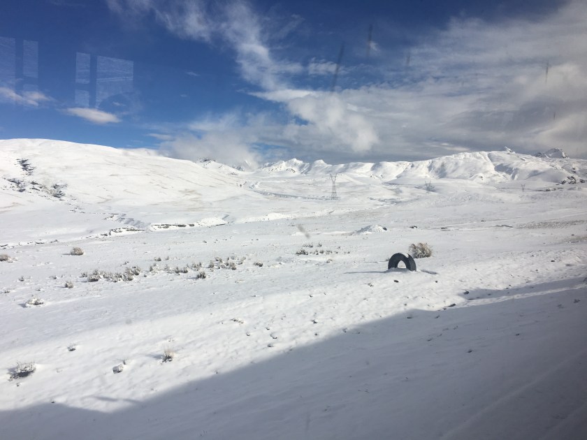
To get to Coroico from La Paz, you first have to pass over the mountains, so the van drove us a few hours to the starting point in the mountains at 4,700 meters (15,400 ft) above sea level. We would then ride down to 1,100 meters (3,600 ft) above sealevel. It had snowed the night before which complicated our arrival to the starting point but made for a beautiful, of very cold, starting point.
From white mountains, freezing fingers, and multiple layers, we quickly descended to green hills, greeted by the smell of the moisture and vegetation characteristic of the tropical jungle, (and making me nostalgic for Oxapampa). The views of the hills and valleys, and the river cutting through the valley below (way below), were indescribable. (Sorry, don’t have photos.)
Arriving in the valley, one perk of going with the tour is that we had access to a beautiful little resort with an all-you-can-eat buffet, rustic showers, and even a pool.
The two guides were also cool. One guy was a medical student and was explaining that to be a doctor in Bolivia, one has to study for 5 years, then do a one year internship in a hospital where they don’t pay you anything, and then ANOTHER one-year unpaid “rural internship” where you work in a rural site in “provincia”. (Ok, so this one’s not completely unpaid – the interns receive 15 pesos bolivianos ($2) per day.) Just when I thought the US doctor training program was not ideal…
As the van then continued back to La Paz, I caught a car for a 15-minute ride to the little city of Coroico. I arrived just as it started to rain, so I spent the evening resting and cooking myself a meal in the hostel.
Coroico is a small town with the streets buzzing with activity. There are many little stores (tiendas) and restaurants on every street, vendors selling vegetables and fruits in the street during the mornings, and kids running to and from school in the mornings and afternoons. At night, kiosks open up selling fried chicken and fries – which seems to be the Bolivian evening meal choice, second only to Silpancho – rice, potatoes, carrots, beets, tomato, chicken fried steak, with a fried egg on top. (To avoid an early heart attack and to be able to sleep at night, I cooked a stir fry of vegetables and quinoa for my evening meals, with the bonus of spending less than I would have eating out.)
The town was small enough that I quickly felt at home there. People weren’t immediately warm – everyone was busy living their lives and didn’t even notice a random tourist walking the streets, which I kind of liked. Often they didn’t even hear me greet them, (or were so surprised at a tourist greeting them that they didn’t know what to do.) But when I did get a chance to chat with someone (like the woman who sold me juice or the guy managing the hotel), they were super nice, chill, and helpful.
I read that there were three main sights to see in Coroico – the stations of the cross that lead up to a chapel on a hill with a nice view, and then from the chapel there are two 4-ish-hour roundtrip hikes – one to a hill that overlooks the city and the other to three waterfalls.
I packed my bag with swim gear, asked a couple of people how to get to the waterfalls, and then headed off, running, following a trail that wound around the side of a few massive hills. I was pretty disappointed when I arrived about an hour later and only saw a tiny fall with nowhere to swim, and it seemed that it was just a water capture point for the city. Maybe an appropriate thing to find, since I’m a water engineer, but disappointing.
So I ran back to the chapel, arrived at 4pm and decided to try to climb the overlook hill. The hill started as an open, desert-like hill covered with rocks, dry grasses, and only short bushes.
After about 30 minutes I was surprised to suddenly enter what was like jungle – thick trees blocking the sky and the smell of moist soil and vegetation. After a few minutes, I emerged again from the jungle and the trail opened up again to less dense vegetation and dried grass, only to turn into jungle again a few minutes later.
When the vegetation cleared, there were incredible views of the valley and the towns down below, including the little city of Coroico, which appeared much bigger from above than it seemed being in the city.
Towards the top, the hill turned into pure jungle, and I was sweating even though it was getting chilly as the sun started going down. Jogging uphill, I was thankful for the extra lung power I had gained being at altitude for almost two weeks. I didn’t want to get caught in the night in the jungle, so I decided I would turn around at 5:45 even if I didn’t make it to the top. I kept thinking I was near the top but would find that there was still more climb. I was pretty sure I wasn’t going to make it to the top, and then magically, at exactly 5:45 I arrived to the clearing at the top of the hill! Win!
The next day, I was just about to leave Coroico and I learned that the waterfall I went to was definitely not the waterfall that everyone goes to. I decided that I couldn’t leave without going to the waterfalls, so I started walking (this time the right direction), and then found a car to take me the rest of the way. When I got to the waterfall, I decided it had definitely been worth it! There was not much water in the cascade because I arrived just at the end of dry season, but there was a beautiful pool under the falls calling my name, (and two guys swimming there also calling me to join them).
The guys were from La Paz and had come out for the weekend just to enjoy this specific spot. With little hesitation, I was soon splashing around in the pool beneath the waterfall with them. Within a few minutes, another guy from La Paz showed up – he was showing around a friend from Quito, Ecuador who had come to visit Bolivia for a few weeks. We all became friends for the afternoon and I even ended up catching a bus back with the Ecuadorian woman and her Paceño friend.
Turns out that Coroico, and specifically the falls, are a nice little weekend escape for Paceños. With its warm climate and green hills, it’s a nice escape from the cold, altitude, and busy, tree-less city. I’m so glad I went off the beaten path to find this little gem (and to make a few more friends along the way)!
Ignore the jacket…it was actually warm in Coroico, but after swimming in the cold falls I needed to warm up
Famous Footnotes/Bonus Content
* The pros of going with the mountain bike tour were the sag wagon and the food included, but the cons were the cost (it was outside of my low budget but I gifted myself that day), and that it was so touristy that the group had to stop every few minutes so the guides could take photos of each person to later send us.
**I somehow lost my water bottle in the car that I took to the waterfalls, and I was pretty bummed, but then the driver showed up at the falls within 5 minutes, having noticed that I left it. Good, kind people in Coroico!
***Often when I mentioned that I went to Coroico, Bolivians asked me if I saw any black people. Actually, I didn’t. But Coroico is apparently part of the area where many African slaves were brought to work on haciendas and so many Afro-Bolivians live in the surrounding areas.
After a ridiculously cold and uncomfortable night (the first night camping is always the hardest), I was happy for day break so we could start hiking to go find the glacier lake.
If the first day was pure climbing, the second day was pure rock scramble – my favorite way to hike (and I’m not being sarcastic).
Add the fact that there was snow on the ground, and I was in heaven! Actually, it was more like hail or frozen rain because it was tiny little white ice balls, like I’d never seen before. But whatever it was, it was white and beautiful and made that wonderful crunching sound beneath our feet.
We climbed up and down (mostly up), over about 4 ridges on the side of a mountain, crossing a few landslides, literally climbing on the face of the mountain much of the time, and it was exhilarating. I fell once but I caught myself and didn’t die! Win!
We didn’t talk much because we needed all the air for breathing, as the air was getting thinner and thinner as we gained altitude. We both were chewing coca leaf to keep from getting altitude sickness.
As we crossed over the side of the great peak Illampu, the view suddenly opened up to reveal the beautiful glacier lake.
The grand Illampu rises over the left of the lake, while Ancouma rose over the right side (though Ancouma was hiding in clouds).
At the far end of the lake, the snowy side of a mountain seemed to be constantly feeding the lake with a glacier and avalanches.
The lake created an optical illusion such that it was actually much larger than it seemed; after 20 minutes of hiking I still hadn’t arrived to the far side where the snow and ice was falling into the lake, so I headed back since my guide was a little anxious to get back.
Every few minutes I would hear the distant sound of avalanches, but I could never find them when I looked up into the mountains.
The next day, we headed across the mountain pass to see some ruins, a couple of overlook points, and the Spanish Gold trail. We were walking in the clouds the whole way down, so unfortunately I didn’t get to see some of the amazing views. Despite the fog, I still loved it!
We normally would have hiked about 5-6 hours and camped one more night, with a campfire at a mirador, but with all the fog and my stomach acting up, I convinced Eduardo to to do an 8-hour hike that would bring us all the way back to Sorata in one day. Turns out we would have gotten rained on in the night if we had camped, and I didn’t have the most waterproof tent. Win #2!
The day was long and challenged my glutes again, but I enjoyed it just the same.
We hiked along the Spanish trail or the Gold trail, which is the trail that was used by the Spanish colonial rule to deliver gold from a mine in the mountains down to Sorata, carried by the locals who were used as slaves in the gold mining business. (My first night in Sorata I had stayed in a hostel that seemed like a really old house, and I later learned that it used to be the place where the slaves (indigenous people) delivered the gold to the Spanish.)
Walking along the Gold Trail, glutes screaming, sore shoulders, I thought about how this would be torture if someone was forcing me to do it, (especially for their own profit and not for me). But since I had chosen to do it, and I could go at my own pace and enjoy the scenery, and I was not doing it every day, it was something I actually paid to do. Privilege.
Eduardo continued to tell me the history of Sorata while walking this trail. He explained how the Spanish enslaved the locals not only for mining but they also set up the big haciendas, where the Spanish “patron” treated the locals like slaves to work the land and produce crops as efficiently as possible while the patron then got rich from selling the products, sometimes on the international markets that he had access to. The conversation invoked memories or reading Isabel Allende’s “House of Spirits”.
Eduardo went on to say that there came a time when the young rebelled and received a few more rights so they weren’t so much like slaves, but it wasn’t until later with the big land reform policies that the patrons left and locals could own their own land and reap the benefits from it.
Since then, he said, the community has organized itself so that each person owns their land where they live, and then the land in the hills above the community is common land so that anyone in the community can farm it. They meet once a month to resolve community issues and they rotate the leader of the community every year. Anyone with land in the community is registered on the “roster” and therefore has rights to farm the community land and also has the responsibility to serve their rotation as leader of the community for one year.
As I arrived back to Sorata, I could not believe that we had walked that entire distance. I had left behind the busy world of getting everywhere fast, and I had reunited with the age-old tradition of walking. I was just stunned at how two legs, two feet, could take me across massive hills and high up into the mountains, across distances and through terrain that seemed impossible, or difficult at best, to cross. It was a reminder how much I appreciate my feet and also the power of the human spirit and body.
Bonus Content: What do the kids do in the evenings in Sorata? As I made my way back to my hostel, all along the way, kids were playing with the same top-like toy in the streets, so I stopped at one group of kids and asked an older kid to show me what they were playing. He was super shy at first but I finally got him to show me on camera, and he let me try a few times too.
(Unfortunately I am having technical difficulties uploading videos here, but you can find the video on Facebook).
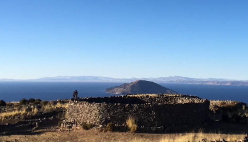
As I was walking on Isla de la Luna in Lake Titicaca, I caught my breath as I looked across the lake and saw grand white peaks rising out of the horizon.
If you know me, you know that I have a love affair with mountains, and especially those majestic white, snow-covered mountains (“nevadas”). The mountains seductively said to me “You’ve hiked in the Peruvian Andes, are you up for the Bolivian Andes?”
So after leaving Copacabana, instead of taking the usual route to La Paz, I got off the bus early and caught a few cars to get to Sorata, a small mining town of about 4,000 people about 3 hours from La Paz and a starting and ending point for a few different treks through the Bolivian Andes.
I had heard that Sorata was a mining town, but I was still blown away when I saw a sign in a store off the main plaza that said “I buy gold. I sell mercury.”
I had laughed when my uncle heard I was going to Bolivia and told me to take a metal detector and to look for gold…but turns out he knew what he was talking about!
Other than the sign about gold, the town reminded me of any small mountain town in Peru. With a nice plaza in the center,* the main church and municipality building off the plaza, and shops filling the streets around the plaza. And because the town is on the side of a mountain, the streets off of one side of the plaza were an incredibly steep climb up, while the streets off the other side were a steep descent.
I arrived on Sunday when they had their “feria”, or market day, when people from the surrounding areas bring their products to sell – potatoes, acacha (a long, skinny, knobby potato), habas (a big, protein-filled bean), snap peas, herbs, carrots, green beans. Similar to Peru, they would bring their big colorful “manta”, spread it out on the ground and neatly arrange their products to sell. Common to all markets I’ve ever seen in Peru and Bolivia, there were many different vendors, all selling the same things.
I had sought out a local, Sorata-based guide association and “Eduardo”, a local guide met me in the plaza when I arrived and introduced me to his wife and daughter who were enjoying a Sunday walking in the plaza.
I was fascinated with the option of doing an 11-day trek through the Andes that included climbing a snow-capped peak and ending in the “Yungus” (the lower altitude, warm climate of the jungle on the other side (east) of the Andes, but I wasn’t able to pull together a group to do it with. Since it would be just me and the guide, I decided to do a 3-4-day trek to a glacier lake between two snow-capped peaks, “Illampu” (Aymará for “fat of the llama”) and “Ancouma” (Aymará for “white snow”).
That evening we bought food and supplies and the next morning we started off from the town’s center, which is located low in the hills at 2,600 meters above sea level (8,500 ft). Eduardo pointed to the mountains in the far distance. I could not believe that we were going to arrive all the way there walking, (and with 15-20 kilos in my backpack) within a day. But he confirmed that we would do it. So I just put one foot in front of the other and waited to see what would happen.
It happened to be “Día del peatón”, or “Pedestrian Day”, the one day of the year in Bolivia where cars weren’t permitted to drive, which was lucky for us because our hike started along a dirt road, and when cars (illegally driving that day) did pass by, they kicked up a ton of dust which didn’t help breathing through the uphill climb.
Finally we got off the road and the smell of eucalyptus (one of my favorite smells of all time) filled the air and I realized we were walking through a eucalyptus forest.
Fun fact: Eucalyptus is an invasive from Australia that sucks the water and nutrients out of the soil…. But it produces wood quickly so people keep it around.
Later, the climb got steeper and the smell changed to muña. Another smell that I love, and this time there’s no worry about it being an invasive species. Muña is native here, it’s used in tea and is helpful preventing and alleviating the effects of altitude.
The first day was pure steep, uphill climb, like climbing stairs for 6 hours, without any flat parts to rest, so we took breaks every 30 minutes or so. It reminded me of the constant climb up Volcán Misti in Arequipa, including the burning glutes with every step (yep, for 6 hours).
My guide is a really nice guy who’s been a guide since 1993. He started as the front desk staff at a hostel that did tours. Trekking tourism started to boom in Sorata and one day they needed a guide so he went out with a group, and he loved it, and they loved him. He knew his way through the mountains because as a kid he used to take sheep out to graze through the mountains to make cash and as a curious spirit, he would go exploring new parts every time.
As more and more tourists flooded to Sorata to do treks, he formed the Association of Guides in Sorata, which ultimately had 30 guides and 20 arrieros (donkey handlers), all professionally trained. He loved meeting people from all over the world, learning from them, and exploring with them. He especially loved learning about new foods and ways to cook in the mountains. He picked up English and even a little French and Hebrew.
Everything was great until 2003. That’s when the Bolivian gas conflict exploded, with the country divided between plans to build a gas pipeline to export gas to the US and Mexico and a growing movement calling for Bolivia to build a local processing plant to get more value from their product and to meet internal gas needs before exporting. Between internal protests and international relationship problems, the booming tourism suddenly halted.
Since then, tourism in Sorata is starting to pick back up, but now most of the tours are dominated by agencies out of La Paz that charge double or more and often contract local guides anyway. When Eduardo goes out with big groups, his wife sometimes comes along to help, and his sons had come along a few times too, (but they didn’t enjoy it as much).
We ate lunch at 3,800 meters (12,500 ft), (the same altura as lago Titicaca), and then after about 3 more hours of climbing, we arrived at our campsite at at 4,200 meters (13,800 ft), a mountain lake “Lago Chillata”.
“Chillata” is Aymará for “the sacred lake where people go to pray, sobbing for help from the divine”). Or, to the Incas before Catholicism, the lake was called “Kotaato” – Aymará for “the lake in the middle of the rocks”.
Here, the clouds roll in thick around 4pm every afternoon and the fog hangs around until the middle of the night, where it clears up and the temperature drops below freezing.
As the clouds are rolling past, visibility sometimes would clear for just a few seconds, leaving an incredible view of the sun setting on the great white peaks of Illampu and Ancouma. (Many times I ran to a high point to get a photo, and within 10 seconds it was already covered in fog again by the time I got there.)
Tomorrow we’ll be able to leave the heavy stuff at the campsite as we head towards the great peaks to find the glacier lake that is tucked between them.
*Famous Footnote/Bonus content:
While wandering around the plaza the night before the trek, I saw a group of people speaking English in the plaza. I approached them and learned they were a chapter of Engineers Without Borders doing an Eco-bathroom project in a nearby rural town! I find my people all over the world!
La Isla del Sol is the biggest Lake Titicaca island, and it is also the most visited by tourists, due to its convenient location just a 2-hour boat ride from Copacabana, the popular tourist stop between Bolivia and Peru.
It is apparent that the island has developed around tourism – there is an abundance of lodging (hospedajes) and restaurant options, and even signs pointing the way to tourist points of interest like overlook points.
You know international tourists come through a place in Bolivia if you find a pizza restaurant, and there are a ton of pizza restaurants on Isla del Sol.
I was really struck by the beautiful architecture and especially the facades of many of the hospedajes, most of which incorporated rock or pebble to adorn traditional adobe construction.
It is also close enough to the mainland peninsula (with a tiny tree-covered island in between), that it is connected to the electric grid of the mainland, unlike Isla de la Luna, which relies on solar panels.
Isla del Sol has three different communities and is less densely populated than Amantaní, with approximately the same population but spread throughout the 14-square-kilometer island (compared to Amantaní’s 9-square-km). (But both much larger than the tiny 1-square kilometer Isla de la Luna with just one community of 27 families).
Just like the other two islands I visited, the geography is that of a mountain rising out of the sea…er, lake. (It is very easy to forget that I am on a lake and not the sea!)
The point is that everything is uphill from the shore. And even walking around from place to place on the island is like hiking in the mountains – a lot of up and down (which always feels like there’s more up than down) at 3,800 meters of altitude.
The boat I came in arrived at the port Pilko Kaina with Incan ruins to explore.
From there to the rest of the island was a surprisingly long climb up.
I really wondered if I was going the right way and if all this climbing was going to be worth it in the end. But I persevered, meeting some friends and some awesome views along the way.
I eventually wandered upon two other lost tourists and soon we came to a house which turned out to also be a fancy restaurant on the edge of Yumani, the community most frequented in Isla del Sol and full of restaurants and hospedajes.
They stayed to enjoy some gourmet food while I continued along in search of a place to stay the night and a cheaper lunch since I was on a really tight budget, and running low on cash at this point.
The site where I did eat lunch was indescribably beautiful. The view of the lake was breathtaking (literally and figuratively at 4000 meters above sea level)… so blue, and so immense, stretching as far as the eye could see. The only sounds were a few birds and a distant conversation in Aymará, with the light sea, er, lake breeze whispering past my ears. Ultimate peace.
And it was the best meal I’d had since Amantaní – fresh trout from the lake with some fresh veggies.
Later, heading to the lookout point to catch the sunset I met and chatted with a local woman selling souvenirs who appeared slightly younger than me and who had curious and rowdy 2- and 4-year-olds. She had lived in São Paulo, Brazil and so not only spoke Aymará (the local language on the island) and Spanish, but also Portugués from her time in Brazil. She had returned to Bolivia because she said they had been treated like second class citizens, her husband robbed at gunpoint a few times, and other Bolivian migrant friends injured or killed…she said her experience was that there was no justice as the government didn’t really value their lives, safety, and rights as immigrant workers. (USA, can we please not be like that???? Pretty please.)
After doing yoga and watching the sunset with her and her kids, I headed to another overlook point.
There I met a super sweet couple – a Spanish woman and an Argentine who ended up staying two extra nights and exploring the whole island (even the northern part which we had been told could be dangerous because of an inter-community conflict that started two years ago), and they said it was incredibly beautiful!
Unfortunately I was running low on cash and had to return to Copacabana the next morning to change money and continue my journey. So, after a delicious dinner of trout from the lake (yes, again!) I headed to my hospedaje and had my last peaceful, Lake Titicaca island sleep.
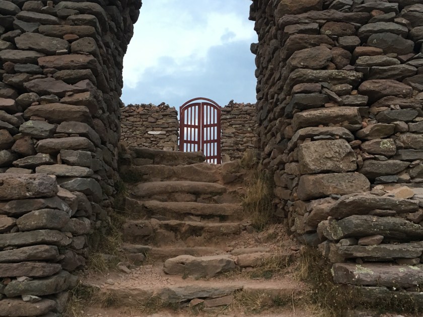
The next morning, after watching the sunrise and eating breakfast, I headed down to the dock, past the Fuente del Inca and saw the grand island entrance to the Yumani community.
I had the pleasure of chatting with a few local women while waiting for my boat. This might have been one of the highlights of my stay here. Using my handy language chart, I practiced my Aymará with them, and we were all highly entertained (even if they were laughing AT me not WITH me at times!) Similar to Isla de la Luna, most people have their farms where they grow the typical sierra (highland) crops- quinoa, wheat, corn, and a variety of potatoes, and animals (mostly sheep), while the income from tourism helps provide something extra.
With a farewell photo, I said “juspara” (thank you) “jakisiñkama” (goodbye)! and boarded the boat for my last ride across the majestic Lake Titicaca.
Sometimes we travel long and hard to arrive at our destination. And then sometimes the journey itself is so beautiful and interesting that it is part of the destination.
Getting to Amantaní is one of the latter. The hour-long motorboat ride through the lake was was both fascinating and relaxing at the same time. A vast expanse like the ocean, but calm, with only minuscule waves, passing islands along the way that I had seen from the shore just a day before…and passing the shore that I had been on just the day before, staring out to where I now was in a boat!
When I arrived at the dock, I was greeted by a smiley and warm, short and round woman who introduced herself as Silveria, the wife of Romulo, with whom I had organized the stay. She led me up a steep sidewalk with many stairs along the way, and after just 5 minutes I was huffing and puffing with my 15 kilos of backpacks and just my second day in the altitude. But luckily, we had already arrived!
Their house is located close to the dock, and my room had big windows with an incredible view of the lake!
Just like in Ccotos, in the shade it’s cold and I need my 2-3 layers, but sitting in the sun for a few minutes I could wear just a long-sleeve or sometimes short sleeve t-shirt, so I sat in the sun while Silveria prepared lunch.
Chatting over a delicious lunch of local varieties of potatoes, an assortment of vegetables, and local bread, I learned that Silveria had run from one side of the island to the other in the morning, first helping her step-mom on her farm, then working on her own farm on the other side of the island, and then running to the dock to meet me. She said it took her about 30-45 minutes to run from each side of the island to the other.
Over lunch, we shared stories, getting along so well that we even began sharing about our childhoods and a summary version of our life stories! After a rough childhood, she was very happy to have a peaceful life with a nice house and a nice husband, living a good life without want. She reminded me of a sweet and hospitable southern woman, someone who had grown up in a machista culture and had a rough childhood but had made a better adult life for herself and lived constantly thankful for what she has now, moving and speaking in a manner that was both self conscious and humble, yet confident in its own way.
In Amantaní, similar to Ccotos and the surrounding areas, people’s first language is Quechua because that is what is spoken in the home. I asked if Quechua was taught in school, and the response I got was, “No, everyone knows Quechua so they don’t need to study it in school.” I was told that typically children speak only Quechua until age 5 when they begin going to school, where they start learning Spanish and school is pure Spanish.
It was interesting to me that, while speaking to Silveria, she was quite self conscious of her Spanish, even commenting that my Spanish was better than hers (though as we talked more and became more comfortable talking, her Spanish flowed more and more fluidly.)
In the late afternoon, Silveria walked me up to the path that led to the highest points on the island-two hills close together, each with a sanctuary to Pachamama* and Pachatata, respectively.
She left me and I continued to climb, slowly, step by step…up to 4,200 meters, my lungs wondering where all the oxygen went, and the temperature dropping rapidly. I was surprised as the land and hills began to give way to water on either side (apparently I had forgotten I was on an island).
My plan was to watch the sunset from there, but the clouds rolled in cutting it short. What I did find as I got closer to the sanctuaries was a ton of tourists! (And a ton of local women selling chullos* and sweaters and crafts and souvenirs all along the paths)! The tourists had all come out from hiding wherever they were staying on the island, and everyone had come to watch the sunset up here.
I got a little confused getting back to the house, and as I asked an older man who was walking with a child, he sent the little girl to walk me to the corner where I needed to turn. I found this simple reaction to be so strange and so kind – but very different from most places where everyone is in a hurry and busy with their own things and also worried about sending kids off alone, even for a few blocks.
That night over dinner, speaking with Romulo, I learned that the island is actually quite organized around the home-stay tourism and they usually partner with tour companies who bring in large groups of tourists at a time. The community is divided into 10 communities, and each community rotates being the host of a group of tourists, with each family in the community offering space in their house and meals to the visitors. Each community also has a community center where they perform traditional dances and have a party with the group of tourists. (I had bypassed this system, contacting Romulo directly, and he said this was a much better deal because he directly receives the payment, and they even have a problem with one tour company that never paid the island for hosting a group.)
I was really impressed by how organized the island of 500 families was. They meet every Sunday, first the whole island, and then they break into meetings just for each community. Romulo explained that it was their only way to get news since there wasn’t a radio station on the island just for news about the island (though they do get regional radio stations from Puno and Juliaca).
They also coordinate which communities plant which crops when, and they rotate, making sure the land has time to rest. Because of the population and limited amount of land, the island is not self-sustainable and the crops produced are not enough to feed everyone so they do have to buy food from the mainland in addition to what they produce. Because of this, the money brought by tourism is crucial for the residents.
The night was so quiet and peaceful and the stars so incredible!! And it was cold. I didn’t dare shower and I slept under about 6 heavy blankets. Before going to bed, they told me if I had to use the restroom to use the “pee bucket” under my bed instead of trying to brave the cold and go to the bathroom. I had heard of these “pee buckets” from other Peace Corps volunteers that lived in the mountains, but I had never seen them for myself. (Turns out it was just a plastic tub.)
The next morning I took a stroll along the shore…
And then we all had a crepe-like “pancake” breakfast, learning about each other’s families.
Later, Silveria walked me to another spot on the island that the tourists often like to visit, the Inca’s chair. To walk there, I noticed that she took time to put on a nice shawl, and she also brought along her knitting…and continued to knit as we walked there! (I was highly impressed.)
Everything on the island is somewhat of a climb…at this point I realized that as an island, it’s really just a big hill or mountain jutting out of the middle of the lake, with the middle of the island being the high points and the shore the low points, so you really have to climb to get anywhere unless you are literally just walking along the water.
I really fell in love with the island, with its stone paths connecting the 10 different communities. I saw the island to be filled with with trees, houses and farm plots. There are no vehicles – everyone walks. (Though I did see one motorcycle in the two days I was there.)
The Inca’s chair was a beautiful spot on the beach and I camped out there until lunch, writing, and then returned after lunch to watch the sunset.
Dinner was delicious and a really great conversation, including Romulo showing me a photo of Silveria and complimenting her to me (with her sitting there in the kitchen) saying what a beautiful wife he had and what a great cook she was. I practiced a few of the Quechua words they had taught me, commenting that the food was delicious and thanking them for it:
(My Quechua spelling is surely not correct, but that’s how I remembered to pronounce it.)
Muña- the minty-smelling herb that helps with the altitude and stomach problems. We had fresh muña tea every meal!
Before daylight broke the next morning, I left the warmth of the 6 heavy blankets and headed out to run/walk up to the highest point of the island, the sanctuaries to Pachamama and Pachatata, to watch the sun rise and start the day with some yoga and meditation at 4,000 meters (13,000 feet).
Starting at 3,800m, and climbing to 4,200m (13,000 feet) was not a walk in the park and I had to stop to breathe a few times and also take off some layers, but in about 45 minutes I reached the sanctuary and did a few sun salutations because, well, for obvious reasons.
While I was meditating I heard what sounded like a fan motor off to my left. Then I suddenly heard it in my my right ear, I opened my eyes and was amazed to see a hummingbird (“luli”) floating just one foot from my face, checking me out and whispering (quite loudly) in my ear, with its thousands-of-beats-per-minute wing-flapping motor. After 3 seconds it flew away, but left me feeling like I had just received a message from Pachamama delivered by a Chaski* in the form of a hummingbird.
After breakfast, I had to say goodbye, and I mentioned that I was sad to be leaving because I really felt at home with them and was so thankful for their hospitality, and as I saw their faces light up with genuine happiness, I was really touched to have met such kind people that opened their homes and lives to me for a couple of days!
When I had arrived, I had greeted them with the handshake, hug and air kiss that I was used to in Peru, but awkwardly found that they were expecting only the handshake. Out of habit I accidentally made that mistake twice! But upon leaving, they each reached out for a hug, and I felt a special connection to this family and this beautiful island in the middle of the highest navigable lake in the world.
Famous Footnotes:
*Pachamama – the Incan word for mother earth, which is revered with a god-like respect and reverence
*Chaskis were the Incan messengers that traveled the Incan roads delivering messages throughout the Incan Empire
*Luli – what Silveria called the hummingbird – maybe the Quechua or a local word for the hummingbird. She said it was a sign of good luck for my journey
*Chullo – the warm hat with ear flaps commonly used in the mountains of Peru and Bolivia. I learned from Romulo that if your ear flaps have dangly balls like mine, you can tie the earflaps back when you are eating so they don’t get in the way!