My favorite part of my job is definitely when I get to be out in the field (“campo”), inspecting or repairing water systems with the operators or the volunteer water committees… and yet I haven’t written much about that, so today I am taking some time to share some of the work we did last week.
An important part of maintaining a rural water system is cleaning and disinfecting it regularly so that sediments, microorganisms, and mold don’t build up inside. This can be a little complicated because it requires high concentrations of bleach in a confined space, that later have to be disposed of in a safe site (not a river or stream). So, you can see why training water system operators to properly clean the water system is an important job.
You may recall that we had a hands-on workshop with the system operators back in April, where we went to a water system and actually practiced the disinfection process. But since every system is a little different, and it takes a few times to change old habits, we are now doing one-on-one trainings with five different communities. Since we are working with a group of university students studying environmental engineering, we invited them to come learn and help with one of the systems.
It is quite a coordination process working with volunteer water committees because we have work within their schedules. That means we wait for the water committee to schedule their next meeting, we attend the meeting, we find out when they plan to do their next cleaning, and we ask if we can come oversee the process and help out. For me, that means a 30-minute bike ride (each way) through the beautiful green hills of Oxapampa to arrive at the community each time we need to coordinate, attend meetings, or and participate in activities. (Poor me!)
All the coordination paid off this week, and we had a great hands-on training, resulting in an improved process for cleaning and disinfection that will make it quicker for the operator and will protect the nearby river.
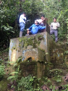
Another day during the week, 30 minutes on bicycle in the opposite direction, we did a water system inspection with the group of university students. After hiking up through one of the beautiful verdant hills for more than an hour, we arrived at the spring box where the water system collects water from a spring. We took measurements and discussed what was working well and what could be improved, and then descended, doing the same for each component of the water system.
Later in the week, we returned to the same system to train the university students in monitoring chlorine levels. We explained the key monitoring points in the distribution system, and we then went to each point to take measurements, (me in bicycle and them on their motorcycle.) Their homework was then to monitor the chlorine for a week, create a registry for the results, and to then train the operator to use the registry.
That same day, the operator had identified a leak in the system, so we took the opportunity to help him fix the leak, learn his procedure, and point out a few additional best practices for the future. The operators tend to be elected by the community, and often don’t have any water-system-specific training, but because they have often built their houses or worked on similar projects, they have a general idea and incredible ingenuity and can complete the basic functions, even if they aren’t aware of the best practices.
The field work is really my favorite part of the job, so I’m really happy to be in the field-work phase of our project – that means more time working side-by-side with water committees and operators, so they can be more effective at ensuring their communities have clean water.
I have had the great fortune to have found some incredible friends in my site, and not one day passes that I am not thankful for them! With two of my best friends, we had been talking about escaping Oxapampa and traveling together…and this year we finally made it a reality! We left the high jungle, or “ceja de selva” (eybrow of the jungle) of Oxapampa and we headed north to the other side of the country, to the “ceja de selva” of Chachapoyas, in the department of Amazonas.
The arrow points to Chachapoyas, and the red dot is Oxapampa.
Chachapoyas hosts tons of international tourists who come to see Kuelap (sometimes referred to as the Machu Picchu of the north), the grand waterfall Gocta, and tons of other ruins, artefacts, and beautiful natural sites, all a day trip from the city of Chachapoyas, where there are plenty of accommodations.
We were lucky to find a special and got a cheap flight from Lima to Jaen, Cajamarca, and from Jaen, we took a 4-hour bus ride (MovilTours) to Chachapoyas. (Some people fly into Tarapoto and get a car to Chachapoyas, which is about 8 hours in car. Or, there is always the option to take a bus from Lima to Chachapoyas, which is about 20 hours, and worth paying for the more expensive seats on a luxury bus like Cruz del Sur.)
In Chachapoyas, we stayed in Backpackers Hostel, and each day we did a day trip from Chachapoyas. Our itinerary included:
Day 1: Rodriguez de Mendoza – Leo’s cave (Caverna de Leo) and hot sulfur springs (Aguas Termales)
Day 2: Kuelap
Day 3: Gocta (waterfall)
Day 4: Karajía
We wish we had had about 2-3 more days to be able to visit Leymebamba, which is 3 hours from Chacha and home to the Laguna de Los Condores and a museum with bones, mummies, and artefacts found around the laguna and in the area.
Day 1 Rodriguez de Mendoza. After eating breakfast in a small restaurant (and laughing until we cried when the waitress took Carolina (who is Argentinian) for a non-Spanish speaking tourist and spoke really loudly and slowly and simply to her in Spanish), we headed to the terminal, where we caught a car to go to Rodriguez de Mendoza (S/20). It was a beautiful 2-hour drive through the majestic, green, rolling hills. There were also palm trees, which we were told were brought in by an outside organization to cultivate, but they didn’t really turn into a big venture so they aren’t really maintained, but they remain an interesting feature in the landscape.
In Rodriguez de Mendoza, we took a 20 minute car ride (S/5) to where a man named Leo gives tours of a cave on his property (S/20). (Slightly less sketchy than it sounds, but worth it!) Leo is about in his 60s and he led us up a hill, through his beautiful property, filled with native plants, coffee plants, and fruit trees, to the opening of a cave. He gave us all flashlights and led us down into the cave, which was many stories deep, with different levels and tons of great formations. He claimed it was incredibly extensive and that he could lead a 6-hour hike through the cave and still not see everything, but since we only had one hour, he proceeded to tell us what he thought each formation resembled (Biblical figures, animals, etc.) We were a little disappointed because we would have much preferred to walk around and see more of the cave, but overall, it was a really cool cave (and a great hike to and from the cave), so I’m glad we did it, and I would recommend it.
We then took a car about 15 minutes (S/5) to a site with a natural spring feeding thermal baths (S/3). This was my first time in thermal baths and I was enchanted by the experience. There were two pools of turquoise water, in the middle of nature, surrounded beautiful scenery on all sides. I don’t think I’ve ever swam surrounded by mountains on all sides, a tiny drop in the middle of paradise. The sulfur smell took a while to wash out of our hair, but it was well-worth it. We ate at a restaurant just above the springs, on the same property, and were lucky enough that two different cars gave us rides back to Rodriguez de Mendoza, where we caught a combi (van) back to Chachapoyas (S/15), just in time to be able to arrive before dark.
Day 2. Kuelap – ruins from a fort of the Chachapoyas culture (1100-1400 AD), in the high selva of Amazonas, with a recently-built teleferico (ski-lift type of air transport) over the mountains to arrive at the entrance. (Fun Fact: Machu Picchu is also tucked in a high selva zone, but in Cusco.) We talked to a guide agency in the plaza and secured a day trip to Kuelap, with teleferico, entrance fees and lunch included for S/75. Unfortunately, it was a drizzly, grey day, so we didn’t get quite the spectacular photos that one normally gets at Kuelap, but even through the mist and clouds, it was spectacular…and I would say that the mist and clouds passing through the mountains gave it an enchanting feel in its own right.
The teleferico …getting into a pod with 8 people and crossing green mountains and valleys, from tens of meters above, was an experience in and of itself.
Arriving at Kuelap, we had a light, beautiful (even if foggy) hike up into the mountains, where we began to approach the remainders of watch towers and walls some 900-years old. Approaching the main grounds, the entire settlement was surrounded be a wall, many meters high.
Entering, we saw the outlines and remainders of different parts of a city, living quarters, temples, storage areas.
And a llama. (Not sure if they brought in the llama for show like they do at Machu Picchu, or if llamas actually live in the area, but I’m guessing the former since llamas tend to live at higher altitude…sorry to burst your bubble.)
Our guide explained that Kuelap was used by the Chachapoyas nation independently from 1100-1450AD. Though the Chachapoyas were overtaken by the Incas, the site continued in use and didn’t change much under Inca rule because the Incas tended to let the people they conquered continue with their way of life, implementing certain additional administrative requirements to manage their rule.
In the mid 1500s, the Spaniard conquistadores came, and while the Chachapoyas resisted the conquistadores longer than most, they were finally overcome and forced to leave the site of Kuelap. Our guide was a great storyteller, and I liked that he made a point to distinguish between “assumptions” and “facts backed by evidence” (a difference that is lately getting confused by many popular mass media sources).
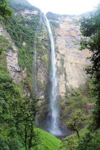
Day 3. Gocta – The 771-meter (2,530 ft) waterfall with two drops (registered as the 3rd or the 16th largest waterfall in the world, depending on who you ask). We wanted to do the hike to see the whole waterfall – both of the two drops, and we found someone who knew a guide from the village that could take us there and later pick us up for S/60.
The village that is near the waterfall (San Pablo de Valera) has organized themselves well and they require a guide from their village to accompany all visitors to the waterfall. (We paid our guide Maria S/40.) The village you pass through also charges an entrance fee (S/20), and they use the money to maintain and improve the trails to the waterfall, as well as to improve their own community. I really liked the system since it brings jobs and income to the local people while they maintain and conserve the natural area on their property, and also are able to share it with visitors.
The first stop was the pool at the base of the first drop. Unfortunately, we had another cloudy day without sun and with a little bit of rain a few times, but it was still an amazing hike with amazing views.
The second stop was a lookout point, where we could see both the upper and lower drops of the waterfall.
From there, because we had asked to see the lower drop as well, we continued the descent until we arrived at the huge pool at the very base of the fall. Again, it was cloudy, cold, and even rained a little, but that didn’t keep us from diving into the pool; afterall, how often does one get the opportunity to swim in the pool at the base of an incredible 771-meter waterfall? (Ok, I admit, it was way too cold to swim. I jumped in, screamed because it was so cold, and could only stand about 3 more minutes before I got out and hid under my rain poncho to warm up.)
From the pool, we descended about 1 hour to the nearby village where the hike ends. One of the local dogs had followed us from the very beginning, all the way to the village below, and my friends convinced our driver to let us drop the dog off closer to home.
Since we all have that adventurous spirit, we agreed that the all day hike was our favorite day of the whole trip…being surrounded by nature all day, bathing in a grand waterfall, climbing and descending, crossing through the mountains from one village to another, immersed in incredible landscapes…it was a perfect day for us all, one of the best in a lifetime.
Day 4: Karajía. For our last day, we decided on a half-day trip to Karajía (S/30 for a private car), which is where there are sarcophaguses (sarcophagi?) high up in a cliff .
It was a beautiful drive (as all the drives had been), that brought us to a little town, and from there, a short 30-minute hike to see the sarcophagi. You can’t get very close to them because they are high in the cliffs, but you can see them from below or from the sides.
Arrow points to the sarcophaguses
We dawdled a while, hiking around and taking photos and goofing off and enjoying the views, until we climbed back up the hill to the village.
Unfortunately, we only had four days to explore the area, but one could easily spend a week or more discovering Chachapoyas and the surrounding areas.
The amazing views, the history, the culture, the adventure….this trip had it all, with the best part being the memories shared, deepening our friendship, and finally traveling together – something we’d been talking about doing together for a year!